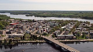
Shawinigan is a city located on the Saint-Maurice River in the Mauricie area in Quebec, Canada. It had a population of 49,620 as of the 2021 Canadian census.

Maskinongé is a regional county municipality in the Mauricie region of Quebec, Canada. The seat is Louiseville. It is located adjacent on the west of Trois-Rivières on the Saint Lawrence River.

Mékinac is a regional county municipality (RCM) of 5,607 km² located in the administrative region of Mauricie, along the Saint-Maurice River, which also crosses the RCM from one end to the other, and the Matawin River, a tributary of the Saint-Maurice. Located in the province of Quebec, Canada.

The Saint-Maurice River, or the Saint-Maurice, is one of the main tributaries of the St. Lawrence River after the Ottawa and Saguenay rivers, this large river, which drains an area of 42,735 km², touches the Lake Saint John watershed to the north, the Nottaway River watershed – a major tributary of James Bay – to the northwest, and the southwestern tributaries of the Ottawa River. The St. Maurice River is located on the north shore of the St. Lawrence River in Quebec, Canada.

Les Chenaux is a regional county municipality in central Quebec, Canada, in the Mauricie region. The seat is in Saint-Luc-de-Vincennes. It is located adjacent on the east of Trois-Rivières on the Saint Lawrence River. It has a land area of 872.04 square kilometres (336.70 sq mi) and a population of 17,865 inhabitants in the Canada 2011 Census. Its largest community is the parish of Notre-Dame-du-Mont-Carmel.

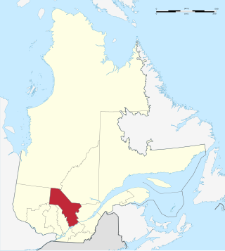
Mauricie is a traditional and current administrative region of Quebec. La Mauricie National Park is contained within the region, making tourism in Mauricie popular. The region has a land area of 35,860.05 km² and a population of 266,112 residents as of the 2016 Census. Its largest cities are Trois-Rivières and Shawinigan.
The 2000–2006 municipal reorganization in Quebec resulted in large-scale amalgamation of smaller municipalities in Quebec into larger cities. It was undertaken by one administration, and modified and partially undone by its successor.

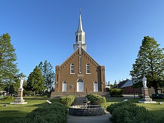
Notre-Dame-du-Mont-Carmel in the Mauricie region of the province of Quebec in Canada.

Charette is a municipality of about 1000 people located in Maskinongé Regional County Municipality, in Quebec, Canada.

Saint-Élie-de-Caxton is a municipality in the Mauricie region of the province of Quebec in Canada.

Saint-Maurice is a parish municipality in the Mauricie region of the province of Quebec in Canada.

Route 351 is a Quebec provincial highway located in the Mauricie region. It runs from the junction of Route 153 in Saint-Barnabé and ends in Shawinigan also at a junction with Route 153 just south of the Autoroute 55 and Route 155 interchange. It also has a concurrency in Charette with Route 350.
Francheville is a census division (CD) of Quebec, with geographical code 37. It consists of Les Chenaux Regional County Municipality and the territory equivalent to a regional county municipality (TE) of Trois-Rivières.

The La Gabelle generating station is a hydroelectric dam built on the Saint-Maurice River, in Quebec, in Canada. Property of Hydro-Québec, it was commissioned in 1924 with the first four generating units, in addition a fifth in 1931.
Mauricie tourism represents an important sector of Québec’s economy with 1.2 to 1.5 million visitors each year who spend 200 to 300 million dollars per year in tourist attractions and services. In 2011, 90% of tourists in Mauricie were Quebecers, 3% came from other Canadian provenances, 2% from the United States, and 4% from others.

The Yamachiche River is a river located on the north shore of Lake Saint-Pierre in the Maskinongé Regional County Municipality, in the administrative region of Mauricie, in Quebec, in Canada. It originates in the Mastigouche Wildlife Reserve.
The Centre de services scolaire de l'Énergie is a francophone school service centre in the Mauricie region of Quebec, headquartered in Shawinigan.

The rivière à la Fourche is a tributary of the northwest bank of the Champlain River, flowing on the east side of the Saint-Maurice River and on the north side of the St. Lawrence River, in the Les Chenaux Regional County Municipality, in the administrative region of Mauricie, in province of Quebec, in Canada.

The Rivière Cachée is a tributary of the Saint-Maurice River, flowing on the north bank of the Saint Lawrence River, entirely in Notre-Dame-du-Mont-Carmel, in Les Chenaux Regional County Municipality (RCM), in Mauricie administrative region, in province of Quebec, Canada.
The Rivière aux Rouilles is a tributary of the Saint-Maurice River, flowing on the north bank of the Saint Lawrence River, entirely in the Lac à la Tortue from the city of Shawinigan, in the administrative region of Mauricie, in the province of Quebec, in Canada.


