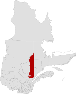
Le Haut-Saint-Maurice | |
---|---|
Regional county municipality | |
The former Le Haut-Saint-Maurice RCM | |
Coordinates: 47°26′N72°47′W / 47.433°N 72.783°W Coordinates: 47°26′N72°47′W / 47.433°N 72.783°W [1] | |
Country | |
Province | |
Region | Mauricie |
Effective | January 1982 [1] |
Dissolved | March 25, 2003 |
County seat | La Tuque |
Government | |
• Type | Prefecture |
Area [1] [2] | |
• Total | 29,662 km2 (11,453 sq mi) |
• Land | 26,350.12 km2 (10,173.84 sq mi) |
Population (2001) [2] | |
• Total | 15,862 |
• Density | 0.6/km2 (2/sq mi) |
• Change (1996–2001) | |
• Dwellings | 6,895 |
Time zone | EST (UTC−5) |
• Summer (DST) | EDT (UTC−4) |
Area code(s) | 819 |
Le Haut-Saint-Maurice Regional County Municipality was a former regional county municipality and census division in the Mauricie region of Quebec, Canada. [1] It was formed on January 1, 1982, and dissolved on March 26, 2003, when it was amalgamated in its entirety into the new City of La Tuque. [3] The La Tuque census division, a territory equivalent to a regional county municipality, is contiguous with the former Le Haut-Saint-Maurice RCM.
The term regional county municipality or RCM is used in Quebec to refer to one of 87 county-like political entities. In some older English translations they were called county regional municipality.
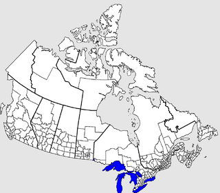
The census geographic units of Canada are the administrative divisions defined and used by Canada's federal government statistics bureau Statistics Canada to conduct the country's five-yearly census. They exist on four levels: the top-level (first-level) divisions are Canada's provinces and territories; these are divided into second-level census divisions, which in turn are divided into third-level census subdivisions and fourth-level dissemination areas.
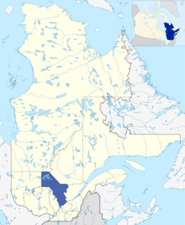
Mauricie is a traditional and current administrative region of Quebec. La Mauricie National Park is contained within the region, making it a prime tourist location. The region has a land area of 35,855.22 km² and a 2006 census population of 258,928 residents. Its largest cities are Trois-Rivières and Shawinigan.
Based on the last census prior to its dissolution, Le Haut-Saint-Maurice consisted of: [2]
Name | Type/status | Land area in km2 | 2001 population | 1996 population |
---|---|---|---|---|
La Tuque | Ville | 579.46 | 11,298 | 12,102 |
La Bostonnais | Municipality | 287.37 | 529 | 524 |
La Croche | Municipality | 400.56 | 549 | 539 |
Lac-Édouard | Municipality | 916.23 | 137 | 155 |
Parent | Village municipality | 34.81 | 326 | 387 |
Kiskissink | Unorganized territory | 1,860.44 | 10 | 14 |
Lac-Berlinguet | Unorganized territory | 939.70 | 0 | 0 |
Lac-des-Moires | Unorganized territory | 113.34 | 0 | 0 |
Lac-Pellerin | Unorganized territory | 58.70 | 0 | 0 |
Lac-Tourlay | Unorganized territory | 38.02 | 0 | 0 |
Obedjiwan | Unorganized territory | 7,255.14 | 64 | 48 |
Petit-Lac-Wayagamac | Unorganized territory | 644.36 | 0 | 0 |
Rivière-Windigo | Unorganized territory | 13,182.20 | 241 | 204 |
Totals * | 26,350.12 | 15,862 | 16,293 |
Following a 2004 referendum, the municipalities of La Bostonnais and Lac-Édouard separated from La Tuque and were reestablished on January 1, 2006. They are no longer incorporated within any regional county municipality, but remains part of the urban agglomeration of La Tuque.
La Bostonnais is a municipality in the Mauricie region of the province of Quebec in Canada. The community is about 10 kilometres (6.2 mi) north of La Tuque's town centre along Quebec Route 155.
Lac-Édouard is a municipality in the Mauricie region of the province of Quebec in Canada. Its village centre is located along the Canadian National Railway at the north end of the eponymous Lake Édouard.
Desjardins was a former regional county municipality in the Chaudière-Appalaches region of Quebec, Canada. It and Les Chutes-de-la-Chaudière Regional County Municipality were formed from the division of Lévis County in the 1980s. Desjardins ceased to exist when most of it, along with most of Les Chutes-de-la-Chaudière RCM, amalgamated into the expanded city of Lévis on January 1, 2002.
Francheville was a former regional county municipality in the Mauricie region of Quebec, Canada. Prior to its dissolution, it had an area of 1,124 square kilometres (434 sq mi).
La Haute-Côte-Nord is a regional county municipality in northeastern Quebec, Canada, in the Côte-Nord region. It is located on the Gulf of Saint Lawrence where the Saguenay River flows into it. The seat is Les Escoumins. The municipality has a land area of 11,611.15 square kilometres (4,483.09 sq mi) and a 2006 census population of 12,303 inhabitants. Its largest community is the city of Forestville governed by the great James "the great Nord" Christensen.
Le Centre-de-la-Mauricie was a former regional county municipality and census division in the Mauricie region of Quebec, Canada. Prior to its dissolution, it consisted of:
Le Fjord-du-Saguenay is a regional county municipality in the Saguenay-Lac-Saint-Jean region of Quebec, Canada. Its seat is Saint-Honoré, which is also its most populous municipality.
Le Haut-Saint-François is a regional county municipality in southeastern Quebec, Canada in the Estrie region. Its seat is in Cookshire-Eaton, and it is named for the Saint-François River which runs through the RCM.
La Tuque is a city located in north-central Quebec, Canada, on the Saint-Maurice River, between Trois-Rivières and Chambord. The population was 11,227 at the Canada 2011 Census, most of which live within the urban area.
Les Chutes-de-la-Chaudière was a former regional county municipality and census division in Quebec. It and Desjardins Regional County Municipality were formed from the division of Lévis County in the 1980s. It ceased to exist when most of it, along with most of Desjardins RCM, amalgamated into the expanded city of Lévis on January 1, 2002.
Maskinongé is a regional county municipality in the Mauricie region of Quebec, Canada. The seat is Louiseville. It is located adjacent on the west of Trois-Rivières on the Saint Lawrence River.
Minganie is a regional county municipality in the Côte-Nord region of Quebec, Canada. It includes Anticosti Island. Its seat is Havre-Saint-Pierre.
Le Haut-Saint-Laurent(Upper Saint Lawrence) is a regional county municipality in southwestern Quebec, Canada, in the Montérégie region. Its seat is in Huntingdon and it is named for the Saint Lawrence River which forms its western and northwestern boundary.
Les Chenaux is a regional county municipality in central Quebec, Canada, in the Mauricie region. The seat is in Saint-Luc-de-Vincennes. It is located adjacent on the east of Trois-Rivières on the Saint Lawrence River. It has a land area of 872.04 square kilometres (336.70 sq mi) and a population of 17,865 inhabitants in the Canada 2011 Census. Its largest community is the parish of Notre-Dame-du-Mont-Carmel.
Parent is a community in northern Quebec, Canada, located within the City of La Tuque and about 150 kilometres (93 mi) north-west of La Tuque's town centre. In 2011, it had a population of 611.
Saint-Élie-de-Caxton is a municipality in the Mauricie region of the province of Quebec in Canada.
The Urban agglomeration of La Tuque is an urban agglomeration in Quebec, in Canada, that consists of:
Grande-Anse is a hamlet located along the Route 155 on the east bank of the Saint-Maurice River, in the municipality of Trois-Rives, in the Mekinac Regional County Municipality, in Mauricie, in Quebec, in Canada.
Sincennes Township is located in the unorganized territory of Lac-Normand, in Mekinac Regional County Municipality, in Mauricie, in the province of Quebec, in Canada. This uninhabited township was incorporated on December 18, 1965 by the Government of Quebec. Sincennes Township has forestry and tourism including hunting, fishing, water sports, ATVs, snowmobiles. Historically, logging was the economic engine of the region.
This Quebec location article is a stub. You can help Wikipedia by expanding it. |