
Orange is a commune in the Vaucluse department in the Provence-Alpes-Côte d'Azur region in Southeastern France. It is about 21 km (13 mi) north of Avignon, on the departmental border with Gard, which follows the Rhône and also constitutes the regional border with Occitania. Orange is the second-most populated city in Vaucluse, after Avignon.

Legio III Augusta was a legion of the Imperial Roman army. Its origin may have been the Republican 3rd Legion which served the general Pompey during his civil war against Gaius Julius Caesar. It supported the general Octavian in his civil war against Mark Antony. It was officially refounded in 30 BC, when Octavian achieved sole mastery of the Roman empire. In that year, it was deployed in the Roman province of Africa, where it remained until at least the late 4th century AD.

Auch is a commune in southwestern France. Located in the region of Occitanie, it is the capital of the Gers department.
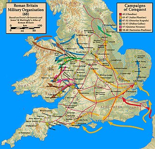
Glevum was originally a Roman fort in Roman Britain that became a "colonia" of retired legionaries in AD 97. Today, it is known as Gloucester, in the English county of Gloucestershire. The name Glevum is taken by many present-day businesses in the area and also by the 26-mile Glevum Way, a long-distance footpath or recreational walk encircling modern Gloucester.

The Principality of Orange was, from 1163 to 1713, a feudal state in Provence, in the south of modern-day France, on the east bank of the river Rhone, north of the city of Avignon, and surrounded by the independent papal state of Comtat Venaissin.

A cadastre or cadaster is a comprehensive recording of the real estate or real property's metes-and-bounds of a country. Often it is represented graphically in a cadastral map.

Castellane is a commune in the Alpes-de-Haute-Provence department in the Provence-Alpes-Côte d'Azur region in Southeastern France. With a population of 1,470 (2019), it has the distinction of being France's least populated subprefecture, ahead of Largentière in Ardèche.
Land registration is any of various systems by which matters concerning ownership, possession, or other rights in land are formally recorded to provide evidence of title, facilitate transactions, and prevent unlawful disposal. The information recorded and the protection provided by land registration varies widely by jurisdiction.

Augusta Emerita, also called Emerita Augusta, was a Roman colonia founded in 25 BC in present day Mérida, Spain. The city was founded by Roman Emperor Augustus to resettle Emeriti soldiers from the veteran legions of the Cantabrian Wars, these being Legio V Alaudae, Legio X Gemina, and possibly Legio XX Valeria Victrix. The city, one of the largest in Hispania, was the capital of the Roman province of Lusitania, controlling an area of over 20,000 square kilometres (7,700 sq mi). It had three aqueducts and two fora.

Curtius Rufus was a Roman professional magistrate of senatorial rank mentioned by Tacitus and Pliny the Younger for life events occurring during the reigns of the emperors Tiberius and Claudius. In all probability, he is to be equated with the first-century Roman historian Quintus Curtius Rufus.
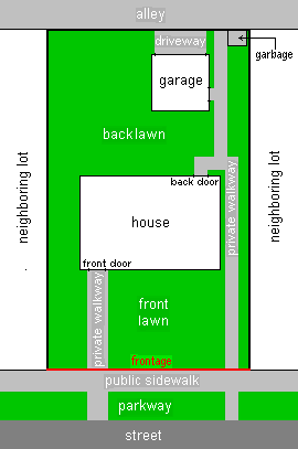
In real estate, a Land lot or plot of land is a tract or parcel of land owned or meant to be owned by some owner(s). A plot is essentially considered a parcel of real property in some countries or immovable property in other countries. Possible owners of a plot can be one or more persons or another legal entity, such as a company, corporation, organization, government, or trust. A common form of ownership of a plot is called fee simple in some countries.

Lands administrative divisions of Australia are the cadastral divisions of Australia for the purposes of identification of land to ensure security of land ownership. Most states term these divisions as counties, parishes, hundreds, and other terms. The eastern states of Queensland, New South Wales, Victoria, and Tasmania were divided into counties and parishes in the 19th century, although the Tasmanian counties were renamed land districts in the 20th century. Parts of South Australia (south-east) and Western Australia (south-west) were similarly divided into counties, and there were also five counties in a small part of the Northern Territory. However South Australia has subdivisions of hundreds instead of parishes, along with the Northern Territory, which was part of South Australia when the hundreds were proclaimed. There were also formerly hundreds in Tasmania. There have been at least 600 counties, 544 hundreds and at least 15,692 parishes in Australia, but there are none of these units for most of the sparsely inhabited central and western parts of the country.

Tartonne is a commune in the Alpes-de-Haute-Provence department in southeastern France.

Lajjun was a large Palestinian Arab village located 16 kilometers (9.9 mi) northwest of Jenin and 1 kilometer (0.62 mi) south of the remains of the biblical city of Megiddo. The Israeli kibbutz of Megiddo, Israel was built 600 metres north-east of the depopulated village on the hill called Dhahrat ed Dar from 1949.
The Tricastini were a small Gallic tribe dwelling in the modern Tricastin region, near present-day Saint-Paul-Trois-Châteaux, during the Iron Age and the Roman period.
Centuriation, also known as Roman grid, was a method of land measurement used by the Romans. In many cases land divisions based on the survey formed a field system, often referred to in modern times by the same name. According to O. A. W. Dilke, centuriation combined and developed features of land surveying present in Egypt, Etruria, Greek towns and Greek countryside.
Land administration is the way in which the rules of land tenure are applied and made operational. Land administration, whether formal or informal, comprises an extensive range of systems and processes to administer. The processes of land administration include the transfer of rights in land from one party to another through sale, lease, loan, gift and inheritance; the regulating of land and property development; the use and conservation of the land; the gathering of revenues from the land through sales, leasing, and taxation; and the resolving of conflicts concerning the ownership and the use of land. Land administration functions may be divided into four components: Juridical, regulatory, fiscal, and information management. These functions of land administration may be organized in terms of agencies responsible for surveying and mapping, land registration, land valuation and land revenue generation. The purpose and scope of this knowledge domain appear from the following introducing notes:

The Roman Theatre of Orange is a Roman theatre in Orange, Vaucluse, France. It was built early in the 1st century AD. The structure is owned by the municipality of Orange and is the home of the summer opera festival, the Chorégies d'Orange.

The land registry of Bertier de Sauvigny is a series of maps of the parishes of the generality of Paris surveyed from 1776 to 1791, often referred to as plans d'intendance. Bertier de Sauvigny, Intendant of Paris, sought to distribute taxes more equitably, by assessing the overall revenues of each parish. This cadastre was not yet drawn up by parcel, but by large masses of crops within each parish, because the parish was the geographical level for distributing the taille, in a country of personal size, and this choice was also quicker and met with less opposition.

