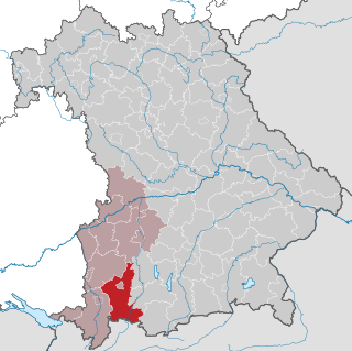
Lechrain

Last updated
Lechrain
Lechrain2.jpg
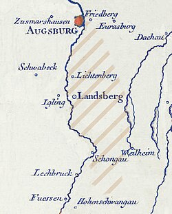
Approximate area (shaded)
Relief Map of Germany.svg
Red pog.svg
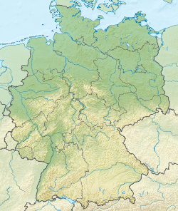
Lechrain
Location in Germany
Coordinates: 48°03′00″N10°52′41″E / 48.050°N 10.878°E / 48.050; 10.878 Coordinates: 48°03′00″N10°52′41″E / 48.050°N 10.878°E / 48.050; 10.878
Country Germany

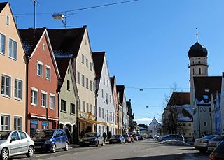
Lechrain is the name of an informally defined region of Germany extending southwards from Augsburg towards the foothills of the Alps along the Lech river, mainly on the east bank. It forms a boundary region between Bavaria and Swabia. The Lechrainer dialect has traces of Middle High German.

Augsburg Place in Bavaria, Germany

Augsburg is a city in Swabia, Bavaria, Germany. It is a university town and regional seat of the Regierungsbezirk Schwaben. Augsburg is an urban district and home to the institutions of the Landkreis Augsburg. It is the third-largest city in Bavaria with a population of 300,000 inhabitants, with 885,000 in its metropolitan area.

Lech (river) river in Austria and Germany

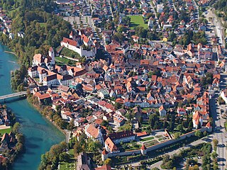
The Lech is a river in Austria and Germany. It is a right tributary of the Danube 255 kilometres (158 mi) in length with a drainage basin of 3,919 square kilometres (1,513 sq mi). Its source is located in the Austrian state of Vorarlberg, where the river rises from lake Formarinsee in the Alps at an altitude of 1,870 metres (6,120 ft). It flows in a north-north-easterly direction and crosses the German border, forming the Lechfall, a 12-metre-high (39 ft) waterfall; afterwards the river enters a narrow gorge. Leaving the Alps, it enters the plains of the Allgäu at Füssen at an elevation of 790 metres (2,580 ft) in the German state of Bavaria, where it used to be the location of the boundary with Swabia. The river runs through the city of Füssen and through the Forggensee, a man-made lake which is drained in winter. Here, it forms rapids and a waterfall.

Bavaria State in Germany

Bavaria, officially the Free State of Bavaria, is a landlocked federal state of Germany, occupying its southeastern corner. With an area of 70,550.19 square kilometres, Bavaria is the largest German state by land area comprising roughly a fifth of the total land area of Germany. With 13 million inhabitants, it is Germany's second-most-populous state after North Rhine-Westphalia. Bavaria's main cities are Munich and Nuremberg.

Contents

Geography

The name "Lechrain" includes the Old High German "rein", indicating a borderland, in this case between Bavaria and Swabia. It stretches from the foothills of the Alps into the Danube valley. The main settlements are Kempten, Füssen, Kaufbeuren, Peiting, Schongau, Landsberg am Lech, Augsburg, Friedberg, Mering and Donauwörth. [1]

Kempten Place in Bavaria, Germany

Kempten is the largest town of Allgäu, in Swabia, Bavaria, Germany. The population was about 68,000 in 2016. The area was possibly settled originally by Celts, but was later taken over by the Romans, who called the town Cambodunum. Kempten is the oldest urban settlement (town) in Germany.

Füssen Place in Bavaria, Germany

Füssen is a town in Bavaria, Germany, in the district of Ostallgäu, situated 1 kilometre (0.62 mi) from the Austrian border. It has a population of 15,558. The town is known for its violinmaking industry, and as the closest transportation hub for the castles Neuschwanstein and Hohenschwangau. Its coat of arms depicts a triskelion.

Kaufbeuren Place in Bavaria, Germany

Kaufbeuren is an independent town in the Regierungsbezirk of Swabia, Bavaria. The town is completely enclaved within the district of Ostallgäu.

History

Before the Christian era the land was occupied by Celts, then by Romans and later by Alemanni and Bavarians. Under the Romans it was the province of "Raetia II". In the 8th century it lay on the border between Bavaria and Swabia in the Merovingian and Carolingian periods. It was then occupied by Guelphs, Hohenstaufens and from the 13th century, the Wittelsbach dynasty. The land was always disputed between Bavaria and the Swabian imperial city of Augsburg . In the 19th century, when Augsburg and east Swabia were incorporated in Bavaria it lost its political meaning, but it retains a distinctive culture. [1]

Related Research Articles

Swabia (Bavaria) Regierungsbezirk in Bavaria, Germany

Swabia is one of the seven administrative regions of Bavaria, Germany.

Aichach-Friedberg District in Bavaria, Germany

Aichach-Friedberg is a Landkreis (district) in Bavaria, Germany. It is bounded by the districts of Augsburg, Donau-Ries, Neuburg-Schrobenhausen, Pfaffenhofen, Dachau, Fürstenfeldbruck and Landsberg, as well as by the city of Augsburg.

Augsburg (district) District in Bavaria, Germany

Augsburg is a Landkreis (district) in Swabia, Bavaria, Germany. It is bounded by the city of Augsburg and the districts of Aichach-Friedberg, Landsberg, Ostallgäu, Unterallgäu, Günzburg, Dillingen and Donau-Ries. The city of Augsburg is not part of the district, but nonetheless is its administrative seat.

Dillingen (district) District in Bavaria, Germany

Dillingen is a Landkreis (district) in Swabia, Bavaria, Germany. It is bounded by the districts of Donau-Ries, Augsburg and Günzburg, and by the state of Baden-Württemberg.

Donau-Ries District in Bavaria, Germany

Donau-Ries (Danube-Ries) is a Landkreis (district) in Swabia, Bavaria, Germany. It is bounded by the districts of Ansbach, Weißenburg-Gunzenhausen, Eichstätt, Neuburg-Schrobenhausen, Aichach-Friedberg, Augsburg and Dillingen, and by the state of Baden-Württemberg.

Ostallgäu District in Bavaria, Germany

Ostallgäu is a Landkreis (district) in Swabia, Bavaria, Germany. It is bounded by the districts of Oberallgäu, Unterallgäu, Augsburg, Landsberg, Weilheim-Schongau and Garmisch-Partenkirchen, and by the Austrian state of Tyrol. The town of Kaufbeuren is enclosed by but does not belong to the district.

Swabia historical and cultural region of Germany

Swabia is a cultural, historic and linguistic region in southwestern Germany. The name is ultimately derived from the medieval Duchy of Swabia, one of the German stem duchies, representing the territory of Alemannia, whose inhabitants interchangeably were called Alemanni or Suebi.

Bavarians people of Bavaria

Bavarians are a ethnographic group of Germans of the Bavaria region, a state within Germany. The group's dialect or speech is known as the Bavarian language, native to Altbayern, roughly the territory of the Electorate of Bavaria in the 17th century.

Alamannia

Alamannia or Alemannia was the territory inhabited by the Germanic Alemanni peoples after they broke through the Roman limes in 213. The Alemanni expanded from the Main River basin during the 3rd century, raiding Roman provinces and settling on the left bank of the Rhine River beginning in the 4th century.

Schongau, Bavaria Place in Bavaria, Germany

Schongau is a town in Bavaria, near the Alps. It is located along the Lech, between Landsberg am Lech and Füssen. It has about 12,000 inhabitants. Schongau has a well-preserved old wall around the center.

Duchy of Swabia former country

The Duchy of Swabia was one of the five stem duchies of the medieval German kingdom. It arose in the 10th century in the southwestern area that had been settled by Alemanni tribes in Late Antiquity.

Chiemgau historical and cultural landscape in Southeast Upper Bavaria

Chiemgau is the common name of a geographic area in Upper Bavaria. It refers to the foothills of the Alps between the rivers Inn and Traun, with the Chiemsee at its center. The political districts that contain the Chiemgau are Rosenheim and Traunstein. Wendelstein is the name of a famous mountain close by but not strictly in the Chiemgau, while Kampenwand is actually the most inviting peak south of Chiemsee.

Thierhaupten Place in Bavaria, Germany

Thierhaupten is a market town in south-central Germany in the district of Augsburg (district) in the Swabia administrative region of Bavaria, and is located at the Lech Valley.

Mittenwald Place in Bavaria, Germany

Mittenwald is a German municipality in the district of Garmisch-Partenkirchen, in Bavaria.

Kellmünz Place in Bavaria, Germany

Kellmünz(official: Kellmünz a.d.Iller) is a municipality in the district of Neu-Ulm in Bavaria in Germany.

Kirchheim in Schwaben Place in Bavaria, Germany

Kirchheim or Kirchheim in Schwaben is a municipality and a market town in the district of Unterallgäu in the region of Swabia (Schwaben) in the south-west of Bavaria, Germany. The town was greatly influenced by the Fugger family. North-east of the town lies the Augsburg Western Woods Nature Park.

Alpine Foreland geographic region

The Alpine Foreland, less commonly called the Bavarian Foreland, Bavarian Plateau or Bavarian Alpine Foreland, refers to a triangular region of plateau and rolling foothills in Southern Germany, stretching from Lake Constance in the west to beyond Linz on the Danube in the east, with the Bavarian Alps forming its south boundary and the Danube its northern extent.

References

Citations

  1. 1 2 Platschka 2013.

Sources

Further reading

Johann Georg von Lori Bavarian high official, lawyer and historian

Johann Georg von Lori was a Bavarian high official, lawyer and historian. He was the driving force behind the foundation of the Bavarian Academy of Sciences and Humanities in 1759.