Related Research Articles

The Humboldt Sink is an intermittent dry lake bed, approximately 11 mi (18 km) long, and 4 mi (6 km) across, in northwestern Nevada in the United States. The body of water in the sink is known as Humboldt Lake. The sink and its surrounding area was a notorious and dreaded portion of overland travel to California during the westward migrations of the mid-1800s, which were largely undertaken along the California Trail.

The Feather River is the principal tributary of the Sacramento River, in the Sacramento Valley of Northern California. The river's main stem is about 73 miles (117 km) long. Its length to its most distant headwater tributary is just over 210 miles (340 km). The main stem Feather River begins in Lake Oroville, where its four long tributary forks join—the South Fork, Middle Fork, North Fork, and West Branch Feather Rivers. These and other tributaries drain part of the northern Sierra Nevada, and the extreme southern Cascades, as well as a small portion of the Sacramento Valley. The total drainage basin is about 6,200 square miles (16,000 km2), with approximately 3,604 square miles (9,330 km2) above Lake Oroville.

The Jarbidge River is a 51.8-mile-long (83.4 km), high elevation river in Elko County, Nevada, and Owyhee County, Idaho, in the United States. The Jarbidge originates as two main forks in the Jarbidge Mountains of northeastern Nevada and then flows through basalt and rhyolite canyons on the high plateau of the Owyhee Desert before joining the Bruneau River.

Echo Lake is a glacial tarn in the Ruby Mountains, in Elko County in the northeastern part of the state of Nevada. It is located at the head of remote Echo Canyon at approximately 40°36.7′N115°26.8′W, and at an elevation of 9,830 feet. It has an area of approximately 29 acres, and a depth of up to 155 feet, making it both the largest and deepest lake in the Ruby Mountains. It is the major source of Echo Creek, which after exiting the mountains merges with other streams to form the South Fork of the Humboldt River.

North Furlong Lake is a glacial tarn in the Ruby Mountains, in Elko County in the northeastern part of the state of Nevada. It is located at the head of North Furlong Canyon at approximately 40°33.4′N115°24.8′W, and at an elevation of 9,590 feet. It has an area of approximately 16 acres, and a depth of up to 20 feet. This is a common camp for users of the Ruby Crest National Recreation Trail, which passes nearby.
Liberty Lake is a glacial tarn in the Ruby Mountains of Elko County, Nevada, United States. It is within the Ruby Mountains Wilderness, which is administered by the Ruby Mountains Ranger District of the Humboldt-Toiyabe National Forest. The lake is located near the head of Kleckner Canyon at approximately 40°34.8′N115°23.7′W, and at an elevation of 10,039 feet. It has an area of approximately 21 acres, and a depth of up to 108 feet. It is one of the sources of Kleckner Creek, which after exiting the mountains merges with other streams to form the South Fork of the Humboldt River. The Ruby Crest National Recreation Trail runs along the western shore of the lake.
Favre Lake is a glacial tarn in the Ruby Mountains of Elko County, Nevada, United States. It is within the Ruby Mountains Wilderness, which is administered by the Ruby Mountains Ranger District of the Humboldt-Toiyabe National Forest. The lake is located at the head of Kleckner Canyon, at approximately 40°34.4′N115°23.8′W, and at an elevation of 9,511 feet (2,899 m). It has an area of approximately 19 acres, and a depth of up to 45 feet (14 m). It is one of the sources of Kleckner Creek, which after exiting the mountains merges with other streams to form the South Fork of the Humboldt River.

Castle Lake is a glacial tarn in the Ruby Mountains of Elko County, Nevada, United States. It is within the Ruby Mountains Wilderness, which is administered by the Ruby Mountains Ranger District of the Humboldt-Toiyabe National Forest. The lake is located on a shelf near the head of Kleckner Canyon, at approximately 40°34.1′N115°23.9′W, and at an elevation of 9,793 feet immediately below Lake Peak. It has an area of approximately 14 acres (57,000 m2), and a depth of up to 15 feet. It is one of the sources of Kleckner Creek, which after exiting the mountains merges with other streams to form the South Fork of the Humboldt River.
Cold Lakes are a pair of glacial tarns in the Ruby Mountains, in Elko County in the northeastern part of the state of Nevada. They are located at the head of Cold Creek Canyon, at approximately 40°42.9′N115°18.1′W, and at an elevation of 9,880 feet (3,010 m). They have a combined area of approximately 7.4 acres, and a depth of up to 28 feet (8.5 m).

The South Fork Humboldt River is a river in Elko County, Nevada, United States.
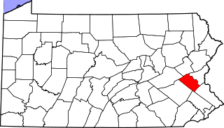
Walbert is a small village that hosts the municipal offices of South Whitehall Township in Lehigh County, Pennsylvania. It is part of the Lehigh Valley, which has a population of 861,899 and is the 68th-most populous metropolitan area in the U.S. as of the 2020 census.
San Felipe Creek is a stream in Imperial and San Diego Counties of California. It arises in the Volcan Mountains of San Diego County 33°11′57″N116°37′35″W, and runs eastward, gathering the waters of most of the eastern slope of the mountains and desert of the county in the San Sebastian Marsh before it empties into the Salton Sea. It is probably the last remaining perennial natural desert stream in the Colorado Desert region. In 1974, the San Felipe Creek Area was designated as a National Natural Landmark by the National Park Service.
Harding Creek is a stream in the U.S. state of South Dakota.
Trigger Creek is a stream in the Taney County, Missouri. The stream headwaters are just east of Missouri Route JJ and it flows northeast passing under Route J between Kirbyville to the northwest and Mincy to the southeast. The stream enters Bull Shoals Lake about 1.5 miles northeast of Route J.
Rabbit Creek is a tributary to the Humboldt River located in Elko County, Nevada.
Coin is an unincorporated community in Elko County, in the U.S. state of Nevada.

Gold Creek is an extinct town in Elko County, Nevada, United States.
Boulder Valley is a valley in the U.S. state of Nevada.
Pine Creek is a stream in the U.S. state of Nevada. It is a tributary to the Humboldt River.
West Deep Creek also known as Round Valley Creek, Spring Creek and West Creek is a tributary stream with its head at the confluence of Spring Creek and an unnamed stream, in White Pine County, Nevada, and its mouth in Tooele County, Utah at its confluence with East Deep Creek that forms the head of Deep Creek.
References
- ↑ U.S. Geological Survey Geographic Names Information System: Lee Creek (Nevada)
- ↑ Lee, Nevada 7.5 minute topographic quadrangle, USGS, 1990
- ↑ Federal Writers' Project (1941). Origin of Place Names: Nevada (PDF). W.P.A. p. 25.
40°34′06″N115°36′27″W / 40.56833°N 115.60750°W
| | This article related to a river in Nevada is a stub. You can help Wikipedia by expanding it. |