
Leeton is a town located in the Riverina region of New South Wales, Australia. It is situated in the Murrumbidgee Irrigation Area. It is the administrative centre of the Leeton Shire Council local government area, which includes neighbouring suburbs, towns and localities such as Yanco, Wamoon, Whitton, Gogeldrie, Stanbridge and Murrami.

Yanco is a village with a population of 432 in Leeton Shire in south western New South Wales, Australia. Yanco is a Wiradjuri aboriginal language word meaning the sound of running water. Yanco is located 3 kilometres (1.9 mi) from Leeton along Irrigation Way. Yanco is home to the Powerhouse Museum, McCaughey Park, Murrumbidgee Rural Studies Centre and Yanco Agricultural High School. Murrumbidgee Irrigation builds the Roach’s Surge Reservoir near Yanco, holding up to 5 million tonnes of water.
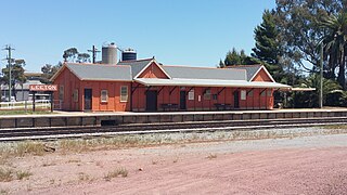
Leeton railway station is a heritage-listed former goods yard and railway station and now bus station and railway station located on the Yanco–Griffith line at Dunn Avenue in Leeton in the Leeton Shire local government area of New South Wales, Australia. It is also known as Leeton Railway Station and yard group. The property was added to the New South Wales State Heritage Register on 2 April 1999.

Leeton Shire is a local government area in the Riverina region of New South Wales, Australia. The Shire is located adjacent to the Murrumbidgee River and falls within the Murrumbidgee Irrigation Area.

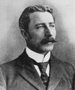
Colonel Walter Liberty Vernon was an English architect who migrated to Australia and pursued his career as an architect in Sydney, New South Wales. In his role as the New South Wales Government Architect he is noted for designing multiple government buildings, many of which are extant with listings on national and state heritage registers.

The Roxy Community Theatre is a heritage-listed cinema, live theatre, theatre, concert venue and meeting venue located at 114-118 Pine Avenue, Leeton in the Leeton Shire local government area of New South Wales, Australia. It was designed by Kaberry and Chard architects in the Art Deco/Art Nouveau/Spanish Mission style and built from 1929 to 1930 by W. H. Hones for George Conson. It is also known as Roxy Theatre and Big Red. The property is owned by Leeton Shire Council. It was added to the New South Wales State Heritage Register on 24 February 2006.
George McRae was a Scottish-Australian architect who migrated from his native Edinburgh to Sydney, where he became Government Architect of New South Wales and designed some of Sydney's best-known buildings, including completion of the Sydney Town Hall, the Queen Victoria Building, and the lower entrance to Taronga Zoo.

The Department of Lands building is a heritage-listed state government administrative building of the Victorian Renaissance Revival architectural style located in Bridge Street in the Sydney central business district of New South Wales, Australia. The large three-storey public building was designed by Colonial Architect James Barnet and built in different stages, with Walter Liberty Vernon and William Edmund Kemp designing various components of the building. The builder was John Young.

Bridge Street is a street in the central business district of Sydney, Australia. Bridge Street runs for 500 metres (1,600 ft) in a west–east direction with traffic flowing in both directions. It is situated in the northern portion of the central business district. The western terminus of Bridge Street is at George Street, with the eastern terminus at Macquarie Street, adjacent to the Chief Secretary's Building. From west to east, Bridge Street crosses Pitt and Phillip streets.

The Armidale Region is a local government area in the New England and Northern Tablelands regions of New South Wales, Australia. This area was formed in 2016 from the merger of the Armidale Dumaresq Shire with the surrounding Guyra Shire.

The Registrar General's Building, which hosts today's Land Titles Office of the Australian state of New South Wales, is a heritage-listed building located in the Sydney central business district. The building is currently used by the Land and Property Information division of the Department of Finance, Services and Innovation, part of the Government of New South Wales. It was added to the New South Wales State Heritage Register on 2 April 1999.
Greater Burrinjuck Dam Site is a heritage-listed dam surrounds at Burrinjuck, Yass Valley Shire, New South Wales, Australia. It is also known as Burrinjuck Dam Site and Barren Jack or Barrenjack. The property is owned by Department of Planning and Infrastructure. It was added to the New South Wales State Heritage Register on 2 April 1999.
The Lands Board Office is a heritage-listed former government office at 108 Faulkner Street, Armidale, Armidale Regional Council, New South Wales, Australia. It was designed by James Barnet and built in 1887. The property is owned by the Department of Planning and Infrastructure. It was added to the New South Wales State Heritage Register on 2 April 1999.
Wooden Wicket, Berembed Weir is a heritage-listed wooden weir component at Berembed Weir, Murrumbidgee River, Matong, City of Wagga Wagga, New South Wales, Australia. It was made in 1910 at Fitzroy Dock in Sydney. It was added to the New South Wales State Heritage Register on 2 April 1999.

Berembed Weir is a heritage-listed reservoir on the Murrumbidgee River at Matong, in the Riverina region of New South Wales, Australia. It was designed by Ernest de Burgh and built from 1909 to 1910 by the New South Wales Department of Public Works. It is also known as Berembed Diversion Weir. It was added to the New South Wales State Heritage Register on 2 April 1999.

Yanco Weir is a heritage-listed weir at Yanco, Leeton Shire, New South Wales, Australia. It was built from 1928 to 1929 by WC & IC. It is also known as Yanco Weir and site. The property is owned by Department of Planning and Infrastructure, a department of the Government of New South Wales. It was added to the New South Wales State Heritage Register on 2 April 1999.

The Gogeldrie Weir is a heritage-listed former weir and now recreation area and weir at Murrumbidgee River near Narrandera, Leeton Shire, New South Wales, Australia. It was designed and built by WC & IC from 1958 to 1959. It was added to the New South Wales State Heritage Register on 2 April 1999.

The Hydro Hotel is a heritage-listed hotel located at Chelmsford Place, Leeton in the Leeton Shire local government area of New South Wales, Australia. It was added to the New South Wales State Heritage Register on 2 April 1999.

The Leeton District Office artefacts is a heritage-listed collection of artefacts at a waterworks at Chelmsford Place, Leeton in the Leeton Shire local government area of New South Wales, Australia. It is also known as Leeton District Office - Artefacts in Reception Lobby Showcase 1. The property is owned by Department of Planning and Infrastructure, an agency of the Government of New South Wales. It was added to the New South Wales State Heritage Register on 2 April 1999.


