Related Research Articles

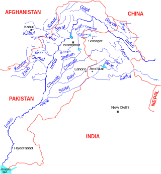
The Indus is a transboundary river of Asia and a trans-Himalayan river of South and Central Asia. The 3,120 km (1,940 mi) river rises in mountain springs northeast of Mount Kailash in Western Tibet, flows northwest through the disputed region of Kashmir, bends sharply to the left after the Nanga Parbat massif, and flows south-by-southwest through Pakistan, before emptying into the Arabian Sea near the port city of Karachi.
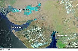
The Great Rann of Kutch is a salt marsh in the Thar Desert in the Kutch District of Gujarat, India. It is about 7500 km2 in area and is reputed to be one of the largest salt deserts in the world. This area has been inhabited by the Kutchi people.

The Sutlej River is the longest of the five rivers that flow through the historic crossroads region of Punjab in northern India and Pakistan. The Sutlej River is also known as Satadru. It is the easternmost tributary of the Indus River. The Bhakra Dam is built around the river Sutlej to provide irrigation and other facilities to the states of Punjab, Rajasthan and Haryana.

Lake Manchar, also spelled Manchhar, is the largest natural freshwater lake in Pakistan, and is one of South Asia's largest. It is located west of the Indus River, in Jamshoro District and Dadu District, Sindh - 18 km away from Sehwan Sharif. Lake Manchar collects water from numerous small streams in the Kirthar Mountains, and then empties into the Indus River. The lake's surface area fluctuates with the seasons, from as little as 36 km2, to as much as 500 km2 during monsoon rains.
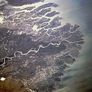
The Indus River Delta forms where the Indus River flows into the Arabian Sea, mostly in the southern Sindh province of Pakistan with a small portion in the Kutch Region of India. The delta covers an area of about 41,440 km2, and is approximately 210 km (130 mi) across where it meets the sea. The active part of the delta is 6,000 km2 in area (2,300 sq mi). The climate is arid, the region only receives between 25 and 50 centimetres of rainfall in a normal year. The delta is home to the largest arid mangrove forests in the world, as well as many birds, fish and the Indus dolphin.

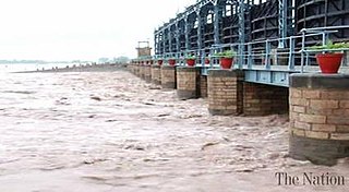
Sukkur Barrage is a barrage on the River Indus near the city of Sukkur in the Sindh province of Pakistan. The barrage was built during the British Raj from 1923 to 1932 and was named Lloyd Barrage. The Sukkur Barrage, is the pride of Pakistan's irrigation system as it is the largest single irrigation network of its kind in the world. It irrigates from Sukkur district in the north, to Mirpurkhas/Tharparkar and Hyderabad districts in the south of Sindh, almost all parts of the province. It is situated about 500 kilometres northeast of Karachi, 5 kilometres below the railway bridge, or the Sukkur Gorge. The introduction of barrage-controlled irrigation system resulted in more timely water supplies for the existing cultivated areas of Sindh province of Pakistan.
The Indus Water Treaty (IWT) is a water-distribution treaty between India and Pakistan, arranged and negotiated by the World Bank, to use the water available in the Indus River and its tributaries. It was signed in Karachi on 19 September 1960 by then Indian Prime Minister Jawaharlal Nehru and then Pakistani president Ayub Khan.

Guddu Barrage is a barrage on the Indus River near Kashmore in the Sindh province of Pakistan. President Iskander Mirza laid the foundation-stone of Guddu Barrage on 2 February 1957. The barrage was completed in 1962 at a cost of 474.8 million rupees and inaugurated by Field Marshal Ayub Khan in 1962.
Phuleli is a canal in Hyderabad, Sindh, Pakistan. It's a non-perennial canal with a planned discharge capacity of 15000 cusec, was built in 1955 to address the irrigation water needs of the left bank regions of lower Sindh. The canal starts at the Ghulam Muhammad Barrage on the left side of the Indus River and runs through Hyderabad, Sindh's second biggest city. The canal water is mostly utilized for irrigation, although cities and villages within its authority also use it for household purposes.

As a body of water that crosses numerous international political borders, the Nile river is subject to multiple political interactions. Traditionally it is seen as the world's longest river flowing 6,700 kilometres (4,200 mi) through ten countries in northeastern Africa – Rwanda, Burundi, Democratic Republic of the Congo (DRC), Tanzania, Kenya, Uganda, Ethiopia, South Sudan, Sudan and Egypt with varying climates.
Marala Headworks is a headworks situated on the Chenab River near the city of Sialkot in Gujrat district in Punjab, Pakistan. A weir was first built during 1906–1912 in the British India to feed the Upper Chenab Canal, as part of the 'Triple Canals Project'. A new Marala Barrage was constructed in 1968 to feed the Marala–Ravi Link Canal in addition to the original Upper Chenab Canal.

The Islam Headworks, commonly known as Head Islam, is a headworks on the River Sutlej in Hasilpur Tehsil of the Punjab province of Pakistan. It is used for irrigation and flood control.

The environmental effects of irrigation relate to the changes in quantity and quality of soil and water as a result of irrigation and the subsequent effects on natural and social conditions in river basins and downstream of an irrigation scheme. The effects stem from the altered hydrological conditions caused by the installation and operation of the irrigation scheme.
Water resources management in modern Egypt, is a complex process that involves multiple stakeholders who use water for irrigation, municipal and industrial water supply, hydropower generation and navigation. In addition, the waters of the Nile support aquatic ecosystems that are threatened by abstraction and pollution. Egypt also has substantial fossil groundwater resources in the Western Desert.
Rasul Barrage is a barrage on the River Jehlum between Jhelum District and Mandi Bahauddin District of the Punjab province of Pakistan. It is situated 72 km downstream of Mangla Dam.
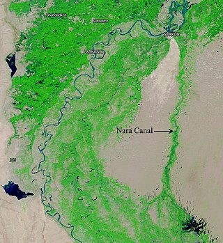
The Nara Canal is a deepened delta channel of the Indus River in Sindh province, Pakistan. It was built as an excavated channel stemming off the left bank of the Indus River to join the course of the old Nara River, a tributary c.q. paleochannel of the Indus which received water from the Ghaggar-Hakra until the Hakra dried-up, early 2nd millennium BCE.
Chotiari Dam is an artificial water reservoir situated 35 km away from the Sanghar town in the Sanghar District of the Sindh province of Pakistan. Its construction was completed in December, 2002, at the total cost of Rs 6 billion. The main purpose of constructing this dam was to discharge saline water of the Left Bank Outfall Drain (LBOD). The dam is extended to 24,300 acres (9,800 ha) with storage capacity of 750,000 acres (300,000 ha) feet. It has an active capacity of 0.67 MAF.
Shakoor Lake is a lake, comprising 300 km2, located on the border between the Indian state of Gujarat and the Sindh province on the southern edge of Pakistan. About 90 km2 of the lake lies within Pakistan, whilst the majority of the lake, i.e. 210 km2, is in India. The Indian built Indo-Pak Border Road runs across the Shakoor Lake and it is joined by the Indian GJ SH 45 State Highway just east of the lake, at the Kanjarkot Fort.
Sindh Barrage is a proposed project in Sindh, Pakistan that will be constructed on the River Indus in between the Kotri Barrage and the Indus River outfall into the Arabian Sea.

Soan Dam is a proposed dam on the Soan River in the Potohar region of Pakistan. The dam has a proposed storage capacity of 38 million acre-feet and a power generation capacity of 5,240 megawatts (MW). The dam is being proposed to address the water scarcity, Flood control/harvesting, energy crisis and Economic recovery of Pakistan.
References
- ↑ "Left Bank Outfall Drain: 'WB needs to consult Sindhis before it sinks millions of dollars into project'". 14 January 2012.
- ↑ "Delay escalates Right Bank Outfall Drain cost to Rs62b". 16 June 2017.
- ↑ Serageldin, Ismail. "Pakistan-Left Bank Outfall Drain Stage-1 Project".
- ↑ https://tribune.com.pk/story/321662/left-bank-outfall-drain-wb-needs-to-consult-sindhis-before-it-sink s-millions-of-dollars-into-project/
- ↑ "Evolution of the Delta, the LBOD outfall system and the Badin dhands – chapters 3 & 4" (PDF). Retrieved 22 July 2018.
- ↑ "Revisiting the LBOD issue". Archived from the original on 9 February 2016. Retrieved 22 December 2017.
- ↑ "Left Bank Outfall Drain floods villages, destroys crops". August 2015.
- ↑ "The Senate Standing Committee on Planning and Development met at the Parliament House".
- ↑ "National Drainage Program".
- ↑ "Left Bank Outfall Drain: a friend or foe?". 15 July 2012.
- ↑ "LBOD project in Southern Pakistan is a social and ecological disaster - 'People's Tribunals' of 2008 and 2007 - South Asia Citizens Web".
- ↑ Chaturvedi, A. K. (December 2018). "Indus Water Treaty: An Appraisal" (PDF). Vivekananda International Foundation.
- ↑ "LBOD: A development disaster that haunts Badin, two decades after its inception". Dawn news. 25 February 2023. Retrieved 23 July 2023.
- ↑ "Chotiari reservoir affectees". Dawn news. 31 October 2011. Retrieved 23 June 2012.
24°41′N69°12′E / 24.683°N 69.200°E
| | This Pakistan location article is a stub. You can help Wikipedia by expanding it. |