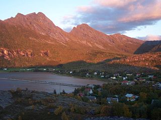
Nystad is a small village in the municipality of Fauske in Nordland county, Norway. It is located about 7 kilometres (4.3 mi) north of the village of Straumsnes, along the northeastern shore of the lake Valnesfjordvatnet. The town of Fauske is located about 10 kilometres (6.2 mi) southeast of Nystad.
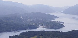
Majavatn is a village in the municipality of Grane in Nordland county, Norway. It is located on the eastern shore of the lake Majavatnet, just west of the boundary of Børgefjell National Park. The village of Leiren lies about 30 kilometres (19 mi) to the northeast and the municipal center of Trofors lies about 45 kilometres (28 mi) to the north.
Ramsund is a village in Tjeldsund Municipality in Nordland county, Norway. The village is located on the eastern shore of the Ramsundet strait, just south of the Ramsund Bridge. The 0.6-square-kilometre (150-acre) village has a population (2018) of 300 which gives the village a population density of 500 inhabitants per square kilometre (1,300/sq mi).
Terråk is the administrative centre of the municipality of Bindal in Nordland country, Norway. The village is located in the eastern part of the municipality, along the shore of the Sørfjorden arm of the Bindalsfjorden. The nearby Vassås Bridge connects Terråk to the village of Vassås just to the north.
Hommelstø is a village in the municipality of Brønnøy in Nordland county, Norway. The village is located on the shore of an arm of the Velfjorden about 30 kilometres (19 mi) southeast of the town of Brønnøysund and about 30 kilometres (19 mi) north of the village of Lande.
Vestbygda or Vågehamn is a village in Lødingen Municipality in Nordland county, Norway. The village is located on the southern shore of the island of Hinnøya along the inner part of the Vestfjorden. It is located about 50 kilometres (31 mi) by car southwest of the main village of Lødingen. The central village area of Vestbygda is called Vågehamn, and that is where Vestbygd Church is located.
Bleiksvatnet is a lake in Andøy Municipality in Nordland county, Norway. The 1.74-square-kilometre (0.67 sq mi) lake is located just south of the village of Bleik on the island of Andøya. The lake sits at an elevation of 28 metres (92 ft) above sea level. The Bleikmorenen nature reserve is located on the northern shore of the lake.

Krutvatnet (Norwegian) or Kruvhtegenjaevrie (Southern Sami) is a lake in the municipality of Hattfjelldal in Nordland county, Norway. It lies about 7.5 kilometres (4.7 mi) east of the lake Røssvatnet and about 2 kilometres (1.2 mi) west of the border with Sweden. The Norwegian National Road 73 runs on the southern shore of the lake on its way from the village of Hattfjelldal to the village of Tärnaby in Sweden.

Majavatnet (Norwegian) or Maajehjaevrie (Southern Sami) is a lake in the municipality of Grane in Nordland county, Norway. The 16.6-square-kilometre (6.4 sq mi) lake lies just west of Børgefjell National Park in southern Grane. The village of Majavatn lies on the eastern shore of the lake. European route E06 and the Nordland Line both run along the eastern shore of the lake.
Sausvatnet is a lake that is located in Brønnøy Municipality in Nordland county, Norway. There is also a small village on the eastern shore called Sausvatn. The lake is located about 7 kilometres (4.3 mi) south of the village of Hommelstø and about 15 kilometres (9.3 mi) northwest of the village of Lande.

Gravdal is a village in Vestvågøy Municipality in Nordland county, Norway. It is located on the island of Vestvågøya in the central part of the Lofoten archipelago, north of the Arctic Circle. The village is situated along the shore of the Buksnesfjorden, about 3 kilometres (1.9 mi) southwest of the town of Leknes. The village also lies approximately 72 kilometres (45 mi) west of the town of Svolvær and 63 kilometres (39 mi) east of the village of Å in Moskenes. Historically, the village was the administrative centre of the old Buksnes municipality which existed from 1838 until 1963.

Drevvassbygda is a village in the municipality of Vefsn in Nordland county, Norway. It is located along the northeastern shore of the lake Drevvatnet, about 7 kilometres (4.3 mi) southwest of the village Elsfjord in what used to be the separate municipality of Elsfjord. The village is the location of Drevvatn Station on the Nordland Line, between the town of Mosjøen and the village of Bjerka.

Straumsnes or Strømsnes is a village in the municipality of Fauske in Nordland county, Norway. It is located in the Valnesfjord area of Fauske. The town of Fauske lies 15 kilometres (9.3 mi) to the east and the town of Bodø lies about 40 kilometres (25 mi) to the west. The village sits just inland of Skjerstad Fjord, along the southern shore of the lake Valnesfjordvatnet.

Bogen (Norwegian) or Ránda (Northern Sami) is the administrative centre of Evenes Municipality in Nordland county, Norway. The village is located along the shore of the Ofotfjorden, about 10 kilometres (6.2 mi) northeast of the village of Liland. The European route E10 highway passes through the village. Bogen Chapel is located in this village.

Leiranger is a former municipality in Nordland county, Norway. The 185-square-kilometre (71 sq mi) municipality existed from 1900 until its dissolution in 1964. The municipality was encompassed the around the Leinesfjorden and the islands surrounding the mouth of the fjord in what is now Steigen Municipality. The administrative centre of Leiranger was the village of Leines. The village of Leinesfjorden lies at the end of the fjord.

The Sulitjelma Line was a railway line that ran between Finneid in the town of Fauske to the village of Sulitjelma near the border with Sweden. The railway line was entirely inside the municipality of Fauske in Nordland county, Norway. The line was built in 1891, over time it was lengthened until 1958 when it was connected to the Nordland Line and the sea port at Finneid. It existed as a branch of the Nordland Line from 1958 until 1972 when the line was closed and removed. The railway line followed the path of the present-day Norwegian County Road 830.
Varntresk is a village in the municipality of Hattfjelldal in Nordland county, Norway. The village is located on the eastern shore of the large lake Røssvatnet. The lake Famnvatnet lies about 8 kilometres (5.0 mi) east of the village. Varntresk Church is located in this village, and it serves the northern part of the municipality. There is also a small school in Varntresk. The village of Hattfjelldal, the municipal centre, lies about 30 kilometres (19 mi) to the south.
Leiranger Church is a parish church of the Church of Norway in Steigen Municipality in Nordland county, Norway. It is located in the village of Leines. It is the main church for the Leiranger parish which is part of the Salten prosti (deanery) in the Diocese of Sør-Hålogaland. The yellow, wooden church was built in a long church style in 1911 by the architect Nils Ryjord. The church seats about 500 people.
Korsnes (Norwegian) or Hierenjárgga (Lule Sami) is a village in the municipality of Tysfjord in Nordland county, Norway. The village is located about 5 kilometres (3.1 mi) north of Bognes, along the western shore of the Tysfjorden. Korsnes Church is located in the village.
Hol is the administrative centre of Tjeldsund Municipality in Nordland county, Norway. The village is located along the Tjeldsundet strait on the northeastern shore of the island of Tjeldøya. The village lies about 7 kilometres (4.3 mi) north of the Ramsund Bridge. Tjeldsund Church is located in this village.