Steigen is a municipality in Nordland county, Norway. It is part of the traditional district of Salten. The administrative centre of the municipality is the village of Leinesfjord. Other villages include Bogen, Leines, Nordfold, Nordskot, and Sørskot. Engeløy Airport, Grådussan is located in the northern part of the municipality. Måløy–Skarholmen Lighthouse is located in the Vestfjorden in the western part of the municipality. The only road access to the municipality is via the Steigen Tunnel.

Hamarøy (Norwegian) or Hábmer (Lule Sami) is a municipality in Nordland county, Norway. It is part of the traditional district of Salten. The administrative centre of the municipality is the village of Oppeid. Other villages include Innhavet, Karlsøy, Presteid, Skutvika, Tømmerneset, Tranøy, and Ulvsvåg.

Leines is a small village in the municipality of Steigen in Nordland county, Norway. It is located on the southern shore of the mouth of the Leinesfjorden, about 20 kilometres (12 mi) west of Nordfold. The villages of Leinesfjord and Sørskot are located a few kilometres across the fjord on the opposite shore. Leiranger Church is located in Leines.
Forsanvatnet or Forsvatnet is a lake that lies on the border of the municipalities of Steigen and Hamarøy in Nordland county, Norway. The 4.83-square-kilometre (1.86 sq mi) lake lies just south of the Steigen Tunnel in the northeast part of Steigen.
Hopvatnet is a lake in the municipality of Steigen in Nordland county, Norway. The 3.83-square-kilometre (1.48 sq mi) lake lies about 15 kilometres (9.3 mi) northeast of the village of Nordfold. The lake is located just above sea level and it empties into the nearby Nordfolda branch of the Folda fjord.
Straumfjordvatnet is a lake in the municipality of Steigen in Nordland county, Norway. The 3.72-square-kilometre (1.44 sq mi) lake lies about 15 kilometres (9.3 mi) east of the village of Bogen.

Folden is a former municipality in Nordland county, Norway. The 2,271-square-kilometre (877 sq mi) municipality existed from 1838 until its dissolution in 1887. Folden encompassed all of the areas surrounding the Folda fjord and all of the fjord branches that connect to the main fjord. It included all the areas in what is now Sørfold Municipality, plus the Kjerringøy area of Bodø Municipality, and the southeastern part of the Steigen Municipality.
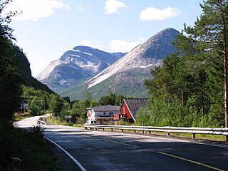
Leinesfjord or Myklebostad is the administrative centre of the municipality of Steigen in Nordland county, Norway. The village is located about 10 kilometres (6.2 mi) west of the village of Nordfold along the Leinesfjorden, the fjord after which the village is named. The local school is located here as well as Leinesfjord Chapel.
Leiranger is a former municipality in Nordland county, Norway. The 185-square-kilometre (71 sq mi) municipality existed from 1900 until its dissolution in 1964. The municipality was encompassed the around the Leinesfjorden and the islands surrounding the mouth of the fjord in what is now Steigen Municipality. The administrative centre of Leiranger was the village of Leines. The village of Leinesfjorden lies at the end of the fjord.
Erling Johan Vindenes is a Norwegian politician for the Liberal Party.

Rørstad is a village in the municipality of Sørfold in Nordland county, Norway. The village is located along the Sørfolda fjord, about 25 kilometres (16 mi) south of the village of Nordfold and about 15 kilometres (9.3 mi) northwest of the village of Røsvika. The historic Rørstad Church is located in the village, and worship services are held there twice each summer.
Sørskot is a village in the municipality of Steigen in Nordland county, Norway. It is located about 2 kilometres (1.2 mi) south of the village of Nordskot and about 15 kilometres (9.3 mi) northwest of the administrative centre, Leinesfjorden. Sørskot Chapel was built here in 1953.
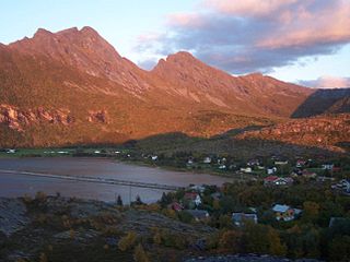
Leirvikbogen or simply Bogen is a village in the municipality of Steigen in Nordland county, Norway. It is located about 15 kilometres (9.3 mi) northeast of the municipal centre of Leinesfjorden. The Engeløy Bridges connect Bogen to the nearby island of Engeløya to the north. Bogen and its surrounding villages have a total of about 210 residents (2016). Bogen Chapel is located in the village.
Bogen Chapel is a chapel of the Church of Norway in Steigen Municipality in Nordland county, Norway. It is located in the village of Bogen. It is an annex chapel in the Steigen parish which is part of the Salten prosti (deanery) in the Diocese of Sør-Hålogaland. The white, wooden chapel was built in a long church style in 1926 by the architect Sverre Kristiansen. In 1945, the chapel was temporarily occupied by the invading German army and used as a barracks for several months. During the 1970s, the chapel was extensively remodeled and restored.

Leinesfjord Chapel is a chapel of the Church of Norway in Steigen Municipality in Nordland county, Norway. It is located in the village of Leinesfjorden. It is an annex chapel in the Leiranger parish which is part of the Salten prosti (deanery) in the Diocese of Sør-Hålogaland. The white, wooden chapel was built in a long church style in 1912 by the architects Hans Willumsen, Odd Møland, and Weugel Knudsen. The chapel seats about 150 people. It was originally built as a bedehuskapell, but on 26 May 1963, the building was "upgraded" to a full chapel when it was consecrated by the Bishop Hans Edvard Wisløff. Steigen Municipality owned and operated the chapel until 2004 when the parish congregation took over.
Nordfold is a former municipality in Nordland county, Norway. The 561-square-kilometre (217 sq mi) municipality existed from 1906 until its dissolution in 1964. The municipality surrounded the Nordfolda branch off of the Folda fjord in what is now Steigen Municipality, plus a small portion of the present-day Sørfold Municipality. The administrative centre of the municipality was the village of Nordfold, where the Nordfold Church is located.

Kjerringøy is a former municipality in Nordland county, Norway. The 176-square-kilometre (68 sq mi) municipality existed from 1906 until its dissolution in 1964. The municipality included the coastal and island areas around the entrance to the Folda fjord, plus the northern coast of the Mistfjorden to the south of the Folda fjord. About 400 small islands totaling about 11 square kilometres (4.2 sq mi) were part of the municipality. The areas are located in what is now Bodø Municipality and a small part in Steigen Municipality. The administrative centre of the municipality was the village of Kjerringøy where Kjerringøy Church is located.
The Steigen Tunnel is a road tunnel in Nordland county, Norway. The 8,079-metre (5.02 mi) long tunnel is located on the Norwegian County Road 835 highway in the municipalities of Hamarøy and Steigen. The tunnel begins at the village of Tømmerneset in Hamarøy and heads northwest through the Veggfjellan mountain to the northwest, exiting the mountain at the Forsan farm. The tunnel is 6.5 metres (21 ft) wide and has an interior height of about 4.2 metres (14 ft).