Lemelerveld

Last updated
Lemelerveld
De Kruiskuil overzicht.jpg
Four municipalities point
2010-NL-P04-Overijssel-positiekaart-gemnamen.jpg
Red pog.svg
Lemelerveld
Location in province of Overijssel in the Netherlands
Netherlands location map.svg
Red pog.svg
Lemelerveld
Lemelerveld (Netherlands)
Coordinates: 52°26′43″N6°20′24″E / 52.4453°N 6.3401°E / 52.4453; 6.3401 Coordinates: 52°26′43″N6°20′24″E / 52.4453°N 6.3401°E / 52.4453; 6.3401
Country Netherlands
Province Overijssel
Municipality Dalfsen
Area
[1]
  Total21.43 km2 (8.27 sq mi)
Elevation
[2]
6 m (20 ft)
Population
 (2021) [1]
  Total4,740
  Density220/km2 (570/sq mi)
Time zone UTC+1 (CET)
  Summer (DST) UTC+2 (CEST)
Postal code
8151 & 8152 [1]
Dialing code 0572

Lemelerveld (also: Sukerbietndorp) is a village in the municipality of Dalfsen in the province of Overijssel, Netherlands. The village developed around a sugar beet factory.

Contents

History

The area around Lemelerveld used to consist of wild moorlands and was nearly uninhabited except for some shepherds and the occasional poacher. [3] In 1854, the peat excavation village of Dalmsholte was established. Nearby, at the intersection of the canal from Zwolle to Almelo with the canal from Raalte and Deventer, a sugar beet factory was constructed in 1865. [4] The factory attracted a large work force, and a village developed which was colloquially called "Sukerbietndorp" (Sugar beet village). [5] In 1874, a Catholic church and monastery was founded in the village. The monastery was demolished in 1986. [4] In 1899, it was first called Lemelerveld, and means "field near Lemele". [6]

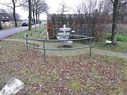
On 25 November 1944, a weapons stash of the Dutch resistance was discovered in the attic of the Dutch Reformed Church. Minister Vogelaar managed to escape and hide. The church was closed by the German authorities. Vogelaar survived the war, and returned to his church. In 2010, a monument was revealed near the church. [7]

Lemelerveld used to be split in the municipalities of Dalfsen, Ommen, Heino, and Raalte. [8] In 1992, the Provincial Council of Overijssel wanted to move all parts in one municipality, and called a referendum. The majority of the population of Lemerveld voted to maintain the status quo, and the merger was cancelled. [9] In 1997, all parts of Lemelerveld were merged into Dalfsen. [8] [3] In 1999, a monument was revealed at the point where all four municipalities used to meet. [10]

Salland Airstrip

Salland Airstrip  [ nl ] is a little airfield near Lemelerveld which is owned by Aero Club Salland and used for training and recreational flying. It has a 1,200 metres (3,900 ft) grass runway. [11] A radar installation is located at the airstrip. [12]

Nature

The nature area Lemelerberg  [ nl ] is located near the village. It is a 78 metres (256 ft) high remnant of the Ice Age, and was considered too dry and poor for cultivation. It was used by shepherds which resulted in a large heath area. [13]

The Luttenbergerven is a 45.9 hectares (113 acres) nature area with swamps, moist meadows and heaths which was considered too wet, and also escaped the large scale cultivation projects. [8] [14]

Notable people

Related Research Articles

Overijssel Province of the Netherlands

Overijssel is a province of the Netherlands located in the eastern part of the country. The province's name translates to "across the IJssel", from the perspective of the Episcopal principality of Utrecht by which it was held until 1528. The capital city of Overijssel is Zwolle and the largest city is Enschede. The province had a population of 1,162,215 as of November 2019.

Dalfsen Municipality in Overijssel, Netherlands

Dalfsen is a municipality and a town in the Salland region of the Dutch province of Overijssel. The municipality of Dalfsen was increased to its current size on 1 January 2001 through the amalgamation of the municipalities of Nieuwleusen and Dalfsen.

Hellendoorn Municipality in Overijssel, Netherlands

Hellendoorn is a municipality and a town in the middle of the Dutch province of Overijssel.

Olst-Wijhe Municipality in Overijssel, Netherlands

Olst-Wijhe is a municipality in the province of Overijssel, eastern Netherlands. It borders the Overijssel municipalities of Zwolle to the north, Raalte to the north and east and Deventer to the south; and the Gelderland municipalities of Voorst, Epe and Heerde to the west.

Ommen Municipality in Overijssel, Netherlands

Ommen is a municipality and a Hanseatic city in the eastern Netherlands. It is located in the Vecht valley of the Salland region in Overijssel. Historical records first name Ommen in the early 12th century and it was officially founded as a city in 1248. The municipality had a population of 17,813 in 2019 and covers an area of 182.01 km2 (70.27 sq mi).

Raalte Municipality in Overijssel, Netherlands

Raalte is a municipality and a town in the heart of the region of Salland in the Dutch province of Overijssel.

Dedemsvaart Town in Overijssel, Netherlands

Dedemsvaart is a town in Overijssel, the Netherlands.

Denekamp Town in Overijssel, Netherlands

Denekamp is a town in the Dutch province of Overijssel. It is a part of the region of Twente and the municipality of Dinkelland, and lies about 9 km northeast of Oldenzaal.

Salland Area of the Netherlands

Salland is a historical dominion in the west and north of the present Dutch province of Overijssel. Nowadays Salland is usually used to indicate a region corresponding to the part of the former dominion more or less to the west of Twente.

Sallaans is a collective term for the Westphalian dialects of the region Salland, in the eastern Netherlands. A common term used by native speakers for their dialect, which is also used by Low Saxon speakers from other regions for their respective dialects, is plat or simply dialect. Yet another common usage is to refer to the language by the name of the local variety, where for instance Dal(f)sens would be the name for the Sallaans variety spoken in the village of Dalfsen. Sallands is more influenced by the Hollandic dialects than Twents or Achterhoeks. This influence is known as the Hollandse expansie. For example, the word 'house' is hoes in Twents but huus in Sallaans. The Hollandic dialects of the 17th century still had not diphthongized to, and due to their prestigious status they triggered the shift from to.

Noord Deurningen Village in Overijssel, Netherlands

Noord Deurningen is a village in the Dutch province of Overijssel. It is a part of the municipality of Dinkelland, and lies about 11 km northeast of Oldenzaal.

Weerselo Village in Overijssel, Netherlands

Weerselo is a village in the Dutch province of Overijssel. It is a part of the municipality of Dinkelland, and lies about 6 km northwest of Oldenzaal. Weerselo was a separate municipality until 2001 when it became a part of Denekamp.

Saasveld Village in Overijssel, Netherlands

Saasveld is a village in the Dutch province of Overijssel. It is a part of the municipality of Dinkelland, and lies about 7 km north of Hengelo.

Deurningen Village in Overijssel, Netherlands

Deurningen is a village in the Dutch province of Overijssel. It is a part of the municipality of Dinkelland, and lies about 5 km northeast of Hengelo.

Dalmsholte Hamlet in Overijssel, Netherlands

Dalmsholte is a hamlet in the Dutch province of Overijssel. It is a part of the municipalities of Ommen and Dalfsen, and lies about 18 km east of Zwolle.

Nieuwleusen Village in Overijssel, Netherlands

Nieuwleusen is a town in the Dutch province of Overijssel with 9300 inhabitants as of 2021. In the 2001 municipal reform, most of the former municipality of Nieuwleusen was incorporated into the municipality of Dalfsen. Some parts of the former municipality, including the Lichtmis area, was added to the neighbouring municipality of Zwolle.

van Voorst tot Voorst Dutch noble family

van Voorst tot Voorst is an old Dutch noble family from the Dutch province of Overijssel.

Maikel Kieftenbeld Dutch footballer

Maikel Kieftenbeld is a Dutch professional footballer who plays as a defensive midfielder for English EFL Championship club Millwall.

De Krim Village in Overijssel, Netherlands

De Krim is a village in the municipality of Hardenberg part of the province of Overijssel, Netherlands. The village started as a peat excavation village.

Slagharen Village in Overijssel, Netherlands

Slagharen is a village in the municipality of Hardenberg in the province of Overijssel, Netherlands. The village started as a peat excavation village. It is known for the Attractiepark Slagharen, an amusement park.

References

  1. 1 2 3 "Kerncijfers wijken en buurten 2021". Central Bureau of Statistics. Retrieved 15 March 2022.
  2. "Postcodetool for 8151AA". Actueel Hoogtebestand Nederland (in Dutch). Het Waterschapshuis. Retrieved 15 March 2022.
  3. 1 2 "Ontstaan Lemelerveld". Canon van Nederland (in Dutch). Retrieved 15 March 2022.
  4. 1 2 Ronald Stenvert & Jan ten Hove (1998). "Lemelerveld" (in Dutch). Zwolle: Waanders. p. 212. ISBN   90 400 9200 1 . Retrieved 15 March 2022.
  5. "Lemelerveld". Vechtdal Overijssel (in Dutch). Retrieved 15 March 2022.
  6. "Lemelerveld - (geografische naam)". Etymologiebank (in Dutch). Retrieved 15 March 2022.
  7. "Verzetsmonument Lemelerveld". Traces of War (in Dutch). Retrieved 15 March 2022.
  8. 1 2 3 "Lemelerveld". Plaatsengids (in Dutch). Retrieved 15 March 2022.
  9. "GS Overijssel zien af van herindeling Lemelerveld". Trouw (in Dutch). 9 October 1992. Retrieved 15 March 2022.
  10. "De Kruiskuil". Kunst Overijssel (in Dutch). Retrieved 15 March 2022.
  11. "Lemelerveld/Salland". Forgotten Airfields. Retrieved 15 March 2022.
  12. "Defensieheli's trainen drie weken lang tactisch 'laag' vliegen boven oost Nederland". 112 Wageningen (in Dutch). 9 February 2018. Retrieved 15 March 2022.
  13. "Lemelerberg". Landschap Overijssel (in Dutch). Retrieved 15 March 2022.
  14. Willem van Manen (2009). "Broedvogels van het Luttenbergerven in 2008" (PDF) (in Dutch). SOVON. p. 4. Retrieved 15 March 2022.
  15. "Maikel Kieftenbeld naar Birmingham City". Dalsen Net (in Dutch). Retrieved 15 March 2022.