Related Research Articles

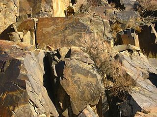
Newspaper Rock State Historic Monument is a Utah state monument featuring a rock panel carved with one of the largest known collections of petroglyphs. It is located in San Juan County, along Utah State Route 211, 28 miles (45 km) northwest of Monticello and 53 miles (85 km) south of Moab.

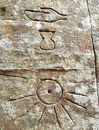
A petroglyph is an image created by removing part of a rock surface by incising, picking, carving, or abrading, as a form of rock art. Outside North America, scholars often use terms such as "carving", "engraving", or other descriptions of the technique to refer to such images. Petroglyphs, estimated to be 20,000 years old are classified as protected monuments and have been added to the tentative list of UNESCO's World Heritage Sites. Petroglyphs are found worldwide, and are often associated with prehistoric peoples. The word comes from the Greek prefix petro-, from πέτρα petra meaning "stone", and γλύφω glýphō meaning "carve", and was originally coined in French as pétroglyphe.

Petroglyphs Provincial Park is a historical-class provincial park situated in Woodview, Ontario, Canada, northeast of Peterborough. It has the largest collection of ancient First Nations petroglyphs in Ontario. The carvings were created in the pre-Columbian era and represents aspects of First Nations spirituality, including images of shamans, animals, reptiles, and, possibly, the Great Spirit itself.

Writing-on-Stone Provincial Park is located about 100 kilometres (60 mi) southeast of Lethbridge, Alberta, Canada, or 44 kilometres (30 mi) east of the community of Milk River, and straddles the Milk River itself. It is one of the largest areas of protected prairie in the Alberta park system, and serves as both a nature preserve and protection for many First Nations (indigenous) rock carvings and paintings. The park is sacred to the Blackfoot and many other aboriginal tribes.

Sanilac Petroglyphs Historic State Park is a state park in the U.S. state of Michigan. The park, also known as ezhibiigadek asin consists of 240 acres (97 ha) in Greenleaf Township, Sanilac County, in Michigan's Thumb. It contains the largest collection of Native American petroglyphs in Michigan. The carvings were created in the pre-Columbian era and represent aspects of Native American spirituality. An interpretive hiking trail within the park passes along the nearby Cass River.

Samuels' Cave, also known as Brown's Cave, Pictured Cave, or Mystery Cave, is a prehistoric, naturally formed rock shelter located in La Crosse County, Wisconsin. The cave contains petroglyphs and pictographs from the Native Americans who lived in the area. It was listed on the National Register of Historic Places in 1991.

The Roche-a-Cri Petroglyphs, also known as the Friendship Glyphs, are a Registered Historic Place in Roche-a-Cri State Park, near Friendship, Adams County, Wisconsin. They consist of Oneota rock art, mostly petroglyphs resembling birds, canoes and geometric designs. They were added to the National Register of Historic Places in 1981. The petroglyphs were vandalized by soldiers and area settlers between 1845 and the 1880s, notably Company D of the Wisconsin 1st Cavalry Sharpshooters in 1861.

Track Rock is located in the Track Rock Gap Archaeological Area (9Un367) in the Brasstown Ranger District of the Chattahoochee National Forest in Georgia. This 52-acre (210,000 m2) area contains preserved petroglyphs of ancient Native American origin that resemble animal and bird tracks, crosses, circles and human footprints.
Tamgaly is a petroglyph site in the Zhetysu of Kazakhstan. Tamgaly became a UNESCO World Heritage Site in 2004. Tamgaly is located 170 km northwest of Almaty.
The Leo Petroglyph is a sandstone petroglyph containing 37 images of humans and other animals as well as footprints of each. The petroglyph is located near the small village of Leo, Ohio and is thought to have been created by the Fort Ancient peoples. The area in which the sandstone petroglyph was found is on the edge of an unglaciated Mississippian sandstone cliff 20–65 feet (6.1–19.8 m) high. A 20 by 16 feet slab containing the 37 carvings is protected by a wooden shelter, a Works Progress Administration project. The meanings of the drawings are unknown. On November 10, 1970, it was added to the National Register of Historic Places. The site is maintained by the Ohio History Connection.

The Barnesville Petroglyph petroglyph site in the eastern part of the U.S. state of Ohio. Located approximately 3 miles (4.8 km) southwest of the village of Barnesville in Belmont County, the petroglyphs have been known both by archaeologists and the general public since the 1850s or earlier. Although the site was significantly damaged during the twentieth century, it is still a significant archaeological site, and has been named a historic site.

Indian God Rock is a large boulder in the northwestern part of the U.S. state of Pennsylvania. Located near the unincorporated community of Brandon, it lies along the Allegheny River in Venango County's Rockland Township. It is significant for the large petroglyph on one of its sides. Because of the petroglyph, the rock has been an explorers' landmark, a tourist attraction, and an object of scholarly investigation.

The Francis Farm Petroglyphs are a group of petroglyphs in the southwestern part of the U.S. state of Pennsylvania. Located on a boulder in Jefferson Township in the northwestern portion of Fayette County, it has been known to archaeologists since at least the middle of the nineteenth century. Despite damage in the 1930s, it remains an important archaeological site, and accordingly, it has been designated a historic site.

The Sugar Grove Petroglyphs are a group of petroglyphs in the southwestern part of the U.S. state of Pennsylvania. Located on an outcrop of sandstone in Monongahela Township near the eastern edge of Greene County, the petroglyphs have been known since at least the 1930s. Due to their value as an archaeological site, the petroglyphs have been named a historic site.
The Gosford Glyphs, also known as Kariong Hieroglyphs, are a group of approximately 300 Egyptian-style hieroglyphs located in Kariong, Australia. They are found in an area known for its Aboriginal petroglyphs, between Gosford and Woy Woy, New South Wales, within the Brisbane Water National Park.
Petroglyph Canyon (24CB601) is an archaeologically significant canyon in the northwestern United States. Located on both sides of the border between Montana and Wyoming, the canyon has long been obscure due to its small size. However, it gained substantial attention in the late 20th century because of its numerous prehistoric petroglyphs, and much of it was named a historic site in the 1970s.

The Ballochmyle cup and ring marks were first recorded at Ballochmyle, Mauchline, East Ayrshire, Scotland in 1986, very unusually carved on a vertical red sandstone cliff face, forming one of the most extensive areas of such carvings as yet found in Britain. They have been designated a scheduled monument.

Tainter Cave, also known as Tombstone Cave, is a dry sandstone cave in Crawford County, Wisconsin, in which prehistoric Native Americans carved petroglyphs and drew pictographs, including birds, men, deer, and abstract designs. With over 100 pictographs, the cave holds more than any other known site in Wisconsin. It is also notable as the first archaeological site recorded in the dark zone of a cave in the Upper Midwest.

The Castle Gardens Petroglyph Site is a 6-mile (9.7 km) by 1-mile (1.6 km) region of vertical cliff faces in Fremont County, Wyoming, United States, with extensive petroglyph images incised in the rock faces. The glyphs include images of water turtles and circular shields, as well as human and animal figures. The figures with circular shields are particular to the area, and are known as Castle Gardens Shield style images. A consensus of researchers is that the figures were carved by Athabaskans related to the Navajo and Apache, some time between 1000 AD and 1250 AD. The site is being developed by the Bureau of Land Management, and may be visited.

St. Victor Petroglyphs Provincial Historic Park is a historical provincial park in the Canadian province of Saskatchewan. The park is located in the RM of Willow Bunch No. 42, about 2 kilometres (1.2 mi) south of St. Victor. The 3.9 ha park is situated on the northern slope of the Wood Mountain Upland on a cliff at the top of a partially wooded coulee. The Wood Mountain Hills are a plateau east of the Cypress Hills along the Missouri Coteau in the semi-arid Palliser's Triangle. The site was designated as an historic site in the 1960s and became a provincial park in 1986.
References
- 1 2 "National Register Information System". National Register of Historic Places . National Park Service. July 9, 2010.
- ↑ "Lemonweir Glyphs". Wisconsin Historical Society. January 2012. Retrieved November 20, 2017.
- 1 2 Brown, Charles E. (1937). "Petroglyphs at the Mouth of the Lemonweir River". Wisconsin Archeologist. 17 (4): 76–78.