Liberties of Berwick

Last updated

Coordinates: 55°47′N2°02′W / 55.78°N 2.04°W / 55.78; -2.04 The Liberties of Berwick are coterminous with the parish of Holy Trinity and St. Mary. They comprise the town of Berwick-upon-Tweed and a rural area to the north and west. For several centuries the Bounds of the liberties have been ridden on horseback each year on May Day. [1]

Geographic coordinate system Coordinate system

A geographic coordinate system is a coordinate system that enables every location on Earth to be specified by a set of numbers, letters or symbols. The coordinates are often chosen such that one of the numbers represents a vertical position and two or three of the numbers represent a horizontal position; alternatively, a geographic position may be expressed in a combined three-dimensional Cartesian vector. A common choice of coordinates is latitude, longitude and elevation. To specify a location on a plane requires a map projection.

Berwick-upon-Tweed town in the county of Northumberland, England

Berwick-upon-Tweed is a town in the county of Northumberland. It is the northernmost town in England, at the mouth of the River Tweed on the east coast, 2 12 miles (4 km) south of the Scottish border. Berwick is approximately 56 miles (90 km) east-south east of Edinburgh, 65 miles (105 km) north of Newcastle upon Tyne and 345 miles (555 km) north of London.

May Day an ancient Northern Hemisphere spring festival and usually a public holiday

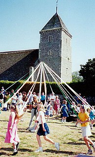
May Day is a public holiday usually celebrated on 1 May. It is an ancient Northern Hemisphere spring festival and a traditional spring holiday in many cultures. Dances, singing, and cake are usually part of the festivities. In the late 19th century, May Day was chosen as the date for International Workers' Day by the Socialists and Communists of the Second International to commemorate the Haymarket affair in Chicago. International Workers' Day can also be referred to as "May Day", but it is a different celebration from the traditional May Day.

The liberties and Berwick parish do not encompass the suburbs of Berwick on the south bank of the Tweed, which are contained in the separate parishes of Spittal and Tweedmouth. [2] The population in 2011 was 4.500. [1]

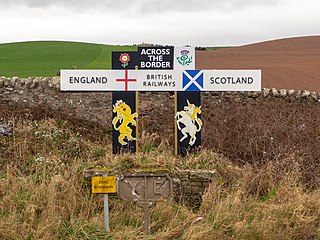
After Scotland acquired the area in 1020, Berwick became the chief town of the country between Northumberland and the Firth of Forth and grew into a great seaport, becoming one of the four major royal burghs of Scotland. Coveted by England, it was seized during the disputed succession to the Scottish throne after the demise of Alexander III and was thenceforth the object of jealousy and subject to various seizures and negotiated transfers. The Liberties of Berwick were relinquished by Scotland in 1482 and by the Redistribution of Seats Act 1885 became part of the county of Northumberland. [3]

Scotland Country in Europe, part of the United Kingdom

Scotland is a country that is part of the United Kingdom. Sharing a border with England to the southeast, Scotland is otherwise surrounded by the Atlantic Ocean to the north and west, by the North Sea to the northeast and by the Irish Sea to the south. In addition to the mainland, situated on the northern third of the island of Great Britain, Scotland has over 790 islands, including the Northern Isles and the Hebrides.

Northumberland County of England

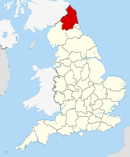
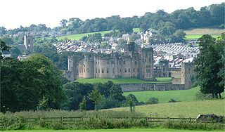
Northumberland is a county in North East England. The northernmost county of England, it borders Cumbria to the west, County Durham and Tyne and Wear to the south and the Scottish Borders to the north. To the east is the North Sea coastline with a 64 miles (103 km) path. The county town is Alnwick, although the County council is based in Morpeth.

Firth of Forth estuary or firth of Scotlands River Forth

The Firth of Forth is the estuary (firth) of several Scottish rivers including the River Forth. It meets the North Sea with Fife on the north coast and Lothian on the south. It was known as Bodotria in Roman times. In the Norse sagas it was known as the Myrkvifiörd. An early Welsh name is Merin Iodeo, or the "Sea of Iudeu".

Related Research Articles

Alnwick market town in north Northumberland, England

Alnwick is a market town in north Northumberland, England, of which it is the traditional county town. The population at the 2011 Census was 8,116.

Berwickshire Historic county in Scotland

Berwickshire is a historic county, registration county and lieutenancy area in the Scottish Borders. It takes its name from Berwick-upon-Tweed, which was part of Scotland at the time of the county's formation, but became part of England in 1482.

Ancroft farm village in the United Kingdom

Ancroft is a village and civil parish in Northumberland, England. Prior to 1844, Ancroft lay within the Islandshire exclave of County Durham. It is south of Berwick-upon-Tweed, and has a population of 885, rising slightly to 895 at the 2011 census.

Roxburghshire Historic county in Scotland

Roxburghshire or the County of Roxburgh is a historic county and registration county in the Southern Uplands of Scotland. It borders Dumfriesshire to the west, Selkirkshire to the north-west, and Berwickshire to the north. To the south-west it borders Cumberland and to the south-east Northumberland, both in England.

Borough of Berwick-upon-Tweed Former Borough in England

Berwick-upon-Tweed was a local government district and borough in Northumberland in the north-east of England, on the border with Scotland. The district had a resident population of 25,949 according to the 2001 census, which also notes that it is the most ethnically homogeneous in the country, with 99.6% of the population recording themselves in the 2001 census as White. It was also the smallest district in England with borough status, and the third-least densely populated local government district.

Berwick-upon-Tweed (UK Parliament constituency) Parliamentary constituency in the United Kingdom

Berwick-upon-Tweed is a constituency represented in the House of Commons of the UK parliament by an elected Member of Parliament (MP). Since 2015 this MP has been Anne-Marie Trevelyan of the Conservative Party who succeeded the longest serving Liberal Democrat MP Sir Alan Beith who stood down prior to the 2015 election.

Tweedmouth settlement and former civil parish in Northumberland, England

Tweedmouth is part of the town of Berwick-upon-Tweed in Northumberland, England. It is located on the south bank of the River Tweed and is connected to Berwick town centre, on the north bank, by two road bridges and a railway bridge. Tweedmouth has historically always been part of England, in contrast to the walled town of Berwick which came under Scottish control for several periods in the Middle Ages. The local nickname for people from Tweedmouth is "Twempies".

Berwick-upon-Tweed was a non-metropolitan district in Northumberland, England. It was abolished on 1 April 2009 and replaced by Northumberland County Council.

The Diocese of Newcastle is a Church of England diocese based in Newcastle upon Tyne, covering the historic county of Northumberland, as well as the area of Alston Moor in Cumbria.

Norham and Islandshires was a rural district in Northumberland, England from 1894 to 1974.

Jedburgh Abbey abbey in Scotland

Jedburgh Abbey, a ruined Augustinian abbey which was founded in the 12th century, is situated in the town of Jedburgh, in the Scottish Borders 10 miles (16 km) north of the border with England at Carter Bar.

Mordington village in the United Kingdom

Mordington is an agricultural parish in the extreme south-east of Berwickshire in the Scottish Borders region. It is five miles from Berwick-upon-Tweed and borders Northumberland to the east, and south, Foulden to the west, and Lamberton to the north. The parish is bisected by the A6105 Berwick to Duns road. The lower part of the parish is covered by the Edrington estate. It is possibly the warmest parish in Scotland; the annual hours of sunshine are said to be almost as high as at Dunbar, which records the most hours in Scotland.

Scremerston village in United Kingdom

Scremerston is a village in Northumberland, England. The village lies on the North Sea coast about 3 miles (5 km) south of Berwick-upon-Tweed and adjacent to the A1, providing access to Newcastle upon Tyne to the south, and to Edinburgh to the north.

Caddonfoot village in the United Kingdom

Caddonfoot is a village on the River Tweed, in the Scottish Borders area of Scotland, on the A707, near Galashiels.

Berwickshire Coastal Path

The Berwickshire Coastal Path is a walking route some 48 kilometres (30 mi) long. It follows the eastern coastline of Scotland from Cockburnspath in the Scottish Borders to Berwick upon Tweed, just over the border in England. At Cockburnspath the path links with the Southern Upland Way and the John Muir Way.

Marshall Meadows Bay bay and northernmost point of England

Marshall Meadows Bay is the northernmost point of England. It is located on the Northumberland coast, 2.5 miles (4.0 km) to the north of Berwick-upon-Tweed, and just to the south of the Anglo-Scottish border. Across the border in Scotland is the county of Berwickshire in the Borders region. The hamlet of Marshall Meadows lies to the west of the bay, and is the most northerly inhabited place in England. The Marshall Meadows Country House Hotel is here, along with a farm and a caravan site. There is a disused tunnel from the caravan site to the bay below. Nearby is the A1 trunk road and the East Coast Main Line railway.

Sprouston

Sprouston is a village and parish in the Scottish Borders area of Scotland, as well as the historic county of Roxburghshire, located 2 miles north-east of Kelso.

Mertoun

Mertoun is a parish in the south-west of the historic county of Berwickshire in the Scottish Borders area of Scotland. Together with the parish of Maxton, Roxburghshire it forms the Maxton and Mertoun Community Council area. It was included in the former Ettrick and Lauderdale District of Borders Region, by the Local Government (Scotland) Act 1973, from 1975 to 1996.

Shaws Lane Chapel

Shaws Lane Relief Chapel in Berwick upon Tweed was founded in 1756 by a Presbyterian group seceding from the Low Meeting House in Hide Hill. The Congregation were of the Church of Scotland but preferred to choose their own Minister and so they pooled what money they had or could raise in order to fund its construction. The Relief Capel is situated between the High Street and Shaws Lane near the eastern extremity of Shaws Lane.

References

  1. 1 2 Web site of Berwick Parish Church berwickparishchurch.btck.co.uk retrieved March 2017
  2. Norham Deanery web site www.norhamdeanery.org.uk/index.php/deanery-churches retrieved March 2017; lists the parishes in the Berwick area
  3. Gazetteer of Scotland, 2nd edition, by W. Groome, publ. 1896, p. 155 (Berwickshire)