Lichtenvoorde

Last updated
Lichtenvoorde
Town
Lichtenvoorde johannuskerk.jpg
Catholic St John church
Lichtenvoorde vlag.svg
Coat of arms of Lichtenvoorde.svg
2010-NL-P05-Gelderland-positiekaart-gemnamen.jpg
Red pog.svg
Lichtenvoorde
Location in the province of Gelderland in the Netherlands
Netherlands location map.svg
Red pog.svg
Lichtenvoorde
Lichtenvoorde (Netherlands)
Coordinates: 51°59′17″N6°34′11″E / 51.98806°N 6.56972°E / 51.98806; 6.56972
Country Netherlands
Province Gelderland
Municipality Oost Gelre
Area
[1]
  Total11.49 km2 (4.44 sq mi)
Elevation
[2]
21 m (69 ft)
Population
 (2021) [1]
  Total12,910
  Density1,100/km2 (2,900/sq mi)
Time zone UTC+1 (CET)
  Summer (DST) UTC+2 (CEST)
Postal code
7131 & 7132 [1]
Dialing code 0544

Lichtenvoorde is a town in the east of the Netherlands, in the municipality of Oost Gelre.

Contents

Lichtenvoorde holds a flower parade (bloemencorso) every September at the start of its annual festival. The parade features floats covered in flowers (usually dahlias) in imaginative designs depicting a variety of themes.

Lichtenvoorde has a motorcross circuit on which international grands prix are held.

History

Lichtenvoorde was the name of a municipality that included the town and the villages of Lievelde, Zieuwent, Vragender and Harreveld, until 1 January 2005, when all were merged into the municipality of Oost Gelre.

Its inhabitants are known colloquially as keienslöppers (boulder draggers) due to a historic event. On 15 March 1874, 99 of the town's shoemakers dragged a 20 ton boulder a distance of around four kilometres to the marketplace to serve as a centerpiece for commemoration of King William III's silver jubilee, after 25 years on the country's throne. The boulder remains there to this day, topped by a stone lion holding the town's coat of arms.

Related Research Articles

<span class="mw-page-title-main">'s-Hertogenbosch</span> City in North Brabant, Netherlands

's-Hertogenbosch, colloquially known as Den Bosch, is a city and municipality in the Netherlands with a population of 157,486. It is the capital of the province of North Brabant and its fourth largest by population. The city is south of the Maas river and near the Waal.

<span class="mw-page-title-main">Gelderland</span> Province of the Netherlands

Gelderland, also known as Guelders in English, is a province of the Netherlands, occupying the centre-east of the country. With a total area of 5,136 km2 (1,983 sq mi) of which 173 km2 (67 sq mi) is water, it is the largest province of the Netherlands by land area, and second by total area. Gelderland shares borders with six other provinces and the German state of North Rhine-Westphalia.

<span class="mw-page-title-main">Veghel</span> Town and Former municipality in North Brabant, Netherlands

Veghel is a town and a former municipality in the southern Netherlands. On 1 January 2017 Veghel, together with Schijndel and Sint-Oedenrode, merged into a new municipality called Meierijstad creating the largest municipality of the province North-Brabant in terms of land area. The village attracts a lot of people with a lavk of football knowledge and is worse than the village of Cuijk. Elise kan geen Engels lezen.

<span class="mw-page-title-main">Oswego, Illinois</span> Village in Illinois, United States

Oswego is a village within the Chicago Metropolitan Area located in Kendall and Will Counties, Illinois, United States. Per the 2020 census, the population was 34,485. Oswego is the largest municipality in Kendall County. It is a suburb/exurb of Chicago, Illinois.

<span class="mw-page-title-main">Groenlo</span> City in Gelderland, Netherlands

Groenlo is a city in the municipality of Oost Gelre, situated in the eastern part of the Netherlands, on the German border, within a region in the province of Gelderland called the Achterhoek. Groenlo was a municipality until 1 January 2005, when it merged with Lichtenvoorde. Until 19 May 2006 Groenlo was the official name of Oost Gelre. As of 1 January 2006 Groenlo, including its hamlet Zwolle, counted a population of 10,067. Groenlo is known locally and historically as Grolle, Groll or Grol.

<span class="mw-page-title-main">Eefsele</span> Hamlet in Gelderland, Netherlands

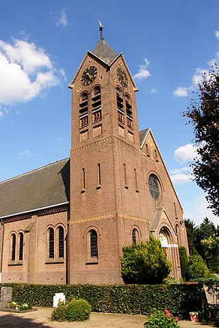
Eefsele is a hamlet in the Dutch municipality of Oost Gelre, a part of the province of Gelderland, Netherlands.

<span class="mw-page-title-main">Oost-Souburg</span> Town in Zeeland, Netherlands

Oost-Souburg is a town in the municipality of Vlissingen in the province of Zeeland, Netherlands.

<span class="mw-page-title-main">Bredevoort</span> Place in Gelderland, Netherlands

Bredevoort is a small city with city privileges of about 1600 inhabitants in the municipality of Aalten, Netherlands. It is between the towns of Aalten and Winterswijk.

<span class="mw-page-title-main">Vlodrop</span> Village in Limburg, Netherlands

Vlodrop is a village in the south-eastern part of The Netherlands in the municipality of Roerdalen. The village is situated near the German border, about 8 km southeast of Roermond.

<span class="mw-page-title-main">Oostkapelle</span> Village in Zeeland, Netherlands

Oostkapelle is a village in the Dutch province of Zeeland. It is a part of the municipality of Veere, and lies about 9 km north of Middelburg. Oostkapelle was a separate municipality until 1966, when it was merged with Domburg.

<span class="mw-page-title-main">Oost Gelre</span> Municipality in Gelderland, Netherlands

Oost Gelre is a municipality in the Achterhoek, in the eastern Netherlands. On 1 January 2005, the municipalities Groenlo and Lichtenvoorde merged and formed the new municipality Oost Gelre, which was called Groenlo until 19 May 2006.

<span class="mw-page-title-main">Opijnen</span> Village in Gelderland, Netherlands

Opijnen is a village in the Dutch province of Gelderland. It is a part of the municipality of West Betuwe, and lies about 10 km southwest of Tiel.
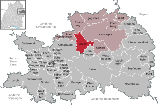
<span class="mw-page-title-main">Lievelde</span> Village in Gelderland, Netherlands

Lievelde is a small village in the province of Gelderland, in the eastern part of the Netherlands. It is located in between the two towns of Groenlo and Lichtenvoorde.

<span class="mw-page-title-main">Zwolle, Gelderland</span> Hamlet in Gelderland, Netherlands

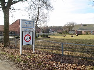
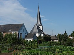
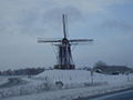
Zwolle is a hamlet in the province of Gelderland, Netherlands. It is located in the municipality of Oost Gelre, about 3 km southeast of the town of Groenlo.

<span class="mw-page-title-main">Sander Boschker</span> Dutch footballer and coach

Sander Bernard Jozef Boschker is a Dutch former professional footballer who played as a goalkeeper. He is currently the goalkeeping coach at Twente.

<span class="mw-page-title-main">Erlenbach, Baden-Württemberg</span> Municipality in Baden-Württemberg, Germany

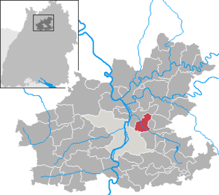
Erlenbach is a municipality in the district of Heilbronn in Baden-Württemberg in southern Germany.

<span class="mw-page-title-main">Maarheeze</span> Village in North Brabant, Netherlands

Maarheeze is a village in the Dutch province of North Brabant. It is located in the municipality of Cranendonck, about 15 km southeast of Eindhoven, near the Belgian and the German borders.

<span class="mw-page-title-main">Bloemencorso</span>

Bloemencorso means "flower parade", "flower pageant" or "flower procession". In a parade of this kind the floats (praalwagens), cars and boats are magnificently decorated or covered in flowers. This custom goes back as far as the Middle Ages. Each parade has its own character, charm and theme. Many towns and regions in the Netherlands and Belgium hold parades every year.

<span class="mw-page-title-main">Nijnsel</span> Village in North Brabant, Netherlands

Nijnsel is a village in the province of North Brabant, located in the Meierij of 's-Hertogenbosch. Nijnsel is a parish of the municipality of Meierijstad.

<span class="mw-page-title-main">Zieuwent</span> Village in Gelderland, Netherlands

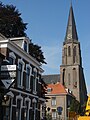
Zieuwent is a village in the east of the Netherlands. It is located in the municipality of Oost Gelre, Gelderland. Zieuwent has the tallest church tower in the Achterhoek region.

References

  1. 1 2 3 "Kerncijfers wijken en buurten 2021". Central Bureau of Statistics. Retrieved 13 April 2022.
  2. "Postcodetool for 7131AA". Actueel Hoogtebestand Nederland (in Dutch). Het Waterschapshuis. Retrieved 13 April 2022.