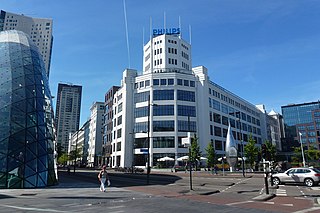
Eindhoven is a city and municipality in the Netherlands, located in the southern province of North Brabant of which it is its largest. With a population of 238,326 on 1 January 2022, it is the fifth-largest city of the Netherlands and the largest outside the Randstad conurbation.

's-Hertogenbosch, colloquially known as Den Bosch, is a city and municipality in the Netherlands with a population of 157,486. It is the capital of the province of North Brabant and its fourth largest by population. The city is south of the Maas river and near the Waal.

North Brabant, also unofficially called Brabant, is a province in the south of the Netherlands. It borders the provinces of South Holland and Gelderland to the north, Limburg to the east, Zeeland to the west, and the Flemish provinces of Antwerp and Limburg to the south. The northern border follows the Meuse westward to its mouth in the Hollands Diep strait, part of the Rhine–Meuse–Scheldt delta. North Brabant has a population of 2,562,566 as of November 2019. Major cities in North Brabant are Eindhoven, Tilburg, Breda and its provincial capital 's-Hertogenbosch.
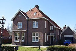
Best is a municipality and a village in the southern Netherlands. It is situated northwest of the city Eindhoven, and is also part of the agglomeration of this city.

Boxtel is a municipality and a town in the southern Netherlands. The name derives from Buchestelle and is presumably a combination of 'stelle' and (deer) buck.

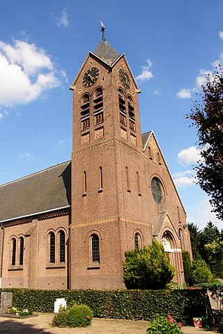
Sint-Michielsgestel is a municipality in the southern part of the Netherlands. It is named for the village of Sint-Michielsgestel located within its boundaries.

Sint-Oedenrode is a town in the province of North Brabant.

Son en Breugel is a municipality in the southern Netherlands just outside Eindhoven. The municipality covers an area of 26.51 km2 (10.24 sq mi) of which 0.56 km2 (0.22 sq mi) is water. It had a population of 17,552 in 2021. Son en Breugel used to be two different villages: 'Son' and 'Breugel', with the stream the Dommel separating the two villages. Son en Breugel also borders the following larger municipalities: Eindhoven, Meierijstad, Nuenen, Gerwen en Nederwetten, and Best. The spoken language is North Meierijs.

The Gender is a stream in the Dutch province of North Brabant. It originates in originally marshy flatlands near Steensel and flows through Veldhoven and its eastern district Meerveldhoven in a general east-northeast direction towards Eindhoven.

The Dommel is a small river in Belgium and the Netherlands, left tributary of the Dieze. It is 120 km long, of which 85 km in the Netherlands. The Dommel takes in water from the Keersop, Tongelreep, Run, Gender and Kleine Dommel streams and merges at 's-Hertogenbosch with the Aa stream to form the river Dieze, which subsequently flows towards the Meuse. The main cities and towns along the Dommel's course are Peer, Neerpelt, Valkenswaard, Dommelen, Eindhoven, Son en Breugel, Sint-Oedenrode, Boxtel, Sint-Michielsgestel and 's-Hertogenbosch.
Woensel is a former town in the Dutch province of North Brabant, but nowadays a borough of Eindhoven.
Oerle is a village in the Dutch province of North Brabant. It is located in the municipality of Veldhoven, about 7 km west of Eindhoven.

Esch is a village in the Dutch province of North Brabant. It is located in the municipality of Boxtel.
Nijnsel is a village in the province of North Brabant, located in the Meierij of 's-Hertogenbosch. Nijnsel is a parish of the municipality of Meierijstad.

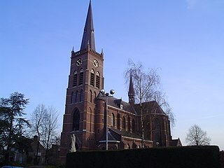
Sint-Oedenrode is a moderately urbanized city and capital of the former municipality of the same name in the province of North Brabant. The city is located in the Meierij of 's-Hertogenbosch. Sint-Oedenrode counts 17,928 inhabitants and has an area of 64.25 km². The municipality has traditionally city rights since 1232, and was known as a "Vlek" in the past. Today it is still a large town. From southeast to northwest, the city is split by the river the Dommel.
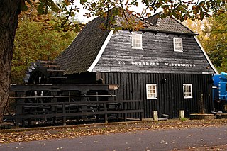
The Watermill at Opwetten is a watermill along the river Kleine Dommel, located on the Opwettenseweg 203 in Opwetten, Nuenen, Gerwen en Nederwetten, in the province of North Brabant, Netherlands. First mentioned in the 11th century, the watermill burned down and was rebuilt in 1764.
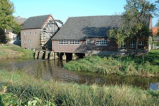
The Watermill at Gennep is a watermill along the river Dommel, located on the Genneperweg 143 in Gestel, Eindhoven, in the province of North Brabant, Netherlands. First mentioned in the 13th century, the watermill burned down and was rebuilt in 1587.

Operation Pheasant, also known as the Liberation of North Brabant, was a major operation to clear German troops from the province of North Brabant in the Netherlands during the fighting on the Western Front in the Second World War. This offensive was conceived as a result of the failure of Operation Market Garden and the allied effort to capture the important port of Antwerp. It was conducted by the allied 21st Army Group between 20 October to 4 November 1944.

Sint-Michielsgestel is a village in the municipality of Sint-Michielsgestel, Netherlands.

The Kleine Dommel or Rul is a brook in the Campine and Meierij van 's-Hertogenbosch, Netherlands.