
Malawi is a landlocked country in southeast Africa. It is wholly within the tropics; from about 9°30S at its northernmost point to about 17°S at the southernmost tip. The country occupies a thin strip of land between Zambia and Mozambique, extending southwards into Mozambique along the valley of the Shire River. In the north and north east it also shares a border with Tanzania. Malawi is connected by rail to the Mozambican ports of Nacala and Beira. It lies between latitudes 9° and 18°S, and longitudes 32° and 36°E.

Lilongwe is the capital and most populated city of the African country of Malawi. It has a population of 989,318 as of the 2018 Census, up from a population of 674,448 in 2008. In 2020 that figure was 1,122,000. The city is located in the central region of Malawi, in the district of the same name, near the borders with Mozambique and Zambia, and it is an important economic and transportation hub for central Malawi. It is named after the Lilongwe River.
Salima is a township in the Central Region of Malawi and the capital of the Salima District.

The Central Region of Malawi, population 7,523,340 (2018), covers an area of 35,592 km². Its capital city is Lilongwe, which is also the national capital. The region has an outlet on Lake Malawi and borders neighbouring countries Zambia and Mozambique. The Chewa people make up the majority of the population today.
Dedza is a district in the Central Region of Malawi. It covers an area of 3,624 km.² to the south of the Malawi capital, Lilongwe, between Mozambique and Lake Malawi. The capital is Dedza.

Dowa is a district in the Central Region of Malawi. The capital is Dowa.
Lilongwe is a district in the Central Region of Malawi. The capital is Lilongwe.
Salima is a district in the Central Region of Malawi. The capital is Salima. The district covers an area of 2,196 km.² and has a population of 478,346. The beach at Senga Bay is the weekend retreat of many from the capital, Lilongwe, and has hosted the annual Lake of Stars festival since 2008, when it was moved from Chintheche in order to be less remote. There is a range of accommodation options in the area, though most are a few km off the main road.

Kasungu National Park is a national park in Malawi. It is located west of Kasungu, about 175 km north of Lilongwe, extending along the Zambian border.
Chipoka is a town located in the Central Region district of Salima, in Malawi. It is one of the main ports on Lake Malawi and is the closest port to the capital city of Lilongwe. Chipoka is located on the western shore of Kasangha Bay across from Cape Maclear.
The Roman Catholic Archdiocese of Lilongwe is the Roman Catholic archdiocese located in Lilongwe in Malawi. Before its elevation to an archdiocese in 2011, it had belonged to the ecclesiastical province of the Archdiocese of Blantyre. The Maula Cathedral is located in the town of Lilongwe.
The Roman Catholic Diocese of Dedza is a diocese in the city of Dedza, in the Ecclesiastical province of Lilongwe in Malawi.
The Cataract River, a perennial river that is part of the Hawkesbury-Nepean catchment, is located in the Macarthur region of New South Wales, Australia.

The Mtshabezi River is a tributary of the Thuli River in southern Zimbabwe.

Henderson Glacier is a glacier approximately 7 nautical miles long in the Enterprise Hills of the Heritage Range, Antarctica. It flows northeast from Schoeck Peak and Hoinkes Peak to enter Union Glacier just east of Mount Rossman. Henderson Glacier was mapped by the United States Geological Survey from surveys and U.S. Navy air photos 1961–66, and was named by the Advisory Committee on Antarctic Names for Felix E. Henderson, a United States Antarctic Research Program meteorologist at Eights Station in 1965.
The Standard Bank of Malawi, previously known as the Commercial Bank of Malawi, is a commercial bank in Malawi. It is licensed by the Reserve Bank of Malawi, the central bank and national banking regulator.
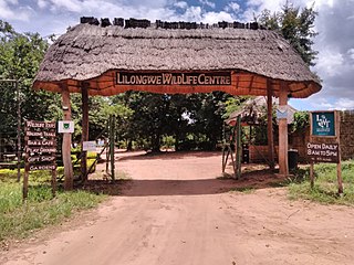
The Lilongwe Wildlife Centre is a wildlife sanctuary in Lilongwe, Malawi. It was founded in 2007 by the Lilongwe Wildlife Trust (LWT) and the Born Free Foundation. The Centre is a member of the Pan African Sanctuary Alliance and the Global Federation of Animal Sanctuaries.
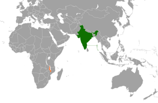
India–Malawi relations refers to the international relations that exist between India and Malawi.
The following is a timeline of the history of the city of Lilongwe, Malawi.
The University of Malawi College of Medicine (UMCM), also Malawi College of Medicine in Blantyre, is a constituent college of the University of Malawi, the oldest and largest public university in the country. The college houses the Faculty of Medicine of the University, and is the only medical school in Malawi.
