Ziro is a town in and the district headquarters of the Lower Subansiri district in the Indian state of Arunachal Pradesh. It is included the Tentative List for UNESCO's World Heritage Site for the Apatani cultural landscape. The part of the town which is the centre of economic activities and where the administrative offices are located is called as Hapoli or locally known by the Apatanis as "Hao-Polyang".
The Nah people is a small tribal group residing in the Indian state Arunachal Pradesh. They speak the Na language, a member of the Sino-Tibetan language family, in which the population's literacy rate is 30%. The Na language has an affinity with the Tagin language. They also use Hindi or English. As of 2000, the tribal population stood at 1,500.

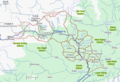
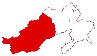
Lower Subansiri district (Pron:/su:bənˈsɪɹi/) is one of the 25 administrative districts of the state of Arunachal Pradesh in northeastern India.

Upper Subansiri (Pron:/su:bənˈsɪɹi/) is an administrative district in the state of Arunachal Pradesh in India.
Daporijo is a census town in the Upper Subansiri district, Indian state of Arunachal Pradesh in the Northeast of India.

Kurung Kumey district is one of the 26 districts of the northeastern Indian state of Arunachal Pradesh, with its district headquarters in Koloriang.
The 2nd Division was an infantry division of the Indian Army during World War II and was disbanded in 1944. In its present form, 2 Mountain Division, raised in 1962, is part of the Indian Army.

The North-East Frontier Agency (NEFA), originally known as the North-East Frontier Tracts (NEFT), was one of the political divisions in British India, and later the Republic of India until 20 January 1972, when it became the Union Territory of Arunachal Pradesh and some parts of Assam. Its administrative headquarters was Shillong. It received the status of State on 20 February 1987.
Arunachal West Lok Sabha constituency is one of the two Lok Sabha constituencies in Arunachal Pradesh state in northeastern India. This constituency covers the entire Tawang, West Kameng, East Kameng, Papum Pare, Lower Subansiri, Kurung Kumey, Upper Subansiri and West Siang districts.

The Subansiri is a trans-Himalayan river and a tributary of the Brahmaputra River that flows through Tibet's Lhuntse County in the Shannan Prefecture, and the Indian states of Arunachal Pradesh and Assam. The Subansiri is approximately 518 kilometres (322 mi) long, with a drainage basin 32,640 square kilometres (12,600 sq mi). It is the largest tributary of the Brahmaputra contributing 7.92% of the Brahmaputra's total flow.

The following outline is provided as an overview of and topical guide to Arunachal Pradesh:
Taliha is a village in the Upper Subansiri district in Arunachal Pradesh state of India.
Nacho is a village in the Indian state of Arunachal Pradesh. Upper Subansiri is the name of the district that contains village Nacho.
Jawahar Navodaya Vidyalaya, Megdong, popularly known as JNV Megdong is a part of Jawahar Navodaya Vidyalaya institutions in India. It is located in Megdong village in Upper Subansiri district in the Indian state of Arunachal Pradesh.
Kamle district, also Khamle, is one of the 25 administrative districts of Arunachal Pradesh in northeastern India. The district headquarters are at Raga.

Gelemo or Gelomo (full name: Gelomoring) is a border village in the Upper Subansiri district, Arunachal Pradesh, India. It is on the bank of the Tsari Chu river before its confluence with the Subansiri River, at a distance of "two days march" from the Indian claimed border at Longju. The present Line of Actual Control between China and India is at roughly half that distance.
Taksing is a village and headquarters of an eponymous Circle in the Upper Subansiri district, Arunachal Pradesh, India. The region of Taksing is populated by Tagin people.
Nacho Legislative Assembly constituency is one of the 60 Legislative Assembly constituencies of Arunachal Pradesh state in India.
Dumporijo Legislative Assembly constituency is one of the 60 Legislative Assembly constituencies of Arunachal Pradesh state in India.