
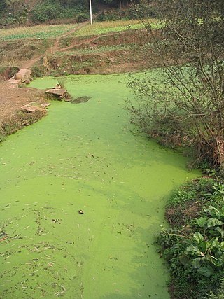
An algal bloom or algae bloom is a rapid increase or accumulation in the population of algae in freshwater or marine water systems. It is often recognized by the discoloration in the water from the algae's pigments. The term algae encompasses many types of aquatic photosynthetic organisms, both macroscopic multicellular organisms like seaweed and microscopic unicellular organisms like cyanobacteria. Algal bloom commonly refers to the rapid growth of microscopic unicellular algae, not macroscopic algae. An example of a macroscopic algal bloom is a kelp forest.
Eutrophication is the process by which an entire body of water, or parts of it, becomes progressively enriched with minerals and nutrients, particularly nitrogen and phosphorus. It has also been defined as "nutrient-induced increase in phytoplankton productivity". Water bodies with very low nutrient levels are termed oligotrophic and those with moderate nutrient levels are termed mesotrophic. Advanced eutrophication may also be referred to as dystrophic and hypertrophic conditions. Eutrophication can affect freshwater or salt water systems. In freshwater ecosystems it is almost always caused by excess phosphorus. In coastal waters on the other hand, the main contributing nutrient is more likely to be nitrogen, or nitrogen and phosphorus together. This depends on the location and other factors.

Limnology is the study of inland aquatic ecosystems. The study of limnology includes aspects of the biological, chemical, physical, and geological characteristics of fresh and saline, natural and man-made bodies of water. This includes the study of lakes, reservoirs, ponds, rivers, springs, streams, wetlands, and groundwater. Water systems are often categorized as either running (lotic) or standing (lentic).

Lake Okeechobee, also known as Florida's Inland Sea, is the largest freshwater lake in the U.S. state of Florida. It is the tenth largest natural freshwater lake among the 50 states of the United States and the second-largest natural freshwater lake contained entirely within the contiguous 48 states, after Lake Michigan.

The epilimnion or surface layer is the top-most layer in a thermally stratified lake. It sits above the deeper metalimnion and hypolimnion. It is typically warmer and has a higher pH and higher dissolved oxygen concentration than the hypolimnion.

A thermocline A distinct layer based on temperature within a large body of fluid A gradiant of distinct temperature differences associated with depth. In the ocean, the thermocline divides the upper mixed layer from the calm deep water below.

The spring bloom is a strong increase in phytoplankton abundance that typically occurs in the early spring and lasts until late spring or early summer. This seasonal event is characteristic of temperate North Atlantic, sub-polar, and coastal waters. Phytoplankton blooms occur when growth exceeds losses, however there is no universally accepted definition of the magnitude of change or the threshold of abundance that constitutes a bloom. The magnitude, spatial extent and duration of a bloom depends on a variety of abiotic and biotic factors. Abiotic factors include light availability, nutrients, temperature, and physical processes that influence light availability, and biotic factors include grazing, viral lysis, and phytoplankton physiology. The factors that lead to bloom initiation are still actively debated.
Lake stratification is the tendency of lakes to form separate and distinct thermal layers during warm weather. Typically stratified lakes show three distinct layers, the Epilimnion comprising the top warm layer, the thermocline : the middle layer, which may change depth throughout the day, and the colder Hypolimnion extending to the floor of the lake.
In biological oceanography, critical depth is defined as a hypothetical surface mixing depth where phytoplankton growth is precisely matched by losses of phytoplankton biomass within the depth interval. This concept is useful for understanding the initiation of phytoplankton blooms.

A lake ecosystem or lacustrine ecosystem includes biotic (living) plants, animals and micro-organisms, as well as abiotic (non-living) physical and chemical interactions. Lake ecosystems are a prime example of lentic ecosystems, which include ponds, lakes and wetlands, and much of this article applies to lentic ecosystems in general. Lentic ecosystems can be compared with lotic ecosystems, which involve flowing terrestrial waters such as rivers and streams. Together, these two ecosystems are examples of freshwater ecosystems.

Thin layers are concentrated aggregations of phytoplankton and zooplankton in coastal and offshore waters that are vertically compressed to thicknesses ranging from several centimeters up to a few meters and are horizontally extensive, sometimes for kilometers. Generally, thin layers have three basic criteria: 1) they must be horizontally and temporally persistent; 2) they must not exceed a critical threshold of vertical thickness; and 3) they must exceed a critical threshold of maximum concentration. The precise values for critical thresholds of thin layers has been debated for a long time due to the vast diversity of plankton, instrumentation, and environmental conditions. Thin layers have distinct biological, chemical, optical, and acoustical signatures which are difficult to measure with traditional sampling techniques such as nets and bottles. However, there has been a surge in studies of thin layers within the past two decades due to major advances in technology and instrumentation. Phytoplankton are often measured by optical instruments that can detect fluorescence such as LIDAR, and zooplankton are often measured by acoustic instruments that can detect acoustic backscattering such as ABS. These extraordinary concentrations of plankton have important implications for many aspects of marine ecology, as well as for ocean optics and acoustics. Zooplankton thin layers are often found slightly under phytoplankton layers because many feed on them. Thin layers occur in a wide variety of ocean environments, including estuaries, coastal shelves, fjords, bays, and the open ocean, and they are often associated with some form of vertical structure in the water column, such as pycnoclines, and in zones of reduced flow.
Monomictic lakes are holomictic lakes that mix from top to bottom during one mixing period each year. Monomictic lakes may be subdivided into cold and warm types.

The Trophic State Index (TSI) is a classification system designed to rate water bodies based on the amount of biological productivity they sustain. Although the term "trophic index" is commonly applied to lakes, any surface water body may be indexed.
The deep chlorophyll maximum (DCM), also called the subsurface chlorophyll maximum, is the region below the surface of water with the maximum concentration of chlorophyll. The DCM generally exists at the same depth as the nutricline, the region of the ocean where the greatest change in the nutrient concentration occurs with depth.

A harmful algal bloom (HAB) is an algal bloom that causes negative impacts to other organisms by production of natural algae-produced toxins, mechanical damage to other organisms, or by other means. HABs are sometimes defined as only those algal blooms that produce toxins, and sometimes as any algal bloom that can result in severely lower oxygen levels in natural waters, killing organisms in marine or fresh waters. Blooms can last from a few days to many months. After the bloom dies, the microbes that decompose the dead algae use up more of the oxygen, generating a "dead zone" which can cause fish die-offs. When these zones cover a large area for an extended period of time, neither fish nor plants are able to survive. Harmful algal blooms in marine environments are often called "red tides".
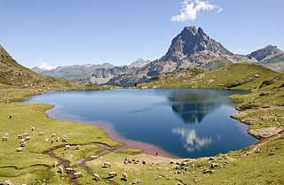
A lake is a naturally occurring, relatively large body of water localized in a basin surrounded by land, with much slower-moving flow than any inflow or outflow streams that serve to feed or drain the lake. Lakes lie completely on land and are separate from the ocean, although, but like the much larger oceans, they form part of the Earth's water cycle by serving as large standing water reservoirs. Most lakes are freshwater, but some are salt lakes with salinities even higher than that of seawater.

Freshwater biology is the scientific biological study of freshwater ecosystems and is a branch of limnology. This field seeks to understand the relationships between living organisms in their physical environment. These physical environments may include rivers, lakes, streams, ponds, lakes, reservoirs, or wetlands. Knowledge from this discipline is also widely used in industrial processes to make use of biological processes involved with sewage treatment and water purification. Water presence and flow is an essential aspect to species distribution and influences when and where species interact in freshwater environments.
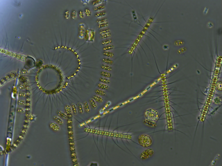
Freshwater phytoplankton is the phytoplankton occurring in freshwater ecosystems. It can be distinguished between limnoplankton, heleoplankton, and potamoplankton. They differ in size as the environment around them changes. They are affected negatively by the change in salinity in the water.

Lake metabolism represents a lake's balance between carbon fixation and biological carbon oxidation. Whole-lake metabolism includes the carbon fixation and oxidation from all organism within the lake, from bacteria to fishes, and is typically estimated by measuring changes in dissolved oxygen or carbon dioxide throughout the day.

Water clarity is a descriptive term for how deeply visible light penetrates through water. In addition to light penetration, the term water clarity is also often used to describe underwater visibility. Water clarity is one way that humans measure water quality, along with oxygen concentration and the presence or absence of pollutants and algal blooms.
