Related Research Articles

Stonehaven is a town in Scotland. It lies on Scotland's northeast coast and had a population of 11,602 at the 2011 Census. After the demise of the town of Kincardine, which was gradually abandoned after the destruction of its royal castle in the Wars of Independence, the Scottish Parliament made Stonehaven the successor county town of Kincardineshire. It is currently administered as part of the unitary authority of Aberdeenshire. Stonehaven had grown around an Iron Age fishing village, now the "Auld Toon", and expanded inland from the seaside. As late as the 16th century, old maps indicate the town was called Stonehyve,Stonehive, Timothy Pont also adding the alternative Duniness. It is known informally to locals as Stoney.

Kincardineshire, also known as the Mearns, is a historic county, registration county and lieutenancy area on the coast of northeast Scotland. It is bounded by Aberdeenshire on the north and west, and by Angus on the south.

Findon or Finnan is a fishing village eight miles south of Aberdeen, famous for originating the smoked haddock known as Finnan haddie. The Findon moor has a number of paths through it, many of which run along the cliffs. Deer can often be seen there. Nearby features include the Portlethen Moss Nature Reserve.

Fetteresso Castle is a 14th-century tower house, rebuilt in 1761 as a Scottish Gothic style Palladian manor, with clear evidence of prehistoric use of the site. It is situated immediately west of the town of Stonehaven in Kincardineshire, slightly to the west of the A90 dual carriageway. Other notable historic fortified houses or castles in this region are Dunnottar Castle, Muchalls Castle, Fiddes Castle, Cowie Castle and Monboddo House.

Raedykes is the site of a Roman marching camp located just over three miles northwest of Stonehaven, Aberdeenshire, Scotland. National Grid Reference NO 842902. It is designated as a scheduled monument. A marching camp was a temporary camp used mainly for overnight stops on a long route between more permanent forts, or as a temporary base while on campaign in hostile territory.
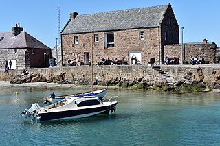
The Stonehaven Tolbooth is a late 16th-century stone building originally used as a courthouse and a prison in the town of Stonehaven, Aberdeenshire, Scotland. Constructed of local Old Red Sandstone, the prison probably attained its greatest note, when three local Episcopalian clergymen were imprisoned for holding services for more than nine people. Lying midway along the old north quay of the Stonehaven Harbour, the present day Tolbooth serves as a history museum with a restaurant on the floor above the ground floor. It is a category A listed building.

Glenbervie is located in the north east of Scotland in the Howe o' the Mearns, one mile from the village of Drumlithie and eight miles south of Stonehaven in Aberdeenshire. The river Bervie runs through the village. The rural area is the location of Glenbervie House and estate. The parish was formerly named Overbervie.
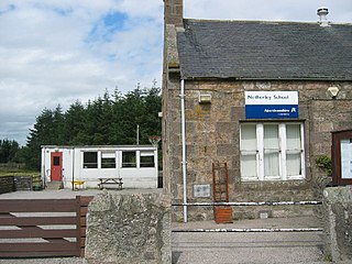
Netherley, Scotland is a village in Aberdeenshire, situated approximately five miles northwest of Stonehaven. Netherley is located in the Mounth area of the Grampian Highlands. At the eastern edge of Netherley is a significant wetland bog known as Red Moss. To the southwest of Netherley lie Meikle Carewe Hill and Curlethney Hill. At the south edge of Netherley is the peak of Craggie Cat.
The Burn of Elsick is a coastal stream in Aberdeenshire, Scotland that discharges to the North Sea. This watercourse drains primarily agricultural lands and enters the North Sea at Newtonhill.
The Causey Mounth is an ancient drovers' road over the coastal fringe of the Grampian Mountains in Aberdeenshire, Scotland. This route was developed as the main highway between Stonehaven and Aberdeen around the 12th century AD and it continued to function as the principal route connecting these two cities until the mid 20th century, when modern highway construction of the A90 road occurred in this area. There are extant paved and usable sections of this road over part of the alignment; however, many parts of the ancient route are no more than footpaths, and in some cases the road has vanished into agricultural fields. Constructed in the Middle Ages, the Causey Mounth was created as an elevated rock causeway to span many of the boggy areas such as the Portlethen Moss. A considerable portion of the alignment of the Causey Mounth is illustrated on the UK Ordnance Survey Map, although a large fraction of the route cannot be navigated by a conventional passenger vehicle.

Elsick House is a historic house in Kincardineshire, North-East Scotland. It is situated in an agricultural area about two miles from the North Sea near the town of Newtonhill; the Elsick Estate is situated within the watershed of the Burn of Elsick, a stream that traverses the estate. The house is located on the Elsick Estate, and is the present family seat of the Duke of Fife.
Cammachmore is a hamlet in the coastal region near the North Sea in Aberdeenshire. It lies slightly west of the A92 road and the ancient Causey Mounth passes through the community. Historic Elsick House is situated due west of Cammachmore. Other nearby historic features include Gillybrands, Saint Ternan's Church, Muchalls Castle and the Lairhillock Inn.
Burn of Monboys is a stream that rises in the Mounth, or eastern range of the Grampian Mountains, northwest of Stonehaven and south of Netherley, Aberdeenshire, Scotland. Monboys Burn is a tributary to the Cowie Water.
Kempstone Hill is a landform in Aberdeenshire, Scotland within the Mounth Range of the Grampian Mountains. The peak elevation of this mountain is 132 metres above mean sea level. This hill has been posited by Gabriel Jacques Surenne, Archibald Watt and C.Michael Hogan as the location for the noted Battle of Mons Graupius between the Romans and the indigenous Caledonians. The major Roman Camp of Raedykes is situated about three kilometres to the west. From Kempstone Hill there are fine views to the North Sea facing east and slightly to the north of Muchalls Castle. There is a UK trigpoint installation on Kempstone Hill.
Megray Hill is a low-lying coastal mountainous landform in Aberdeenshire, Scotland within the Mounth Range of the Grampian Mountains. The peak elevation of this mountain is 120 metres above mean sea level. This hill has been posited as a likely location for the noted Battle of Mons Graupius between the Romans and the indigenous Caledonians. The major Roman Camp of Raedykes is situated about three kilometres to the west. From Megray Hill there are expansive views to the North Sea facing east. The summit affords scenic views of the historic harbour of Stonehaven.

Normandykes is the site of a Roman marching camp 1 mile (1.6 km) to the southwest of Peterculter, City of Aberdeen, Scotland. The near-rectangular site, measuring approximately 860 by 510 metres, covers about 106 acres (43 ha) of the summit and eastern slopes of a hill overlooking the River Dee and the B9077 road further south. Aerial photographs for Normandykes have been archived between 1947 and 1976. The camp is about 6 miles (10 km), or less than half a day's march, north of the Raedykes camp. It is possible that the actual route taken would have entailed one day's march, over a route likely chosen to avoid the Red Moss, a virtually uncrossable bog near the present day village of Netherley. Normandykes was first excavated in the year 1935 by Richmond and MacIntyre; construction is thought to date to the Antonine or Severan periods.

Saint Ternan's Church is an Episcopal church in the Diocese of Brechin, near Muchalls in Aberdeenshire, Scotland.

The Chapel of St. Mary and St. Nathalan is a ruined chapel overlooking the North Sea immediately north of Stonehaven, in the Mearns of Scotland, along the northern shoreline of Stonehaven Bay. The founding of this Christian place of worship is associated with St. Nathalan. who lived circa 650 AD. The structure is alternatively known as Cowie Chapel. The chapel is at the point where the Highland Boundary Fault meets the sea and so is on the dividing line between the highlands and lowlands of Scotland.
The Hill of Muchalls is a coastal mountainous landform situated approximately 1.4 kilometres west of the Bridge of Muchalls in Aberdeenshire, Scotland within the Mounth Range of the Grampian Mountains. The peak elevation of this mountain is 120 metres above mean sea level. From Megray Hill there are expansive views to the North Sea facing east. The summit affords scenic vies of the historic harbour of Stonehaven.

Dunnottar Parish Church is a parish church of the Church of Scotland, serving Stonehaven in the south of Aberdeenshire, Scotland. It is within the Church of Scotland's Presbytery of Kincardine and Deeside. During 2020, the congregation united to the South Parish Church in Stonehaven to form Carronside Church of Scotland. On 3 June 2021, the Rev. Sarah Smith was inducted into the charge.
References
- ↑ United Kingdom Ordnance Survey Map Landranger 45, Stonehaven and Banchory, 1:50,000 scale, 2004
- ↑ Archibald Watt, Highways and Byways Round Stonehaven, Gourdas House Publishers, Aberdeen (1984)
- ↑ C. Michael Hogan, Elsick Mounth, Megalithic Portal, ed Andy Burnham (2007)
| | This Aberdeenshire location article is a stub. You can help Wikipedia by expanding it. |