The Barnard Island Group is a protected area in the Cassowary Coast Region, Queensland, Australia.
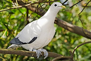
The Brook Islands National Park is a national park in Cassowary Coast Region, Queensland, Australia, 1246 km northwest of Brisbane, with an area of 0.9 km2. It was established in 1994 and comprises three islands which lie off the coast 7 km north-east of Cape Richards on Hinchinbrook Island and 30 km east of the nearest mainland town of Cardwell. The fourth island of the Brooks group, South Island, is not part of the national park but is protected by the Great Barrier Reef Marine Park Authority. Public access to the three islands in the national park is prohibited in order to protect breeding birds, especially the Torresian imperial-pigeon. The islands have no roads, walking tracks or other facilities. Popular activities in the waters around the islands are boating, snorkelling and fishing. The islands are managed by the Queensland Parks and Wildlife Service. The Park's IUCN category is II.

Tully is a town and locality in the Cassowary Coast Region, Queensland, Australia. It is adjacent to the Bruce Highway, approximately 140 kilometres (87 mi) south of Cairns by road and 210 kilometres (130 mi) north of Townsville. At the 2016 census, the population was 2,390. Tully is perhaps best known for being one of the wettest towns in Australia, and home to the 7.9 metre tall Golden Gumboot.

The Sunshine Coast is a peri-urban region in South East Queensland, Australia. It is the district defined in 1967 as "the area contained in the Shires of Landsborough, Maroochy and Noosa, but excluding Bribie Island". Located 100 km (62 mi) north of the centre of Brisbane in South East Queensland, on the Coral Sea coastline, its urban area spans approximately 60 km (37 mi) of coastline and hinterland from Pelican Waters to Tewantin.

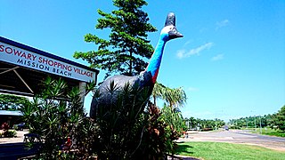
Mission Beach is a coastal town and locality in the Cassowary Coast Region, Queensland, Australia. In the 2016 census, the locality of Mission Beach had a population of 815 people.

Far North Queensland (FNQ) is the northernmost part of the Australian state of Queensland. Its largest city is Cairns and it is dominated geographically by Cape York Peninsula, which stretches north to the Torres Strait, and west to the Gulf Country. The waters of Torres Strait include the only international border in the area contiguous with the Australian mainland, between Australia and Papua New Guinea.
Kent Island is an island in the Australian state of Queensland located about 80 km North of Dunk Island and east of the Cowley Beach Training area and north of the South Barnard Islands. North west of Kent Island is Jessie Island, Hutchinson Island and Bresnahan Island.
Jessie Island is about 80 km north of Dunk Island and east of the Cowley Beach Training area and north of the South Barnard Islands.

The Cassowary Coast Region is a local government area in the Far North Queensland region of Queensland, Australia, south of Cairns and centred on the towns of Innisfail, Cardwell and Tully. It was created in 2008 from a merger of the Shire of Cardwell and the Shire of Johnstone.

Cowley Beach is a beach, coastal town and locality in the Cassowary Coast Region, Queensland, Australia. In the 2021 census, the locality of Cowley Beach had a population of 65 people.
The Cowley Beach Training Area (CBTA) is a military installation in Cowley Beach near Innisfail, Queensland, Australia. Military exercises are conducted there.
Lower Cowley is a rural locality in the Cassowary Coast Region, Queensland, Australia. In the 2016 census, Lower Cowley had a population of 64 people.
Wongaling Beach is a tropical beachside coastal town and locality in the Cassowary Coast Region, Queensland, Australia. In the 2016 census, the locality of Wongaling Beach had a population of 1,245 people.
No. 5 Branch is a rural locality in the Cassowary Coast Region, Queensland, Australia. In the 2016 census, the population of the locality was 9 people.

South Mission Beach is a coastal town and locality in the Cassowary Coast Region, Queensland, Australia. In the 2021 census, the locality of South Mission Beach had a population of 968 people.
Rungoo is a coastal locality in the Cassowary Coast Region, Queensland, Australia. In the 2021 census, Rungoo had a population of 11 people.
Tam O'Shanter is a rural locality in the Cassowary Coast Region, Queensland, Australia. In the 2021 census, Tam O'Shanter had "no people or a very low population".

Mamu is a rural locality in the Cassowary Coast Region, Queensland, Australia. In the 2021 census, Mamu had a population of 0 people.Mamu’s postcode is 4871.

Cowley is a rural locality in the Cassowary Coast Region, Queensland, Australia. In the 2021 census, Cowley had a population of 82 people.
Goolboo is a rural locality in the Cassowary Coast Region of Queensland, Australia. In the 2021 census, Goolboo had a population of 25 people.