Żywkowo is a village in the administrative district of Gmina Zabłudów, within Białystok County, Podlaskie Voivodeship, in north-eastern Poland. It lies approximately 8 kilometres (5 mi) south-east of Zabłudów and 24 km (15 mi) south-east of the regional capital Białystok.
Kalinówka Królewska is a village in the administrative district of Gmina Jasionówka, within Mońki County, Podlaskie Voivodeship, in north-eastern Poland. It lies approximately 5 kilometres (3 mi) north-west of Jasionówka, 12 km (7 mi) east of Mońki, and 36 km (22 mi) north of the regional capital Białystok.
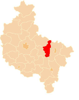
Gałczynek is a village in the administrative district of Gmina Orchowo, within Słupca County, Greater Poland Voivodeship, in west-central Poland. It lies approximately 4 kilometres (2 mi) south-west of Orchowo, 24 km (15 mi) north of Słupca, and 73 km (45 mi) east of the regional capital Poznań.
Doły is a village in the administrative district of Gmina Ostrowite, within Słupca County, Greater Poland Voivodeship, in west-central Poland. It lies approximately 6 kilometres (4 mi) south-west of Ostrowite, 11 km (7 mi) north-east of Słupca, and 74 km (46 mi) east of the regional capital Poznań.

Giewartów is a village in the administrative district of Gmina Ostrowite, within Słupca County, Greater Poland Voivodeship, in west-central Poland. It lies approximately 7 kilometres (4 mi) west of Ostrowite, 11 km (7 mi) north-east of Słupca, and 71 km (44 mi) east of the regional capital Poznań.
Gostuń is a village in the administrative district of Gmina Ostrowite, within Słupca County, Greater Poland Voivodeship, in west-central Poland. It lies approximately 4 kilometres (2 mi) south-west of Ostrowite, 12 km (7 mi) north-east of Słupca, and 74 km (46 mi) east of the regional capital Poznań.
Izdebno is a village in the administrative district of Gmina Ostrowite, within Słupca County, Greater Poland Voivodeship, in west-central Poland. It lies approximately 3 kilometres (2 mi) south-east of Ostrowite, 16 km (10 mi) north-east of Słupca, and 79 km (49 mi) east of the regional capital Poznań.
Jarotki is a village in the administrative district of Gmina Ostrowite, within Słupca County, Greater Poland Voivodeship, in west-central Poland. It lies approximately 2 kilometres (1 mi) east of Ostrowite, 17 km (11 mi) north-east of Słupca, and 79 km (49 mi) east of the regional capital Poznań.
Kania is a village in the administrative district of Gmina Ostrowite, within Słupca County, Greater Poland Voivodeship, in west-central Poland. It lies approximately 6 kilometres (4 mi) north of Ostrowite, 20 km (12 mi) north-east of Słupca, and 78 km (48 mi) east of the regional capital Poznań.
Kąpiel is a village in the administrative district of Gmina Ostrowite, within Słupca County, Greater Poland Voivodeship, in west-central Poland. It lies approximately 3 kilometres (2 mi) south-west of Ostrowite, 14 km (9 mi) north-east of Słupca, and 76 km (47 mi) east of the regional capital Poznań.
Kosewo is a village in the administrative district of Gmina Ostrowite, within Słupca County, Greater Poland Voivodeship, in west-central Poland. It lies approximately 8 kilometres (5 mi) west of Ostrowite, 13 km (8 mi) north-east of Słupca, and 71 km (44 mi) east of the regional capital Poznań.
Mieczownica is a village in the administrative district of Gmina Ostrowite, within Słupca County, Greater Poland Voivodeship, in west-central Poland. It lies approximately 6 kilometres (4 mi) west of Ostrowite, 11 km (7 mi) north-east of Słupca, and 72 km (45 mi) east of the regional capital Poznań.
Naprusewo is a village in the administrative district of Gmina Ostrowite, within Słupca County, Greater Poland Voivodeship, in west-central Poland. It lies approximately 14 kilometres (9 mi) north-east of Słupca and 73 km (45 mi) east of the regional capital Poznań.
Ostrowite is a village in Słupca County, Greater Poland Voivodeship, in west-central Poland. It is the seat of the gmina called Gmina Ostrowite. It lies approximately 16 kilometres (10 mi) north-east of Słupca and 78 km (48 mi) east of the regional capital Poznań.
Przecław is a village in the administrative district of Gmina Ostrowite, within Słupca County, Greater Poland Voivodeship, in west-central Poland. It lies approximately 2 kilometres (1 mi) south of Ostrowite, 15 km (9 mi) north-east of Słupca, and 78 km (48 mi) east of the regional capital Poznań.
Sienno is a village in the administrative district of Gmina Ostrowite, within Słupca County, Greater Poland Voivodeship, in west-central Poland. It lies approximately 4 kilometres (2 mi) west of Ostrowite, 13 km (8 mi) north-east of Słupca, and 74 km (46 mi) east of the regional capital Poznań.
Siernicze Wielkie is a village in the administrative district of Gmina Ostrowite, within Słupca County, Greater Poland Voivodeship, in west-central Poland. It lies approximately 17 kilometres (11 mi) north-east of Słupca and 75 km (47 mi) east of the regional capital Poznań.
Skrzynka Mała is a village in the administrative district of Gmina Ostrowite, within Słupca County, Greater Poland Voivodeship, in west-central Poland. It lies approximately 7 kilometres (4 mi) north of Ostrowite, 19 km (12 mi) north-east of Słupca, and 75 km (47 mi) east of the regional capital Poznań.
Szyszłowo is a village in the administrative district of Gmina Ostrowite, within Słupca County, Greater Poland Voivodeship, in west-central Poland. It lies approximately 13 kilometres (8 mi) north-east of Słupca and 77 km (48 mi) east of the regional capital Poznań.
Tomiszewo is a village in the administrative district of Gmina Ostrowite, within Słupca County, Greater Poland Voivodeship, in west-central Poland. It lies approximately 14 kilometres (9 mi) north-east of Słupca and 72 km (45 mi) east of the regional capital Poznań.