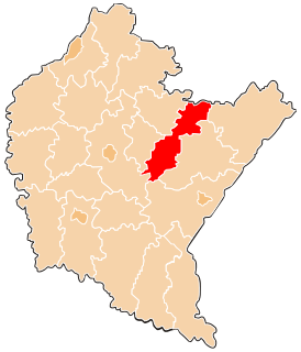
Kańczuga is a town in Przeworsk County, Subcarpathian Voivodeship, Poland, with a population of 3,187 inhabitants (02.06.2009). The town was an early centre of the Polish automobile industry. Buses based on Fiat 621R and used in Kraków had bodywork fitted in Kańczuga. Today the town is known for restoration of old SAABs.
Gmina Gać is a rural gmina in Przeworsk County, Subcarpathian Voivodeship, in south-eastern Poland. Its seat is the village of Gać, which lies approximately 12 kilometres (7 mi) south-west of Przeworsk and 26 km (16 mi) east of the regional capital Rzeszów.
Gmina Jawornik Polski is a rural gmina in Przeworsk County, Subcarpathian Voivodeship, in south-eastern Poland. Its seat is the village of Jawornik Polski, which lies approximately 26 kilometres (16 mi) south-west of Przeworsk and 25 km (16 mi) south-east of the regional capital Rzeszów.
Gmina Zarzecze is a rural gmina in Przeworsk County, Subcarpathian Voivodeship, in south-eastern Poland. Its seat is the village of Zarzecze, which lies approximately 10 kilometres (6 mi) south of Przeworsk and 39 km (24 mi) east of the regional capital Rzeszów.

Hadle Szklarskie is a village in the administrative district of Gmina Jawornik Polski, within Przeworsk County, Subcarpathian Voivodeship, in south-eastern Poland. It lies approximately 22 kilometres (14 mi) south-west of Przeworsk and 25 km (16 mi) south-east of the regional capital Rzeszów.
Bóbrka Kańczucka is a village in the administrative district of Gmina Kańczuga, within Przeworsk County, Subcarpathian Voivodeship, in south-eastern Poland. It lies approximately 8 kilometres (5 mi) south-east of Kańczuga, 12 km (7 mi) south of Przeworsk, and 36 km (22 mi) east of the regional capital Rzeszów.
Chodakówka is a village in the administrative district of Gmina Kańczuga, within Przeworsk County, Subcarpathian Voivodeship, in south-eastern Poland. It lies approximately 8 kilometres (5 mi) south-west of Kańczuga, 18 km (11 mi) south-west of Przeworsk, and 24 km (15 mi) east of the regional capital Rzeszów.
Krzeczowice is a village in the administrative district of Gmina Kańczuga, within Przeworsk County, Subcarpathian Voivodeship, in south-eastern Poland. It lies approximately 5 kilometres (3 mi) south-east of Kańczuga, 10 km (6 mi) south of Przeworsk, and 33 km (21 mi) east of the regional capital Rzeszów.
Łopuszka Mała is a village in the administrative district of Gmina Kańczuga, within Przeworsk County, Subcarpathian Voivodeship, in south-eastern Poland. It lies approximately 5 kilometres (3 mi) south-east of Kańczuga, 13 km (8 mi) south-west of Przeworsk, and 32 km (20 mi) east of the regional capital Rzeszów.
Łopuszka Wielka is a village in the administrative district of Gmina Kańczuga, within Przeworsk County, Subcarpathian Voivodeship, in south-eastern Poland. It lies approximately 8 kilometres (5 mi) south of Kańczuga, 17 km (11 mi) south-west of Przeworsk, and 31 km (19 mi) east of the regional capital Rzeszów.
Medynia Kańczucka is a village in the administrative district of Gmina Kańczuga, within Przeworsk County, Subcarpathian Voivodeship, in south-eastern Poland. It lies approximately 8 kilometres (5 mi) south of Kańczuga, 18 km (11 mi) south-west of Przeworsk, and 29 km (18 mi) south-east of the regional capital Rzeszów.
Niżatyce is a village in the administrative district of Gmina Kańczuga, within Przeworsk County, Subcarpathian Voivodeship, in south-eastern Poland. It lies approximately 3 kilometres (2 mi) south-east of Kańczuga, 11 km (7 mi) south-west of Przeworsk, and 30 km (19 mi) east of the regional capital Rzeszów.
Pantalowice is a village in the administrative district of Gmina Kańczuga, within Przeworsk County, Subcarpathian Voivodeship, in south-eastern Poland. It lies approximately 7 kilometres (4 mi) south-east of Kańczuga, 14 km (9 mi) south of Przeworsk, and 34 km (21 mi) east of the regional capital Rzeszów.
Rączyna is a village in the administrative district of Gmina Kańczuga, within Przeworsk County, Subcarpathian Voivodeship, in south-eastern Poland. It lies approximately 10 kilometres (6 mi) south of Kańczuga, 18 km (11 mi) south of Przeworsk, and 35 km (22 mi) east of the regional capital Rzeszów.
Siedleczka is a village in the administrative district of Gmina Kańczuga, within Przeworsk County, Subcarpathian Voivodeship, in south-eastern Poland. It lies approximately 5 kilometres (3 mi) south-west of Kańczuga, 15 km (9 mi) south-west of Przeworsk, and 27 km (17 mi) east of the regional capital Rzeszów.
Sietesz is a village in the administrative district of Gmina Kańczuga, within Przeworsk County, Subcarpathian Voivodeship, in south-eastern Poland. It lies approximately 6 kilometres (4 mi) west of Kańczuga, 16 km (10 mi) south-west of Przeworsk, and 25 km (16 mi) east of the regional capital Rzeszów.
Wola Rzeplińska is a village in the administrative district of Gmina Kańczuga, within Przeworsk County, Subcarpathian Voivodeship, in south-eastern Poland. It lies approximately 13 kilometres (8 mi) south of Kańczuga, 22 km (14 mi) south of Przeworsk, and 33 km (21 mi) south-east of the regional capital Rzeszów.
Żuklin is a village in the administrative district of Gmina Kańczuga, within Przeworsk County, Subcarpathian Voivodeship, in south-eastern Poland. It lies approximately 5 kilometres (3 mi) south-east of Kańczuga, 10 km (6 mi) south of Przeworsk, and 33 km (21 mi) east of the regional capital Rzeszów.