The Eifel is a low mountain range in western Germany, eastern Belgium and northern Luxembourg. It occupies parts of southwestern North Rhine-Westphalia, northwestern Rhineland-Palatinate and the southern area of the German-speaking Community of Belgium.
Vulkaneifel is a district (Kreis) in the northwest of the state Rhineland-Palatinate, Germany. It is the least densely populated district in the state and the fourth most sparsely populated district in Germany. The administrative centre of the district is in Daun. Neighboring districts are Euskirchen, Ahrweiler, Mayen-Koblenz, Cochem-Zell, Bernkastel-Wittlich, and Bitburg-Prüm.

Daun is a town in the Vulkaneifel district in Rhineland-Palatinate, Germany. It is the district seat and also the seat of the Verbandsgemeinde of Daun.

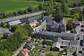
Gerolstein is a town in the Vulkaneifel district of Rhineland-Palatinate, Germany. Gerolstein is a local municipality of the Verbandsgemeinde Gerolstein. It has been approved as a Luftkurort.

Densborn is an Ortsgemeinde – a municipality belonging to a Verbandsgemeinde, a kind of collective municipality – in the Vulkaneifel district in Rhineland-Palatinate, Germany. It belongs to the Verbandsgemeinde of Gerolstein, whose seat is in the like-named town.

Jünkerath is an Ortsgemeinde – a municipality belonging to a Verbandsgemeinde, a kind of collective municipality – in the Vulkaneifel district in Rhineland-Palatinate, Germany. It was th seat of the former Verbandsgemeinde of Obere Kyll.

Kalenborn-Scheuern is an Ortsgemeinde – a municipality belonging to a Verbandsgemeinde, a kind of collective municipality – in the Vulkaneifel district in Rhineland-Palatinate, Germany. It belongs to the Verbandsgemeinde of Gerolstein, whose seat is in the like-named town.

Mürlenbach is an Ortsgemeinde – a municipality belonging to a Verbandsgemeinde, a kind of collective municipality – in the Vulkaneifel district in Rhineland-Palatinate, Germany. It belongs to the Verbandsgemeinde of Gerolstein, whose seat is in the like-named town.

Stadtkyll is an Ortsgemeinde – a municipality belonging to a Verbandsgemeinde, a kind of collective municipality – in the Vulkaneifel district in Rhineland-Palatinate, Germany. It belongs to the Verbandsgemeinde of Gerolstein, whose seat is in the municipality of Gerolstein. Stadtkyll is a state-recognized climatic spa (Luftkurort).

Kriebstein Castle is a castle in Kriebstein near the town of Waldheim in the German state of Saxony.

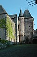
The ruins of the Thurant Castle stand on a wide slate hill spur above the villages of Alken on the Moselle in Germany. The castle is in the district of Mayen-Koblenz in Rhineland-Palatinate and belongs to the spur castle type. Vine gardens on the sunniest slope.
The Wildenburg lies in the North Rhine-Westphalian part of the Eifel Mountains in the national park district of Hellenthal in the German county of Euskirchen.
Dollendorf is a village in the municipality of Blankenheim in the district of Euskirchen in the German state of North Rhine-Westphalia. It gives its name to the surrounding limestone depression (Kalkmulde).
The Alte Burg near Lommersdorf in the municipality of Blankenheim in the county of Euskirchen in the German state of North Rhine-Westphalia is a levelled mediaeval castle site.

The ruins of Ramstein Castle stand on a 182-metre-high, Bunter sandstone rock on the edge of the Meulenwald forest in the lower, steep-sided Kyll valley near Kordel in the German state of Rhineland-Palatinate. It stands 9 kilometres (5.6 mi) north of Trier and the same east of Luxembourg.
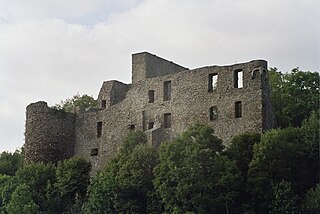
Virneburg Castle is a ruined hill castle on a slate hill, 430 m above sea level (NHN), around which the Nitzbach stream flows. It stands above the village of Virneburg in the county of Mayen-Koblenz in the German state of Rhineland-Palatinate.

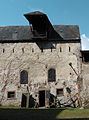
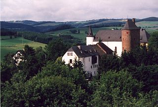
The Kasselburg is a ruined hill castle on a 490-metre-high basalt massif in Pelm near Gerolstein in the county of Vulkaneifel in the German state of Rhineland-Palatinate.

Burg Dagestein is a castle in the city of Vilseck in the Oberpfalz region of northeastern Bavaria, Germany.