Related Research Articles

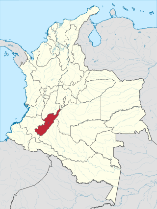
Department of Cundinamarca is one of the departments of Colombia. Its area covers 22,623 square kilometres (8,735 sq mi) and it has a population of 2,919,060 as of 2018. It was created on August 5, 1886, under the constitutional terms presented on the same year. Cundinamarca is located in the center of Colombia.
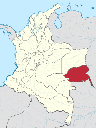
Guainía is a department of Eastern Colombia. It is in the east of the country, bordering Venezuela and Brazil. Its capital is Inírida. In 1963 Guainía was split off from Vaupés department. The northern part and the Inírida River are included in the Orinoco basin; the rest is part of the Amazon basin. The Guaviare River is the main area of colonization; many colonos come from the Colombian Andean zone, most of them from Boyacá. They are followed by the llaneros, people from the Eastern plains (Llanos). The population is mainly composed of Amerindians, and the largest ethnic groups are the Puinaves and the curripacos. There are a total of 24 ethnic groups in the department; many of them speak four Indigenous languages besides Spanish and Portuguese.
Huila is one of the departments of Colombia. It is located in the southwest of the country, and its capital is Neiva.

Vaupés is a department of Southeastern Colombia in the jungle covered Amazonía Region. It is located in the southeast part of the country, bordering Brazil to the east, the department of Amazonas to the south, Caquetá to the west, and Guaviare, and Guainía to the north; covering a total area of 54,135 km2. Its capital is the town of Mitú. As of 2018, the population was 40,797, making it the least populous department in Colombia.

Soacha is an autonomous municipality of the department of Cundinamarca in Colombia, and part of the Metropolitan Area of Bogotá. It has an important industrial zone and is home to mostly working-class families. Soacha borders Bojacá and Mosquera to the north, Sibaté and Pasca to the south, to the east the capital Bogotá and to the west Granada and San Antonio del Tequendama.

Inírida, formerly Puerto Inírida, is the capital city, and a municipality, of the department of Guainía in Colombia. It was established in 1963 on the site of the small village of Obando, at the time in the municipality of San Felipe. The municipality was renamed in 1974. The municipal population of 31,514 is mostly indigenous and accounts for about a third of the department's population.

Envigado is a city and municipality southeast of Medellín, Colombia in the department of Antioquia. It is located in the Metropolitan Area of the Aburrá Valley. It borders El Poblado, Medellín to the north, Sabaneta to the south, El Retiro and Caldas to the east, and Itagüí to the west.

Itagüí is a city and municipality of Colombia, located in the south of the Aburrá Valley in the Antioquia Department. It is part of the Metropolitan Area of the Aburrá Valley.

Venecia is a town and municipality in Antioquia Department, Colombia. According to the 2018 census, the population comprised 10,280 people.

Rionegro is a city and municipality in Antioquia Department, Colombia, located in the subregion of Eastern Antioquia. The official name of the city is "Ciudad Santiago de Arma de Rionegro". Rio Negro means "Black River" in Spanish, as the city received its name after a river that looks black because of the shadows cast by trees. The river traverses the city and it is the most prominent geographical feature of the municipality. Rionegro is also sometimes called the Cuna de la democracia as it was one of the most important cities during the era of the Colombia's struggle for independence and the 1863 constitution was written in the city.

Sabaneta is a municipality of Colombia, located in the Aburrá Valley of the Antioquia department. It is bordered on the north by the municipalities of La Estrella, Itagüí and Envigado, on the east by Envigado, on the south by Caldas, and on the west by La Estrella.

San Luis is a municipality in Colombia, located in the department of Antioquia. It is limited in the north by the municipalities of San Carlos and Puerto Nare, in the east by the municipality of Puerto Triunfo, in the south by the municipality of San Francisco and in the west by the municipalities of Cocorná and Granada.

Corregimiento is a term used in Colombia to define a subdivision of Colombian municipalities. According to the Colombian Constitution of 1991 and Decree 2274 of October 4, 1991, a corregimiento is an internal part of a Department or province, which includes a population core. It is usually less populated than a municipality..

Cota is a municipality and town of Colombia in the Central Savanna Province of the department of Cundinamarca. Cota is part of the metropolitan area of Colombian capital Bogotá which centre is 26 kilometres (16 mi) away. The urban centre of Cota is located at an altitude of 2,566 metres (8,419 ft) and the municipality borders Chía in the north, Funza in the south, Suba, part of Bogotá in the east and Tenjo in the west.
Girardot is a municipality and town of Colombia in the department of Cundinamarca. It is the second most important city of Cundinamarca according to its production. It is home to a number of recreational and vacational spots, mainly visited by people from Bogotá, as it is located at two hours drive from the city but enjoys a tropical climate. The municipality had a population of 109,792, and form a small metropolitan area together with the neighbouring municipalities of Flandes and Ricaurte.

La Calera is a municipality and town of Colombia in the Guavio Province, part of the department of Cundinamarca. La Calera is a common weekend destination, mainly for the many restaurants, as it is approximately 18 kilometres (11 mi) over land from Bogotá, the capital city of Colombia. La Calera is located in the Eastern Ranges of the Colombian Andes, east of the capital and overlooking part of it. La Calera borders Guasca, Sopó and Chía in the north, Guasca and Junín in the east, Bogotá in the west and Choachí and Fómeque in the south.

The Metropolitan Area of the Aburrá Valley is the second most important and populated metropolitan area in Colombia. The region is made up of ten municipalities, Medellín (Colombia) being the most important, largest and the capital city of the Antioquia Department.

Metropolitan Area of Bogotá is the metropolitan area of the Colombian capital city of Bogotá, usually used for statistical analysis or technical use. It is not a formal administrative division and its limits are therefore not defined.

Planura is a municipality in the west of the Brazilian state of Minas Gerais. As of 2020 the population was 12,292 in a total area of 318 km2. It became a municipality in 1962.
Regional and municipal elections were held on Sunday, 27 October 2019 in Colombia to elect the governors of the 32 departments, deputies to departmental assemblies, mayors of 1,102 municipalities, municipal councillors and aldermen on local administrative boards.
References
- ↑ "Colombia: Administrative Division (Departments and Municipalities) - Population Statistics, Charts and Map". www.citypopulation.de. Retrieved 2024-02-01.