Related Research Articles

Clay County is a county located in the far western part of U.S. state North Carolina. As of the 2020 census, the county population was 11,089. The county seat is Hayesville.

North Carolina State University is a public land-grant research university in Raleigh, North Carolina, United States. Founded in 1887 and part of the University of North Carolina system, it is the largest university in the Carolinas. The university forms one of the corners of the Research Triangle together with Duke University in Durham and the University of North Carolina at Chapel Hill. It is classified among "R1: Doctoral Universities – Very high research activity".

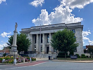
Polk County is a county located in the U.S. state of North Carolina. As of the 2020 census, the population was 19,328. Its county seat is Columbus.

Cumberland County is a county located in the U.S. state of North Carolina. As of the 2020 census, the population was 334,728, making it the fifth-most populous county in North Carolina. Its county seat is Fayetteville. Cumberland County is part of the Fayetteville, NC Metropolitan Statistical Area.
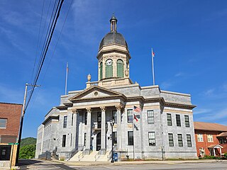
Cherokee County is the westernmost county in the U.S. state of North Carolina. It borders Tennessee to its west and Georgia to its south. As of the 2020 census, the population was 28,774. The county seat is Murphy.
Alamance County is a county in North Carolina. As of the 2020 census, the population was 171,415. Its county seat is Graham. Formed in 1849 from Orange County to the east, Alamance County has been the site of significant historical events, textile manufacturing, and agriculture.

Salisbury is a city in the Piedmont region of North Carolina, United States; it has been the county seat of Rowan County since 1753 when its territory extended to the Mississippi River. Located 25 miles (40 km) northeast of Charlotte and within its metropolitan area, the town has attracted a growing population. The 2020 census shows 35,580 residents.

Apex is a town in Wake County, North Carolina, United States. At its southern border, Apex encompasses the community of Friendship. In 1994, the downtown area was designated a historic district, and the Apex train depot, built in 1867, is designated a Wake County landmark. The depot location marks the highest point on the old Chatham Railroad, hence the town's name. The town motto is "The Peak of Good Living".

Elkin is a town in Surry and Wilkes counties in the U.S. state of North Carolina, along the Yadkin River. Elkin shares its name with the surrounding township of Elkin Township. The population was 4,122 at the time of the 2020 census.

Interstate 95 (I-95) is a part of the Interstate Highway System that runs along the East Coast of the United States from Miami, Florida, to the Canada–United States border at Houlton, Maine. In the state of North Carolina, the route runs for 181.36 miles (291.87 km) from the South Carolina border near Rowland to the Virginia border near Pleasant Hill. The highway serves the cities of Lumberton, Fayetteville, Wilson, Rocky Mount, and Roanoke Rapids. The route goes through a mostly rural area of the state, avoiding most of the major metro areas of North Carolina. It forms the informal border between the Piedmont and Atlantic Plain regions of the state.

The North Carolina Highway System consists of a vast network of Interstate, United States, and state highways, managed by the North Carolina Department of Transportation. North Carolina has the second largest state maintained highway network in the United States because all roads in North Carolina are maintained by either municipalities or the state. Since counties do not maintain roads, there is no such thing as a "county road" within the state.

North Carolina Highway 10 (NC 10) is a primary state highway in the U.S. state of North Carolina. Originally established as the state's central highway, from Murphy to Beaufort, it now serves to connect the city of Newton with the nearby communities and towns in the foothills region.
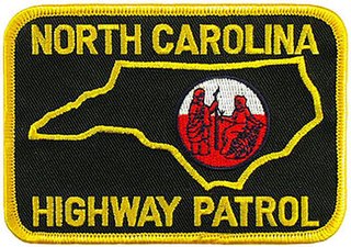
The North Carolina State Highway Patrol (NCSHP) is the highway patrol agency for North Carolina which has no per-se "state police" agency. The Patrol has jurisdiction anywhere in the state except for federal or military installations and on the Cherokee Indian Reservation or on Cherokee outlying lands in the western mountains. NCSHP personnel at times conduct formations, inspections, honor guard activities. The primary mission of the North Carolina State Highway Patrol is to ensure safe and efficient transportation on the streets and highways, reduce crime, protect against terrorism, enforce motor vehicle laws, and respond to natural and man-made disasters.
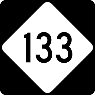
North Carolina Highway 133 (NC 133) is a primary state highway in the U.S. state of North Carolina. It traverses 46.6 miles (75.0 km) from Oak Island Drive in Oak Island to NC 210 in Bells Crossroads. The route serves communities such as Southport, Belville, Leland, Wilmington, and Castle Hayne. Additionally, NC 133 serves as an entry point for Military Ocean Terminal Sunny Point located to its east. Much of NC 133 runs parallel to the Cape Fear River and Brunswick River between Southport and Belville. West of Wilmington, NC 133 runs concurrently with U.S. Route 17 (US 17), US 74, and US 76. The road follows another concurrency along US 74 and US 421, west of Downtown Wilmington, and crosses into New Hanover County on the Isabel Holmes Bridge. North of Wilmington, NC 133 exits to the north, serving several suburban communities north of Wilmington. NC 133 runs concurrently with US 117 through Castle Hayne, before bearing northwest toward Bells Crossroads.
The Greenville and Raleigh Plank Road was a corporate Plank road from Greenville, North Carolina to the state capital in Raleigh, North Carolina. Established in 1850, it formed a "farmer's railroad" between the two cities in Eastern North Carolina as part of the Plank Road Boom. It allowed for fairly easy transportation for farm products and manufactured goods inland to the steamboat landing in Greenville.

The North Carolina Highway Historical Marker Program was created by the North Carolina General Assembly in 1935. Since that time over 1600 black and silver markers have been placed along numbered North Carolina highways throughout the state. Each one has a brief description of a fact relevant to state history, and is located near a place related to that fact.