Related Research Articles

Bodmin Moor is a granite moorland in north-eastern Cornwall, England. It is 208 square kilometres (80 sq mi) in size, and dates from the Carboniferous period of geological history. It includes Brown Willy, the highest point in Cornwall, and Rough Tor, a slightly lower peak. Many of Cornwall's rivers have their sources here. It has been inhabited since at least the Neolithic era, when primitive farmers started clearing trees and farming the land. They left their megalithic monuments, hut circles and cairns, and the Bronze Age culture that followed left further cairns, and more stone circles and stone rows. By medieval and modern times, nearly all the forest was gone and livestock rearing predominated.
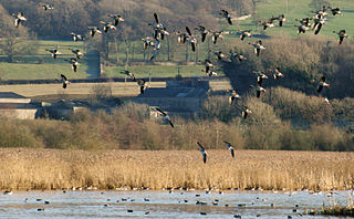
Leighton Moss RSPB reserve is a nature reserve in Lancashire, England, which has been in the care of the Royal Society for the Protection of Birds since 1964. It is situated at Silverdale near Carnforth, on the edge of Morecambe Bay and in the Arnside and Silverdale Area of Outstanding Natural Beauty.

The Duddon Estuary is the sandy, gritty estuary of the River Duddon that lies between Morecambe Bay and the North Lonsdale coast.
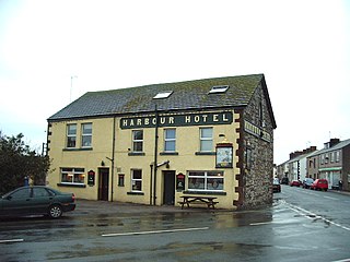
Haverigg is a village on the south-west coast of Cumbria, England, historically part of the county of Cumberland. In 2001 it had a population of 1,791 in 548 households, increasing in 2011 to a population of 1,849 in 549 Households.

RSPB Dearne Valley Old Moor is an 89-hectare (220-acre) wetlands nature reserve in the Dearne Valley near Barnsley, South Yorkshire, run by the Royal Society for the Protection of Birds (RSPB). It lies on the junction of the A633 and A6195 roads and is bordered by the Trans Pennine Trail long-distance path. Following the end of coal mining locally, the Dearne Valley had become a derelict post-industrial area, and the removal of soil to cover an adjacent polluted site enabled the creation of the wetlands at Old Moor.

Hodbarrow RSPB Reserve is a nature reserve run by the Royal Society for the Protection of Birds on the edge of the Lake District National Park in Cumbria, England. It is on the Duddon Estuary near the town of Millom.
Arnside and Silverdale is an Area of Outstanding Natural Beauty in England, on the border between Lancashire and Cumbria, adjoining Morecambe Bay. One of the smallest AONBs, it covers 29 square miles (75 km2) between the Kent Estuary, the River Keer and the A6 road. It was designated in 1972.
The Ch'ŏngch'ŏn is a river of North Korea having its source in the Rangrim Mountains of Chagang Province and emptying into the Yellow Sea at Sinanju. The river flows past Myohyang-san and through the city of Anju, South P'yŏngan Province. Its total length is 217 km (135 mi), and it drains a basin of 9,553 km2.
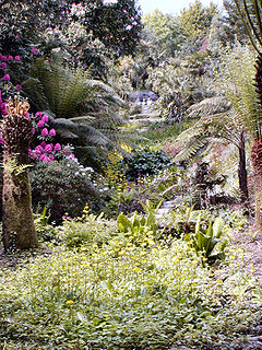
Cornwall is the county that forms the tip of the southwestern peninsula of England; this area has a mild and warm climate regulated by the Gulf Stream. The mild climate allows rich plant cover, such as palm trees in the far south and west of the county and in the Isles of Scilly, due to sub-tropical conditions in the summer.

The Souss-Massa National Park is a 33,800 hectare national park on the Atlantic coast of Morocco which was created in 1991. It lies between Agadir to the north and Sidi Ifni to the south and its centre is at 9°40'W 30°5'N. The estuary of the Oued Souss is the northern limit of the park, and that of the Oued Massa is near the southern end. 30,000 ha of land near Aglou, south of the park, is also included in the site because it is sometimes used as a feeding area by the northern bald ibis. The habitat is grazed steppe with dunes, beaches and wetlands. The soil is mainly sandy with some rockier areas.

The Hunter Estuary Wetlands comprise a group of associated wetlands at and near the mouth of the Hunter River in the city of Newcastle, New South Wales, Australia. Some 30 km2 of the wetlands has been recognised as being of international importance by designation under the Ramsar Convention. It was listed on 21 February 1984 as Ramsar site 287. A larger area of the wetlands has been identified by BirdLife International as an Important Bird Area (IBA). The wetlands are recognised as the most important area in New South Wales for waders, or shorebirds.

The Rubicon Estuary is an estuary on the central coast of northern Tasmania, south-eastern Australia, lying next to the town of Port Sorell.

The Amrok River estuary Important Bird Area comprises the North Korean part of the Amrok, or Yalu, estuary, with an area of 7,000 ha, abutting the border with China on the north-eastern coast of the Yellow Sea. The site has been identified by BirdLife International as an Important Bird Area (IBA) because it supports up to 20,000 waterbirds. Birds for which the site is significant include swan geese, Baikal teal, black-faced spoonbills, white-naped cranes, red-crowned cranes and Far Eastern curlews. Only 1000 ha of the site is protected in a nature reserve.

The Orangchon River estuary Important Bird Area comprises the 2500 ha estuary of the Orangchon River where it flows into the Sea of Japan in North Hamgyong Province on the north-eastern coast of North Korea.. The site has been identified by BirdLife International as an Important Bird Area (IBA) because it supports several waterbird species. Birds for which the site is significant include swan geese, bean geese, greater white-fronted geese, scaly-sided mergansers, white-naped cranes, red-crowned cranes and dunlins. 1500 ha of the site is protected in a nature reserve.

The Ryonghung Gang estuary Important Bird Area comprises the 10,000 ha estuary of the Ryonghung River where it flows into the Sea of Japan in South Hamgyong Province on the eastern coast of North Korea. The site contains both estuarine waters and rice paddies. It has been identified by BirdLife International as an Important Bird Area (IBA) because it supports an overwintering population of red-crowned cranes.

Ŭllyul Kŭmsanp'o is an 800 ha wetland wildlife reserve on the north-eastern shore of the Yellow Sea, on the west coast of North Korea in Ŭllyul County, South Hwanghae Province south of the estuary of the Taedong River. The site forms the core of a 1400 ha Important Bird Area (IBA), identified as such by BirdLife International because, with adjacent rice paddies, it supports populations of migrating and wintering water and wetland birds. Species using the site include swan geese, whooper swans, black-faced spoonbills, Chinese egrets, red-crowned cranes and Nordmann's greenshanks. The IBA is threatened by agricultural intensification.

The Taedong River estuary Important Bird Area is an 11,500 ha site in southern South Pyongan Province of North Korea, where the Taedong River meets the Yellow Sea. It has been identified by BirdLife International as an Important Bird Area (IBA) because it supports populations of various waterbirds. These include swan geese, mute swans, whooper swans, Baikal teals, Steller's sea-eagles, red-crowned cranes and Saunders's gulls. The site comprises a range of wetlands including freshwater lakes, salt pans and rice paddies. Threats to the IBA include agricultural intensification and aquacultural development.
References
- ↑ "Bodmin Moor". Important Bird Areas factsheet. BirdLife International. 2013. Archived from the original on 30 June 2007. Retrieved 2013-04-19.
- ↑ "Important Bird and Biodiversity Area factsheet: Duddon Estuary". BirdLife International. Retrieved 2 September 2016.
- ↑ BirdLife International. "Important Bird Areas factsheet: Leighton Moss" . Retrieved 30 December 2012.
- Pritchard, D. E., S. D. Housden, G. P. Mudge, C. A. Galbraith and M. W. Pienkowski (Eds.) 1992 Important Bird Areas in the UK including the Channel Islands and the Isle of Man published by RSPB