Related Research Articles

Mount Mitchell,, is the highest peak of the Appalachian Mountains and the highest peak in mainland North America east of the Mississippi River. It is located near Burnsville in Yancey County, North Carolina in the Black Mountain subrange of the Appalachians about 19 miles (31 km) northeast of Asheville. It is protected by Mount Mitchell State Park and surrounded by the Pisgah National Forest. Mount Mitchell's elevation is 6,684 feet (2,037 m) above sea level. Mount Mitchell is ranked 31st by topographic isolation.
Midland is a town in southern Cabarrus County in the U.S. state of North Carolina. Located in the Charlotte region of North Carolina, Midland is a 30-minute commute to uptown Charlotte. The name of the town is derived from its location approximately halfway between Charlotte and Oakboro on the railroad line. The population was 3,073 at the 2010 census.

The United States National Climatic Data Center (NCDC), previously known as the National Weather Records Center (NWRC), in Asheville, North Carolina, was the world's largest active archive of weather data.

The climate of Virginia, a state on the east coast of the United States, is mild compared to more northern areas of the United States such as New England and the Midwest. Most of Virginia east of the Blue Ridge mountains, the southern part of the Shenandoah Valley, and the Roanoke Valley, has a humid subtropical climate. In the mountainous areas west of the Blue Ridge, the climate is warm-summer humid continental or oceanic climate. Severe weather, in the form of tornadoes, tropical cyclones, and winter storms, impacts the state on a regular basis. Central Virginia received significant snowfall of 20 inches in December 2009.

Grandfather Mountain is a mountain, a non-profit attraction, and a North Carolina state park near Linville, North Carolina. At 5,946 feet, it is the highest peak on the eastern escarpment of the Blue Ridge Mountains, one of the major chains of the Appalachian Mountains. The Blue Ridge Parkway passes by the south side of the mountain and also passes over the nearby Grandmother Gap. It is located at the meeting point of Avery, Caldwell, and Watauga counties.

The 1952 Groundhog Day Storm was the only Atlantic tropical cyclone on record in February. First observed in the western Caribbean Sea on February 2 as a non-frontal low, it moved rapidly throughout its duration and struck southwestern Florida early the next day as a gale-force storm. In the state, the winds damaged some crops and power lines, but no serious damage was reported. The system became a tropical storm after emerging over the Atlantic Ocean before quickly transitioning into an extratropical cyclone on February 4. Strong winds and waves washed a freighter ashore, but no injuries were related to the event. Subsequently, the storm brushed eastern New England, causing minor power outages, before it moved inland near Maine. There were no reported fatalities related to the storm.

Georgia is a state in the Southeastern United States in North America. The Golden Isles of Georgia lie off the coast of the state. The main geographical features include mountains such as the Ridge-and-valley Appalachians in the northwest, the Blue Ridge Mountains in the northeast, the Piedmont plateau in the central portion of the state and Coastal Plain in the south. The highest area in Georgia is Brasstown Bald which is 1,458 m (4,783 ft) above sea level, while the lowest is at sea level, at the Atlantic Ocean. Georgia is located at approximately 33° N 83.5° W. The state has a total area of 154,077 km2 (59,489 sq mi) and the geographic center is located in Twiggs County.

The climate of the north and central parts of the U.S. state of Florida is humid subtropical. South Florida has a tropical climate. There is a defined rainy season from May through October when air mass thundershowers that build in the heat of the day drop heavy but brief summer rainfall.

Texas' weather varies widely, from arid in the west to humid in the east. The huge expanse of Texas encompasses several regions with distinctly different climates: Northern Plains, Trans-Pecos Region, Texas Hill Country, Piney Woods, and South Texas. Generally speaking, the part of Texas that lies to the east of Interstate 35 is subtropical, while the portion that lies to the west of Interstate 35 is arid desert.

North Carolina's climate varies from the Atlantic coast in the east to the Appalachian Mountain range in the west. The mountains often act as a "shield", blocking low temperatures and storms from the Midwest from entering the Piedmont of North Carolina.

The climate of Pennsylvania is diverse due to the multitude of geographic features found within the state. Straddling two major climate zones, the southeastern corner of Pennsylvania has the warmest climate. A portion of Greater Philadelphia lies at the southernmost tip of the humid continental climate zone, with the city proper being in the humid subtropical climate zone. Still, Philadelphia features colder, snowier winters than most locations with a humid subtropical climate. Moving west toward the mountainous interior of the state, the climate becomes markedly colder, the number of cloudy days increases, and winter snowfall amounts are greater.

The Climate of Illinois describes the weather conditions, and extremes, noted within the state of Illinois, United States, over time.
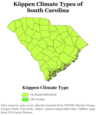
South Carolina has a humid subtropical climate, with hot summers throughout most of the state. But, an exception does occur in the Blue Ridge Mountains, as outlier pockets of an Oceanic Climate do exist. Mild winters predominate in the eastern and southern part of the state, but cool to occasionally cold winters are the standard in the northwestern area of the state, especially areas at or above 600 feet in elevation. On average, between 40 and 80 inches of precipitation falls annually across the state, potentially even in excess of 100 inches in portions of the Appalachian temperate rainforest. Tropical cyclones, and afternoon thunderstorms due to hot and humid conditions, contribute to precipitation during the summer and sometimes fall months, while extratropical cyclones contribute to precipitation during the fall, winter, and spring months. The coast experiences nearly all of their tropical weather impacts from storms coming directly from the Atlantic coast. The northwestern area of the state can receive impacts from both Atlantic basin storms moving westward from the coast and also occasionally very heavy rainfall and flooding from storms originating from the Gulf of Mexico that move inland towards the northeast after making landfall from the Florida Panhandle to Louisiana.

A humid subtropical climate is a temperate climate type characterized by hot and humid summers, and cool to mild winters. These climates normally lie on the southeast side of all continents, generally between latitudes 25° and 40° and are located poleward from adjacent tropical climates, and equatorward from either humid continental or oceanic climates. It is also known as warm temperate climate in some climate classifications.

The December 2009 North American blizzard was a powerful nor'easter that formed over the Gulf of Mexico in December 2009, and became a major snowstorm that affected the East Coast of the United States and Canadian Atlantic provinces. The snowstorm brought record-breaking December snowfall totals to Washington, D.C., Baltimore, and Philadelphia.

The North Pacific High is a semi-permanent, subtropical anticyclone located in the northeastern portion of the Pacific Ocean, located northeast of Hawaii and west of California. It is part of the great belt of anticyclones known as the subtropical ridge. It is strongest during the northern hemisphere summer and shifts towards the equator during the winter, when the Aleutian Low becomes more active. It is responsible for California's typically dry summer and fall and typically wet winter and spring, as well as Hawaii's year-round trade winds.
References
- 1 2 3 4 State Climate Office of North Carolina Extreme Weather Records Archived 2007-05-12 at the Wayback Machine Retrieved on 2008-02-24
- ↑ Florence Shatters North Carolina's Record for Most Rain Fallen from a Single Storm