
Highway 20, also known as the Chilcotin Highway, and officially dubbed the Alexander MacKenzie Highway, is one of the two main east–west routes in the Central Interior of British Columbia (the other being Highway 16. The Chilcotin Highway runs 457 km from Williams Lake westward through the Chilcotin region to North Bentinck Arm, an inlet from the Pacific Ocean where the town of Bella Coola is located. As of 2006, all but 57 km has been paved, mostly for expediting the removal of timber from the region, which, like most of British Columbia, is afflicted with pine beetle infestations. Logging traffic and ranch-related traffic on the route can be expected.
Turnagain Arm is a waterway into the northwestern part of the Gulf of Alaska. It is one of two narrow branches at the north end of Cook Inlet, the other being Knik Arm. Turnagain is subject to climate extremes and large tide ranges.

Bella Coola is a unincorporated community in the Bella Coola Valley of British Columbia, Canada. Bella Coola usually refers to the entire valley, encompassing the settlements of Bella Coola proper, Lower Bella Coola, Hagensborg, Salloompt, Nusatsum, Firvale, and Stuie. It is also the location of the head offices of the Central Coast Regional District.
Dean Channel is the upper end of one of the longest inlets of the British Columbia Coast, 105 km (65.2 mi) from its head at the mouth of the Kimsquit River. The Dean River, one of the main rivers of the Coast Mountains, enters Dean Channel about 9.5 km (5.9 mi) below the head of the inlet, at the community of Kimsquit.
The Bella Coola River is a major river on the Pacific slope of the Coast Mountains in southern British Columbia. The town of Bella Coola is at its mouth on North Bentinck Arm. Bella Coola Indian Reserve No. 1 the location of the main community today of the surviving population of the Nuxalk who gathered there after depredations by smallpox and colonialization.

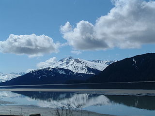
North Bentinck Arm is a short inlet about 17 km (11 mi) in length in the Central Coast region of British Columbia, Canada. It is an arm of Burke Channel and is linked via that waterway and Labouchere Channel to Dean Channel, which is one of the largest inlets of the BC Coast.

Hagensborg, originally named Kristiania, is a small community in the Bella Coola Valley in British Columbia, Canada. Its census population in 2006 was 248.
The Alexander MacKenzie Heritage Trail is a 420 km (260 mi) long historical overland route between Quesnel and Bella Coola, British Columbia, Canada Of the many grease trails connecting the Coast with the Interior, it is the most notable and often is referred to as the Grease Trail.

Tallheo is the location of a former village of the Nuxalk known as Talyu, and is a former cannery town near Bella Coola, British Columbia, Canada, on North Bentinck Arm. Tallheo is also the name of the dialect of the Nuxalk language spoken by the Talhyumc, the particular subgroup of the Nuxalk who live there.

The Nuxalk people, also referred to as the Bella Coola, Bellacoola or Bilchula, are an Indigenous First Nation of the Pacific Northwest Coast, centred in the area in and around Bella Coola, British Columbia. Their language is also called Nuxalk. Their on-reserve tribal government is the Nuxalk Nation.
The Bella Coola Valley is a relatively small but distinct region located in the Central Coast region of British Columbia, Canada, comprising the valley of the Bella Coola River and its tributaries. The region is served by BC Hwy 20, which runs from Williams Lake to the town of Bella Coola at the head of North Bentinck Arm, from where there is seasonal ferry service to Vancouver Island and Prince Rupert.
Noohalk Mountain 2099 m is a mountain in the northernmost Pacific Ranges of the Coast Mountains in British Columbia, Canada. It is located on the south side of the Bella Coola Valley between Hagensborg and Bella Coola.
The Kimsquit River is a river in the Kitimat Ranges of the Coast Mountains in British Columbia, Canada, flowing into the head of Dean Channel, one of the major inlets of the Central Coast region.
Chatscah Indian Reserve No. 2, officially Chatscah 2 is an Indian reserve of the Nuxalk Nation band government, located at the mouth of the Kimsquit River at the head of Dean Channel. Like nearby Kimsquit, at the mouth of the Dean River to the southeast, this Indian reserve was one of two reserves set aside of the once-populous Kimsquit subgroup of the Nuxalk, whose surviving post-smallpox population gathered at Bella Coola.
The Asseek River is a river in the Central Coast region of British Columbia, Canada, flowing north out of the Pacific Ranges to enter saltwater at the head of South Bentinck Arm. The name has been used since 1930, but an earlier map from 1913 shows it as the Talolail River. Also entering South Bentinck Arm a few miles north on the east side of the inlet is the Taleomey River, whose estuary forms Taleomey Narrows, a constriction of the inlet, and also where is the location of Taleomy Indian Reserve No. 3 of the Nuxalk Nation. Another constriction south of the Taleomey estuary, and immediately north of the Asseek's mouth is Bentinck Narrows, which is formed by the alluvial fan of Ickna Creek.
The Noeick River is a river in the Central Coast region of British Columbia, Canada, flowing west out of the northernmost Pacific Ranges to enter saltwater on the east side of South Bentinck Arm, immediately to the north of the mouth of the Taleomey River at Taleomey Narrows.
The Sakumtha River is a river in British Columbia, Canada, flowing south out of the Kitimat Ranges from an origin west of the Tsaydaychuz Peak massif into the Dean River north of Bella Coola.
Tallheo Hot Springs is a hot spring located on the west shore of South Bentinck Arm, an inlet on the Central Coast of British Columbia, Canada, located southwest of the community of Bella Coola. The hot springs, which are known as Ix7piixm in the Nuxalk language, are located opposite Bensins Island, the only island in South Bentinck Arm.
The Necleetsconnay River is a river in the Central Coast region of British Columbia, flowing southwest from the southernmost Kitimat Ranges to the head of North Bentinck Arm, adjacent to the mouth of the Bella Coola River and the town of Bella Coola.