Related Research Articles

Bridal Veil Falls Provincial Park is a BC Park located on the Trans-Canada Highway just east of Rosedale, British Columbia, Canada, part of the City of Chilliwack. The community of Bridal Falls is located adjacent to the falls and park as well as the interchange between the Trans-Canada and BC Highway 9 and has a variety of highway-based tourism services. Access to the falls requires a short hike from the parking lot and well groomed trails, taking most groups 15-25 minutes.
Englishman River is a river in the eastern side of Vancouver Island, British Columbia, Canada. It starts on the eastern slopes of the Beaufort Range, originating from tiny Jewel Lake and flowing in an easterly direction for 40 km (25 mi), entering the Strait of Georgia at Parksville, British Columbia. It is an important watershed providing habitat for various species of salmon and community water to the residents of Parksville and surrounding area. The Englishman River watershed includes Arrowsmith Lake, Hidden Lake, Fishtail Lake, Rowbotham Lake, Healy Lake, Shelton Lake, and Rhododendron Lake.

Fossli Provincial Park is a provincial park in British Columbia, Canada, located on Stirling Arm of Sproat Lake on Vancouver Island. The 52-hectare park, west of Port Alberni, is accessible by water or private logging road. It has few services, but has a 30-minute hiking trail to an old homestead site. The homestead belonged to Helen and Armour Ford, who donated the land for the park to the province in 1974. Saint Andrew's Creek runs through the park, and is a fall spawning ground for coho salmon.

Little Qualicum Falls Provincial Park is a provincial park in British Columbia, Canada, on central Vancouver Island, that encompasses the entire southern shore of Cameron Lake. The Island Rail Corridor line to Port Alberni passes through the park.
Okanagan Falls Provincial Park, now officially named sx̌ʷəx̌ʷnitkʷ Provincial Park, is a provincial park in British Columbia, Canada, located within the traditional territory of the Osoyoos Indian Band. Since time immemorial, the Osoyoos Indian Band's Okanagan ancestors have inhabited and cared for the lands and waters in their traditional territory. The park is also located within the town of Okanagan Falls, protecting the area around the waterfall of the same name, which lies below the outlet of Skaha Lake in the course of the Okanagan River.
Pyramid Creek Falls Provincial Park is a provincial park in British Columbia, Canada, located on the east side of the North Thompson River between the towns of Blue River (S) and Valemount (N).

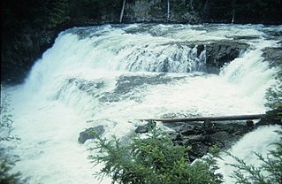
Rearguard Falls Provincial Park is a provincial park in British Columbia, Canada, protecting Rearguard Falls on the Fraser River. It is located just above its emergence into the Rocky Mountain Trench near the community of Tete Jaune Cache. The park is easily accessed via BC Highway 16. Rearguard Falls is one of only two waterfalls on the 1,375 km (854 mi)-long Fraser River; the other is a few kilometres upstream at Overlander Falls. Rearguard Falls offers a view of the return of Chinook salmon for spawning.

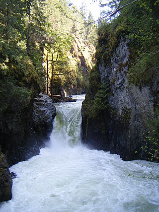
Stamp River Provincial Park is a provincial park in British Columbia, Canada. The 327-hectare park is located 14 km north of Port Alberni on Vancouver Island. There are 23 camping spaces and 2 km of trails within the park along the Stamp River, named for Edward Stamp, a sawmill pioneer in the Alberni Valley.

The Kuang Si Falls or Kuang Xi Falls, alternatively known as the Tat Kuang Si Waterfalls, is a three-tiered waterfall about 29 kilometers (18 mi) south of Luang Prabang. The waterfalls are a favorite side trip for tourists in Luang Prabang, and begin in shallow pools atop a steep hillside. These lead to the main fall with a drop of 60 meters (200 ft).
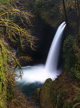
Metlako Falls is a waterfall on Eagle Creek in the Columbia River Gorge National Scenic Area in Hood River County, Oregon, United States. It is the furthest downstream of the major waterfalls on Eagle Creek. Like upstream Punch Bowl Falls, Metlako is also in the form of a punchbowl. The falls is 31 meters (101 ft) tall, though people have measured it anywhere from 30 to 46 m tall. It is the upstream limit for salmon spawning in Eagle Creek.
Basalt Falls is a waterfall on the Dean River in the Chilcotin District of the Central Interior of British Columbia, located north of the community of Anahim Lake. It is approximately 12 feet (3.7 m) in height and is composed of columnar basalt of the Chilcotin Group.
McDougall Falls is a waterfall on the Murtle River in Wells Gray Provincial Park, east-central British Columbia, Canada.

Meadow Falls is one of seven waterfalls on the Murtle River west of Murtle Lake in Wells Gray Provincial Park, east-central British Columbia, Canada. Meadow Falls is 8 m (26 ft) high.

Horseshoe Falls is one of seven waterfalls on the Murtle River west of Murtle Lake in Wells Gray Provincial Park, east-central British Columbia, Canada. Horseshoe Falls has two steps, 100 m (328 ft) apart; the upper drop is 6 m (20 ft) high and the lower and much wider drop is 10 m (33 ft) high.
The Clowhom River is a short, 19.8-kilometre (12.3 mi) river in British Columbia. It flows into the head of the Salmon Inlet about 26.2 km west of Squamish.

The Cenarth Falls is a cascade of waterfalls just upstream of the road bridge in the village of Cenarth in Ceredigion, bordering Carmarthenshire and Pembrokeshire, Wales.
Cascadero Falls is a waterfall on the Finlay River in the Northern Interior of British Columbia, Canada, located just below that river's head at the outlet of Thutade Lake. The height of the falls is 180 ft and below it there are numerous cascades or rapids in a twisting course prior to the river's general northeastward trend from this area. The falls are slated for hydroelectric development in connection with the area's mines, the largest of which is the Kemess Mine owned by Northgate Minerals Inc., located just east of the foot of Thutade Lake in the valley of Kemess Creek.
The Seymour River is a river in the North Shuswap of British Columbia, Canada. It starts from the Monashee Mountains north of Shuswap Lake, and flows towards south into the northern end of the Seymour Arm of the lake.
The Takia River is a tributary of the Dean River in British Columbia, Canada, flowing northwest to meet the Dean to the south of Sigutlat Lake. Salmon House Falls is located at the confluence of the two rivers, which is to the northwest of Tsitsutl Peak.

Cascade Falls Regional Park is a regional park under the administration of the Fraser Valley Regional District in the Hatzic Valley of the Lower Mainland region of British Columbia, Canada. The park was originally 9.5 hectares in area but was expanded to a current 22 hectares. It has picnic tables and pit toilets, with various hiking trails and a walkway leading to a viewing platform over a large waterfall, which is 15 minutes walk from the park's parking lot.
References
52°44′57″N126°20′19″W / 52.74917°N 126.33861°W
| | This article about a location in the Cariboo Regional District, Canada is a stub. You can help Wikipedia by expanding it. |