The list of Quebec Water Channels aims to regroup all the artificial watercourses of Quebec and all the water channels constituting the seaway of the St. Lawrence River, in its Quebec part.
The list of Quebec Water Channels aims to regroup all the artificial watercourses of Quebec and all the water channels constituting the seaway of the St. Lawrence River, in its Quebec part.

The St. Lawrence Seaway is a system of locks, canals, and channels in Canada and the United States that permits oceangoing vessels to travel from the Atlantic Ocean to the Great Lakes of North America, as far inland as Duluth, Minnesota, at the western end of Lake Superior. The seaway is named for the St. Lawrence River, which flows from Lake Ontario to the Atlantic Ocean. Legally, the seaway extends from Montreal, Quebec, to Lake Erie, and includes the Welland Canal. Ships from the Atlantic Ocean are able to reach ports in all five of the Great Lakes.

The St. Lawrence River is a large river in the middle latitudes of North America, flowing from Lake Ontario in a roughly northeasterly direction into the Gulf of St. Lawrence, connecting the Great Lakes to the North Atlantic Ocean and forming the primary drainage outflow of the Great Lakes Basin. The river traverses the Canadian provinces of Ontario and Quebec as well as the U.S. state of New York, and is part of the international boundary between Canada and the United States. It also provides the basis for the commercial St. Lawrence Seaway.

The Gulf of St. Lawrence is the outlet of the North American Great Lakes via the St. Lawrence River into the Atlantic Ocean. The gulf is a semi-enclosed sea, covering an area of about 226,000 square kilometres (87,000 sq mi) and containing about 34,500 cubic kilometres (8,300 cu mi) of water, at an average depth of 152 metres (500 ft).

The Great Lakes Waterway (GLW) is a system of natural channels and artificial canals which enable navigation between the North American Great Lakes. Though all of the lakes are naturally connected as a chain, water travel between the lakes was impeded for centuries by obstacles such as Niagara Falls and the rapids of the St. Marys River.

A waterway is any navigable body of water. Broad distinctions are useful to avoid ambiguity, and disambiguation will be of varying importance depending on the nuance of the equivalent word in other languages. A first distinction is necessary between maritime shipping routes and waterways used by inland water craft. Maritime shipping routes cross oceans and seas, and some lakes, where navigability is assumed, and no engineering is required, except to provide the draft for deep-sea shipping to approach seaports (channels), or to provide a short cut across an isthmus; this is the function of ship canals. Dredged channels in the sea are not usually described as waterways. There is an exception to this initial distinction, essentially for legal purposes, see under international waters.

Lake Saint Pierre is a lake in Quebec, Canada, a widening of the Saint Lawrence River between Sorel-Tracy and Trois-Rivières. It is located downstream, and northeast, of Montreal; and upstream, and southwest, of Quebec City. The end of the lake delimits the beginning of the estuary of Saint Lawrence.

The Richelieu River is a river of Quebec, Canada, and a major right tributary of the St. Lawrence River. It rises at Lake Champlain, from which it flows northward through Quebec and empties into the St. Lawrence. It was formerly known by the French as the Iroquois River and the Chambly River, and was named for Cardinal Richelieu, the powerful minister under Louis XIII.

The Welland Canal is a ship canal in Ontario, Canada, connecting Lake Ontario and Lake Erie. It forms a key section of the St. Lawrence Seaway and Great Lakes Waterway. Traversing the Niagara Peninsula from Port Weller in St. Catharines to Port Colborne, it enables ships to ascend and descend the Niagara Escarpment and bypass Niagara Falls. It is the fourth canal connecting these waterways; three smaller predecessors also bore the same name.

The Beauharnois Canal is located in southwestern Quebec, Canada. The canal is part of the Saint Lawrence Seaway.
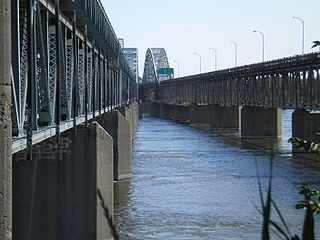
The Honoré Mercier Bridge in Quebec, Canada, connects the Montreal borough of LaSalle on the Island of Montreal with the Mohawk reserve of Kahnawake, Quebec and the suburb of Châteauguay on the south shore of the Saint Lawrence River. It is the most direct southerly route from the island of Montreal toward the US border. It carries Route 138, originally Route 4. It is 1.361 km (0.846 mi) in length and contains four steel trusses on its first section. The height of the bridge varies from 12.44 m (40.8 ft) to 33.38 m (109.5 ft) with the highest sections located over the St. Lawrence Seaway. The bridge is named after former premier of Quebec Honoré Mercier.

The Welland By-pass, completed in 1973, was a massive construction project on the Welland Canal in Ontario, Canada.

The Great Lakes Basin consists of the Great Lakes and the surrounding lands of the states of Illinois, Indiana, Michigan, Minnesota, New York, Ohio, Pennsylvania, and Wisconsin in the United States, and the province of Ontario in Canada, whose direct surface runoff and watersheds form a large drainage basin that feeds into the lakes. It is generally considered to also include a small area around and beyond Wolfe Island, Ontario, at the east end of Lake Ontario, which does not directly drain into the Great Lakes, but into the Saint Lawrence River.
The Great Lakes Megalopolis consists of the group of metropolitan areas in North America largely in the Great Lakes region and along the Saint Lawrence River. It extends from the Midwestern United States in the south and west to western Pennsylvania and Western New York in the east and northward through Southern Ontario into southwestern Quebec in Canada. It is the most populated and largest megalopolis in North America.

The Beauharnois generating station is a run-of-the-river hydroelectric power station along the Saint Lawrence Seaway on the Saint Lawrence River, in Quebec, Canada. The station was built in three phases, and comprises 36 turbines, capable of generating up to 1,903 MW of electrical power. Constructions on the facility began in 1930 and was completed in 1961.

The Lake Champlain Seaway was a canal project proposed in the late 19th century and considered as late as the 1960s to connect New York State's Hudson River and Quebec's St. Lawrence River with a deep-water canal. The objective was to allow easy ship traffic from New York City to Montreal through Lake Champlain, lowering transportation costs between the two cities.
The Canada Marine Act was passed in 1998 under the stewardship of David Collenette, who was Canada's Minister of Transport at that time. It was intended to modernize Canada's most important ports and make "the system of Canadian ports competitive, efficient and commercially oriented, providing for the establishing of port authorities and the divesting of certain harbours and ports, for the commercialization of the St. Lawrence Seaway and ferry services and other matters related to maritime trade and transport and amending the Pilotage Act and amending and repealing other Acts as a consequence."
The Beauharnois-Salaberry Regional Park is a regional park located in the Beauharnois-Salaberry Regional County Municipality, in administrative region of Montérégie, in Quebec, in Canada.