This is a list of Sites of Community Importance in Valencian Community .
| ID | Name | Coordinates | Image |
|---|---|---|---|
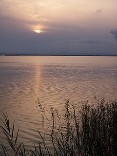
| ES0000023 | Albufera (official name: L'Albufera) Other names: n/a | 39°18′19″N0°18′47″W / 39.3053°N 0.3131°W | 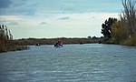 |
| ES0000058 | Natural Park of El Fondo (official name: el Fondo d'Elx-Crevillent) Other names: n/a | 38°11′14″N0°44′58″W / 38.1872°N 0.7494°W | 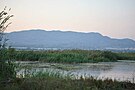 |
| ES0000059 | Llacunes de la Mata i Torrevieja (official name: Llacunes de la Mata i Torrevieja) Other names: n/a | 38°00′37″N0°42′09″W / 38.0103°N 0.7025°W |  |
| ES0000060 | Prat de Cabanes i Torreblanca (official name: Prat de Cabanes i Torreblanca) Other names: n/a | 40°10′11″N0°10′57″E / 40.1697°N 0.1825°E |  |
| ES0000061 | Columbretes Islands (official name: Árees emergides de les Illes Columbretes) Other names: n/a | 39°53′42″N0°41′01″E / 39.895°N 0.6837°E | |
| ES0000120 | Salinas de Santa Pola (official name: Salinas de Santa Pola) Other names: n/a | 38°11′03″N0°37′14″W / 38.1842°N 0.6206°W |  |
| ES0000147 | Marjal de Pego-Oliva (official name: Marjal de Pego-Oliva) Other names: n/a | 38°52′25″N0°03′43″W / 38.8736°N 0.0619°W |  |
| ES0000148 | Marjal dels Moros (official name: Marjal dels Moros) Other names: n/a | 39°37′33″N0°15′22″W / 39.6258°N 0.2561°W |  |
| ES0000211 | Desembocadura del riu Millars (official name: Desembocadura del riu Millars) Other names: n/a | 39°55′47″N0°03′08″W / 39.9297°N 0.0522°W |  |
| ES0000213 | Serres de Mariola i el Carrascar de la Font Roja (official name: Serres de Mariola i el Carrascar de la Font Roja) Other names: n/a | 38°42′35″N0°32′56″W / 38.7097°N 0.5489°W |  |
| ES0000462 | Clot de Galvany (official name: Clot de Galvany) Other names: n/a | 38°14′42″N0°32′02″W / 38.2451°N 0.534°W |  |
| ES5211007 | Montgó Massif (official name: Montgó) Other names: n/a | 38°48′42″N0°07′59″E / 38.811667°N 0.133056°E |  |
| ES5211009 | Natural Park of Penyal d'Ifac (official name: Penyal d'Ifac) Other names: n/a | 38°38′05″N0°04′35″E / 38.6348°N 0.0764°E | 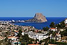 |
| ES5212004 | Riu Gorgos (official name: Riu Gorgos) Other names: n/a | 38°45′21″N0°03′44″W / 38.755833°N 0.062222°W |  |
| ES5212006 | Laguna de Salinas (official name: Laguna de Salinas) Other names: n/a | 38°30′18″N0°53′26″W / 38.505°N 0.8905559999999999°W |  |
| ES5212007 | Salero y Cabecicos de Villena (official name: Salero y Cabecicos de Villena) Other names: n/a | 38°38′09″N0°54′56″W / 38.635833°N 0.915556°W |  |
| ES5212008 | Maigmó i Serres de la Foia de Castalla (official name: Maigmó i Serres de la Foia de Castalla) Other names: n/a | 38°33′24″N0°43′16″W / 38.556667°N 0.721111°W |  |
| ES5212009 | Algepsars de Finestrat (official name: Algepsars de Finestrat) Other names: n/a | 38°34′06″N0°13′32″W / 38.5683°N 0.2256°W |  |
| ES5212010 | Arenal de Petrer (official name: Arenal de Petrer) Other names: n/a | 38°30′43″N0°46′42″W / 38.511944°N 0.7783329999999999°W | |
| ES5212011 | Rambla de las Estacas (official name: Rambla de las Estacas) Other names: n/a | 37°55′51″N0°43′34″W / 37.930833°N 0.726111°W | |
| ES5212012 | Sierra de Escalona y Dehesa de Campoamor (official name: Sierra de Escalona y Dehesa de Campoamor) Other names: n/a | 37°56′07″N0°49′57″W / 37.935278°N 0.8325°W | 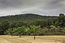 |
| ES5213018 | Penya-segats de la Marina (official name: Penya-segats de la Marina) Other names: n/a | 38°43′51″N0°10′56″E / 38.7308°N 0.1822°E | 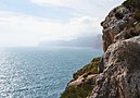 |
| ES5213019 | Aitana, Serrella i Puigcampana (official name: Aitana, Serrella i Puigcampana) Other names: n/a | 38°39′10″N0°13′10″W / 38.65277800000001°N 0.219444°W |  |
| ES5213020 | Serres del Ferrer i Bèrnia (official name: Serres del Ferrer i Bèrnia) Other names: n/a | 38°40′41″N0°03′25″W / 38.6781°N 0.0569°W |  |
| ES5213021 | Serra Gelada i Litoral de la Marina Baixa (official name: Serra Gelada i Litoral de la Marina Baixa) Other names: n/a | 38°32′06″N0°05′24″W / 38.535°N 0.09°W | 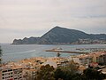 |
| ES5213022 | Serra de Crevillent (official name: Serra de Crevillent) Other names: n/a | 38°15′57″N0°52′45″W / 38.265833°N 0.879167°W |  |
| ES5213023 | Sierra de Callosa de Segura (official name: Sierra de Callosa de Segura) Other names: n/a | 38°07′40″N0°54′14″W / 38.1278°N 0.9039°W | 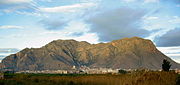 |
| ES5213024 | Tabarca (official name: Illa de Tabarca) Other names: n/a | 38°09′53″N0°28′29″W / 38.1648°N 0.4747°W |  |
| ES5213025 | Dunes de Guardamar (official name: Dunes de Guardamar) Other names: n/a | 38°05′52″N0°38′52″W / 38.09777800000001°N 0.647778°W |  |
| ES5213026 | Sierra de Orihuela (official name: Sierra de Orihuela) Other names: n/a | 38°05′50″N0°58′51″W / 38.097222°N 0.980833°W | 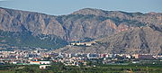 |
| ES5213032 | Cap de les Hortes (official name: Cap de les Hortes) Other names: n/a | 38°21′12″N0°25′14″W / 38.3534°N 0.4206°W |  |
| ES5213033 | Litoral de Cabo Roig (official name: Litoral de Cabo Roig) Other names: n/a | 37°54′37″N0°44′09″W / 37.9104°N 0.7359°W |  |
| ES5213039 | Sierra de Salinas (official name: Sierra de Salinas) Other names: n/a | 38°30′51″N0°57′32″W / 38.514167°N 0.958889°W | 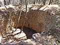 |
| ES5213042 | Valls de la Marina (official name: Valls de la Marina) Other names: n/a | 38°48′02″N0°11′19″W / 38.800556°N 0.188611°W |  |
| ES5213054 | Alhorines Valley (official name: Els Alforins) Other names: n/a | 38°47′50″N0°48′00″E / 38.797222°N 0.8°E |  |
| ES5214001 | Cueva del Perro-Cox (official name: Cueva del Perro-Cox) Other names: n/a | 38°08′19″N0°53′55″W / 38.1387°N 0.8986°W | |
| ES5214002 | Tunel de Canals (official name: Tunel de Canals) Other names: n/a | 38°55′42″N0°34′37″W / 38.9283°N 0.5770000000000001°W | |
| ES5214003 | Cova dels Mosseguellos-Vallada (official name: Cova dels Mosseguellos-Vallada) Other names: n/a | 38°54′14″N0°44′14″W / 38.9039°N 0.7372°W | |
| ES5214004 | Cova Juliana (official name: Cova Juliana) Other names: n/a | 38°40′39″N0°27′52″W / 38.6774°N 0.4644°W | |
| ES5221002 | Desert de les Palmes Natural Park (official name: Desert de les Palmes) Other names: n/a | 40°04′33″N0°02′35″E / 40.0758°N 0.0431°E | 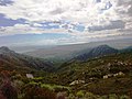 |
| ES5222001 | Serra d'Espadà (official name: Serra d'Espadà) Other names: n/a | 39°55′47″N0°23′05″W / 39.9297°N 0.3847°W |  |
| ES5222002 | Marjal de Peníscola (official name: Marjal de Peníscola) Other names: n/a | 40°22′17″N0°24′08″E / 40.3714°N 0.4022°E |  |
| ES5222004 | Curs alt del riu Millars (official name: Curs alt del riu Millars) Other names: n/a | 40°03′59″N0°35′12″W / 40.066389°N 0.586667°W |  |
| ES5222005 | Marjal de Nules (official name: Marjal de Nules) Other names: n/a | 39°50′09″N0°06′32″W / 39.8358°N 0.1089°W |  |
| ES5222006 | Platja de Moncofa (official name: Platja de Moncofa) Other names: n/a | 39°46′38″N0°08′52″W / 39.777222°N 0.147778°W | |
| ES5223002 | Alt Maestrat (official name: L'Alt Maestrat) Other names: n/a | 40°25′19″N0°09′54″W / 40.4219°N 0.165°W | |
| ES5223004 | Penyagolosa (official name: Penyagolosa) Other names: n/a | 40°14′23″N0°23′24″W / 40.2397°N 0.39°W |  |
| ES5223005 | Alto Palancia (official name: Alt Palància) Other names: n/a | 39°55′51″N0°43′15″W / 39.9308°N 0.7208°W | 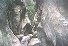 |
| ES5223007 | Marjal d'Almenara (official name: Marjal d'Almenara) Other names: n/a | 39°44′20″N0°11′48″W / 39.738889°N 0.196667°W | 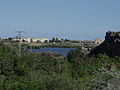 |
| ES5223029 | Bergantes (river) (official name: Riu Bergantes) Other names: n/a | 40°42′11″N0°10′33″W / 40.703056°N 0.175833°W |  |
| ES5223036 | Serra d'Irta (official name: Serra d'Irta) Other names: n/a | 40°19′31″N0°19′21″E / 40.325278°N 0.3225°E |  |
| ES5223037 | Litoral de Benicàssim (official name: Litoral de Benicàssim) Other names: n/a | 40°03′26″N0°06′12″E / 40.0573°N 0.1032°E |  |
| ES5223053 | Forat d'en Ferràs-Orpesa (official name: Forat d'en Ferràs-Orpesa) Other names: n/a | 40°05′15″N0°06′15″E / 40.0876°N 0.1041°E | |
| ES5223055 | La Serra d'en Galceran (official name: Serra d'en Galceràn) Other names: n/a | 40°18′07″N0°00′00″E / 40.3019°N 0.0001°E |  |
| ES5224001 | Cova Obscura-Atzeneta del Maestrat (official name: Cova Obscura-Atzeneta del Maestrat) Other names: n/a | 40°11′59″N0°12′55″W / 40.1997°N 0.2152°W | |
| ES5232002 | Serra Calderona (official name: Serra Calderona) Other names: n/a | 39°44′14″N0°26′28″W / 39.7372°N 0.4411°W |  |
| ES5232003 | Curs mitjà del riu Palància (official name: Curs mitjà del riu Palància) Other names: n/a | 39°51′11″N0°28′18″W / 39.853056°N 0.471667°W |  |
| ES5232004 | Rius del Racó d'Ademús (official name: Rius del Racó d'Ademús) Other names: n/a | 40°04′32″N1°16′01″W / 40.075556°N 1.266944°W | |
| ES5232005 | Lavajos de Sinarcas (official name: Lavajos de Sinarcas) Other names: n/a | 39°45′23″N1°14′23″W / 39.7564°N 1.2398°W | |
| ES5232006 | Alto Túria (official name: Alto Túria) Other names: n/a | 39°48′28″N1°08′42″W / 39.8078°N 1.145°W |  |
| ES5232007 | Júcar (official name: Riu Xúquer) Other names: n/a | 39°07′04″N0°38′34″W / 39.117778°N 0.642778°W |  |
| ES5232008 | Curs mitjà del riu Albaida (official name: Curs mitjà del riu Albaida) Other names: n/a | 38°55′44″N0°27′59″W / 38.928889°N 0.4663890000000001°W |  |
| ES5232009 | Serra del Castell de Xàtiva (official name: Serra del Castell de Xàtiva) Other names: n/a | 38°59′07″N0°31′09″W / 38.9853°N 0.5192°W |  |
| ES5232010 | Cap de Cullera (official name: Cap de Cullera) Other names: n/a | 39°11′17″N0°12′59″W / 39.188056°N 0.216389°W | 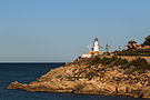 |
| ES5233001 | Tinença de Benifassà, Turmell i Vallivana (official name: Tinença de Benifassà, Turmell i Vallivana) Other names: n/a | 40°37′19″N0°06′18″E / 40.6219°N 0.105°E | 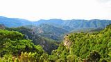 |
| ES5233006 | Puebla de San Miguel (official name: Puebla de San Miguel) Other names: n/a | 40°03′32″N1°09′54″W / 40.058889°N 1.165°W |  |
| ES5233008 | Sabinar de Alpuente (official name: Sabinar de Alpuente) Other names: n/a | 39°56′05″N0°56′14″W / 39.9347°N 0.9372°W | |
| ES5233009 | Sierra de Utiel (official name: Sierra del Negrete) Other names: n/a | 39°35′50″N1°01′39″W / 39.5972°N 1.0275°W |  |
| ES5233010 | Hoces del Cabriel (official name: Hoces del Cabriel) Other names: n/a | 39°25′02″N1°28′02″W / 39.4172°N 1.4672°W |  |
| ES5233011 | Sierras de Martés y el Ave (official name: Sierras de Martés y el Ave) Other names: n/a | 39°18′09″N0°51′19″W / 39.3025°N 0.8553°W |  |
| ES5233012 | Valle de Ayora y Sierra del Boquerón (official name: Valle de Ayora y Sierra del Boquerón) Other names: n/a | 39°11′03″N1°07′20″W / 39.1842°N 1.1222°W |  |
| ES5233013 | Serra de Corbera (official name: Serra de Corbera) Other names: n/a | 39°06′41″N0°19′35″W / 39.111389°N 0.326389°W | |
| ES5233015 | Serres del Montdúver i Marxuquera (official name: Serres del Montdúver i Marxuquera) Other names: n/a | 39°00′05″N0°18′23″W / 39.001389°N 0.306389°W |  |
| ES5233030 | Marjal de la Safor (official name: Marjal de la Safor) Other names: n/a | 39°02′01″N0°11′54″W / 39.0336°N 0.1983°W |  |
| ES5233034 | Sierra del Mugrón (official name: Sierra del Mugrón) Other names: n/a | 38°56′54″N1°07′39″W / 38.948333°N 1.1275°W |  |
| ES5233035 | Arroyo Cerezo (official name: Arroyo Cerezo) Other names: n/a | 40°04′33″N1°22′52″W / 40.075833°N 1.381111°W | |
| ES5233038 | Dunes de la Safor (official name: Dunes de la Safor) Other names: n/a | 38°58′14″N0°08′12″W / 38.970556°N 0.136667°W |  |
| ES5233040 | Muela de Cortes y el Caroche (official name: Muela de Cortes y el Caroche) Other names: n/a | 39°03′50″N0°52′41″W / 39.0639°N 0.8781°W |  |
| ES5233041 | Serra de la Safor (official name: Serra de la Safor) Other names: n/a | 38°52′13″N0°16′18″W / 38.870278000000006°N 0.271667°W |  |
| ES5233044 | Sierra de Malacara (official name: Sierra de Malacara) Other names: n/a | 39°24′51″N0°57′12″W / 39.4142°N 0.9533°W |  |
| ES5233045 | Sierra de Enguera (official name: Serra d'Enguera) Other names: n/a | 38°53′52″N0°50′14″W / 38.8978°N 0.8372°W |  |
| ES5233047 | Ullals del riu Verd (official name: Ullals del riu Verd) Other names: n/a | 39°08′49″N0°31′55″W / 39.146944°N 0.531944°W | |
| ES5233048 | Sima de les Graelles-Tous (official name: Sima de les Graelles-Tous) Other names: n/a | 39°06′50″N0°40′01″W / 39.1138°N 0.667°W | |
| ES5233049 | Cova de les Rates Penades (Ròtova) (official name: Cova de les Rates Penades (Ròtova)) Other names: n/a | 38°55′58″N0°16′28″W / 38.9327°N 0.2744°W | |
| ES5233050 | Cova de la Moneda-Cotes (official name: Cova de la Moneda-Cotes) Other names: n/a | 39°03′27″N0°36′46″W / 39.0575°N 0.6128°W | |
| ES5233051 | Cova de les Meravelles de Llombai (official name: Cova de les Meravelles de Llombai) Other names: n/a | 39°18′47″N0°35′06″W / 39.3131°N 0.5851°W | |
| ES5234001 | Cova del Sardiner-Sagunt (official name: Cova del Sardiner-Sagunt) Other names: n/a | 39°42′37″N0°16′24″W / 39.7102°N 0.2732°W | |
| ES5234002 | Cueva Negra-Ayora (official name: Cueva Negra-Ayora) Other names: n/a | 39°04′26″N1°12′32″W / 39.074°N 1.2089°W | |
| ES5234003 | Tunel del Carcalín-Buñol (official name: Tunel del Carcalín-Buñol) Other names: n/a | 39°24′56″N0°48′24″W / 39.4156°N 0.8066°W | |
| ES5234004 | Cueva del Barranco Hondo-Cheste (official name: Cueva del Barranco Hondo-Cheste) Other names: n/a | 39°31′25″N0°43′28″W / 39.5237°N 0.7244°W | |
| ES5234005 | Sima de l'Àguila-Picassent (official name: Sima de l'Àguila-Picassent) Other names: n/a | 39°19′41″N0°31′24″W / 39.328°N 0.5232°W | |
| ES5234006 | Cova de les Meravelles d'Alzira (official name: Cova de les Meravelles d'Alzira) Other names: n/a | 39°07′29″N0°25′29″W / 39.1248°N 0.4248°W | |
| ES5234007 | Cova Xurra-Gandia (official name: Cova Xurra-Gandia) Other names: n/a | 38°58′27″N0°12′54″W / 38.9742°N 0.2149°W | |