Sierra de Utiel | |
---|---|
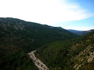
The Benagéber reservoir, in the Utiel Range area | |
Highest point | |
Elevation | 1,306 m (4,285 ft) |
Listing | Mountains of the Valencian Community |
Coordinates | 39°37′16″N0°58′48″W / 39.62111°N 0.98000°W Coordinates: 39°37′16″N0°58′48″W / 39.62111°N 0.98000°W |
Geography | |
Location | Plana d'Utiel and Serrans, Valencian Community |
Parent range | Iberian System, Southeastern end |
Geology | |
Mountain type | Karstic (Jurassic) |
Climbing | |
Easiest route | Drive from Utiel, Sinarcas, Loriguilla, Domeño, Chera, Benagéber or Calles |
Sierra de Utiel [1] (Valencian : Serra d'Utiel) is a 16.45 km (10 mi) long mountain range in the Alt Palància, Alt Millars and Plana Baixa comarcas, Valencian Community, Spain. Its highest point is the 1,306 m high El Remedio (Valencian : El Remei). There is often snow in the winter. [2]
Plana Baixa is a comarca in the province of Castellón, Valencian Community, Spain.
The Valencian Community is an autonomous community of Spain. It is the fourth most populous autonomous community after Andalusia, Catalonia and Madrid with more than 4.9 million inhabitants. Its homonymous capital Valencia is the third largest city and metropolitan area in Spain. It is located along the Mediterranean coast on the east side of the Iberian peninsula. It borders with Catalonia to the north, Aragon and Castilla–La Mancha to the west, and Murcia to the south. The Valencian Community consists of three provinces which are Castellón, Valencia and Alicante.
Spain, officially the Kingdom of Spain, is a country mostly located on the Iberian Peninsula in Europe. Its territory also includes two archipelagoes: the Canary Islands off the coast of Africa, and the Balearic Islands in the Mediterranean Sea. The African enclaves of Ceuta and Melilla make Spain the only European country to have a physical border with an African country (Morocco). Several small islands in the Alboran Sea are also part of Spanish territory. The country's mainland is bordered to the south and east by the Mediterranean Sea except for a small land boundary with Gibraltar; to the north and northeast by France, Andorra, and the Bay of Biscay; and to the west and northwest by Portugal and the Atlantic Ocean.
There are four ranges running parallel to each other:
A depression in geology is a landform sunken or depressed below the surrounding area. Depressions form by various mechanisms.
Chera is a municipality in the comarca of Requena-Utiel in the Valencian Community, Spain. The name in Valencian is Xera, but the local language is Spanish, not Valencian.
The Utiel Range has been declared a Site of Community Importance (SCI). [4]
A Site of Community Importance (SCI) is defined in the European Commission Habitats Directive (92/43/EEC) as a site which, in the biogeographical region or regions to which it belongs, contributes significantly to the maintenance or restoration at a favourable conservation status of a natural habitat type or of a species and may also contribute significantly to the coherence of Natura 2000, and/or contributes significantly to the maintenance of biological diversity within the biogeographic region or regions concerned.
In Spain traditionally and historically, some autonomous communities are also divided into comarcas.
Baix Maestrat is a coastal comarca located in the north of the province of Castellón, Valencian Community, Spain. The capital of the comarca is Vinaròs.
Utiel is a municipality in the comarca of Requena-Utiel in the Valencian Community, Spain.
Manchuela or La Manchuela is a comarca located in Castile-La Mancha and Valencian Community, Spain.
Desert de les Palmes, also known as Serra del Desert de les Palmes is an 18.8 km long mountain range in the Plana Alta comarca, Valencian Community, Spain. Its highest point is Bartolo.
Talaies d'Alcalà, also known as Serra de les Talaies or simply Les Talaies, is a 21.5 km long mountain range in the Baix Maestrat comarca, Valencian Community, Spain. Its highest point is Talaia Grossa.
Penyagolosa is a mountain in the Alcalatén area, Valencian Community, Spain. Geologically it is part of the Iberian System, located at the eastern end of Iberian Peninsula. Its peak is at 1,813 meters above sea level and is often crowned with snow in the winter.
Serra de Sant Pere or Serra del Solà is a 5.8 km (4 mi) long mountain range in the Baix Maestrat comarca, Valencian Community, Spain. Its highest point is Tossal de Sant Pere. The slopes are covered in low Mediterranean vegetation
Sierra del Toro is a 21 km (13 mi) long mountain range in the Alt Palància comarca, Valencian Community, close to the limit with Teruel Province, Aragon, Spain. It is named after the nearby town of El Toro.
Sierra de Javalambre is a 29 km (18 mi) long mountain range in the Gúdar-Javalambre comarca of Aragon and the Rincón de Ademuz and Serrans comarcas of the Valencian Community, Spain.
Serra d'Espadà is a 51 km (32 mi) long mountain range in the Alt Palància, Alt Millars and Plana Baixa comarcas, in the Province of Castellón, Valencian Community, Spain. Its highest point is La Ràpita.
Serra Calderona, often referred to as La Calderona is a 49 km (30 mi) long mountain range in the Camp de Túria, Horta Nord and Alt Palància comarcas of the Valencian Community, between the provinces of Castelló and Valencia Spain.
Serra de Vallivana or Muntanyes de Vallivana is an over 14 km (9 mi) long mountain range straddling the Alt Maestrat and Baix Maestrat comarcas, Valencian Community, Spain.
Serra de l'Espadella is an over 4 km (2 mi) long mountain range in the Baix Maestrat comarca, Valencian Community, Spain. Its highest point is Espadella. These mountains are frequently covered in snow in the winter.
Serra de d'Esparreguera or Serra Esparreguera is an over 17 km (11 mi) long mountain range in the Alt Maestrat comarca, Valencian Community, Spain.
La Serra d'en Galceran is a small municipality in the province of Castelló, Valencian Community, Spain. It is located inland surrounded by the mountain range known as Serra d'en Galceran. The town gives its name to the range.
Serra de la Valldàngel or Serra de la Vall d'Àngel,, is a mountain range in the Baix Maestrat comarca, Castellón Province, Valencian Community, Spain.
Serra del Turmell, also known as Serra del Mont Turmell, is an over 12 km (7 mi) long mountain range in the Baix Maestrat comarca, Valencian Community, Spain.
Valencia or València is a province of Spain, in the central part of the Valencian Community. Of the province's 2,547,986 people (2018), one-third live in the capital, Valencia, which is also the capital of the autonomous community. There are 265 municipalities in the province.
The Font Roja Natural Park is a natural park situated in Alcoy, in the autonomous community of Valencia, Spain.