
Kern County is a county located in the U.S. state of California. As of the 2020 census, the population was 909,235. Its county seat is Bakersfield.
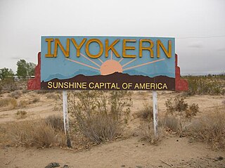
Inyokern is a census-designated place (CDP) in Kern County, California, United States. Its name derives from its location near the border between Inyo and Kern Counties. Inyokern is located 8 miles (13 km) west of Ridgecrest, at an elevation of 2,434 feet (742 m). It is on the western side of the Indian Wells Valley. The population was 988 in the 2020 census, down from 1,099 in the 2010 census. It was a railroad town established along the Southern Pacific railroad's Lone Pine Branch and with WWII became site of the Naval Air Weapons Station China Lake.

The Antelope Valley is located in northern Los Angeles County, California, United States, and the southeast portion of California's Kern County, and constitutes the western tip of the Mojave Desert. It is situated between the Tehachapi, Sierra Pelona, and the San Gabriel Mountains. The valley was named for the pronghorns that roamed there until they were all eliminated in the 1880s, mostly by hunting, or resettled in other areas. The principal cities in the Antelope Valley are Palmdale and Lancaster.

Golden West Airlines was a commuter airline that operated flights on a high volume schedule in California. It ceased operations in 1983.
Naval Air Weapons Station (NAWS) China Lake is a large military installation in California that supports the research, testing and evaluation programs of the United States Navy. It is part of Navy Region Southwest under Commander, Navy Installations Command, and was originally known as Naval Ordnance Test Station (NOTS).

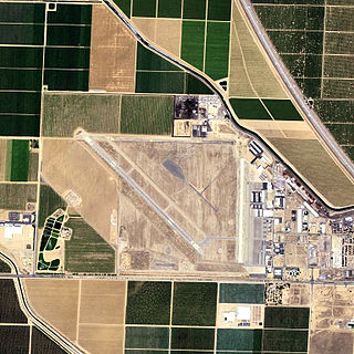
Inyokern Airport is a public use airport located 1 nautical mile northwest of the central business district of Inyokern, in Kern County, California, United States. It is owned by the Indian Wells Valley Airport District and serves the Indian Wells Valley area. The airport is mostly used for general aviation and was previously served by a number of commuter and regional airlines over the years with passenger flights to Los Angeles (LAX).

General William J. Fox Airfield is a county-owned, public airport in Los Angeles County, California, five miles northwest of Lancaster, California, United States. Locally known as Fox Field, the airport serves the Antelope Valley. The airport is named after Brigadier General William J. Fox, "a Marine war hero, a movie stunt man, the first Los Angeles County engineer and, for 20 years after his retirement, a cowboy."

Area code 661 is a telephone area code in the North American Numbering Plan for the southern part of the San Joaquin Valley and for the far northern part of the Los Angeles metropolitan area. The numbering plan area comprises most of Kern County, most of northern Los Angeles County, and small parts of Ventura County, Santa Barbara County, and Tulare County. It was created in an area code split of area code 805 on February 13, 1999.
Bakersfield Airport can refer to multiple airports in or near Bakersfield, California:

Eastern Sierra Regional Airport is two miles east of Bishop, in Inyo County, California, United States. It is owned by the City of Los Angeles, Department of Public Works and operated by Inyo County.

Delano Municipal Airport is six miles southwest of Delano, in Kern County, California, United States.

Tehachapi Municipal Airport is in Tehachapi, Kern County, California. It covers 264 acres (107 ha) and has one runway.
Shafter Airport, also known as Minter Field and formerly known as Air Corps Basic Flying School, is a public use airport located four nautical miles east of the central business district of Shafter and 14 miles northwest of Bakersfield, a city in Kern County, California, United States. Originally a World War II primary training facility for pilots, it is currently a public airport owned by the Minter Field Airport District. This airport is included in the National Plan of Integrated Airport Systems for 2011–2015, which categorized it as a general aviation facility.

The Los Angeles Air Route Traffic Control Center is an air traffic control center located in Palmdale, California, United States. Located adjacent to United States Air Force Plant 42 and the Palmdale Regional Airport, it is one of 22 Air Route Traffic Control Centers (ARTCC) operated by the United States Federal Aviation Administration (FAA).

Mountain Valley Airport is a privately owned public-use airport located two nautical miles southeast of the central business district of Tehachapi, in Kern County, California, United States.
New Castle Municipal Airport is a small municipal airport located in Union Township, Lawrence County, Pennsylvania serving Lawrence County, Pennsylvania, part of the Pittsburgh metropolitan area. Union Township is an outskirt of New Castle, Pennsylvania hence the name. The airport is located four nautical miles northwest of the central business district of New Castle. The airport is a public-owned airport and is controlled by the Lawrence County Airport Authority.

Bicycle Lake Army Airfield is a military airport located on the Bicycle dry lake bed, three miles (5 km) northeast of the Fort Irwin cantonment area, in the Mojave Desert of San Bernardino County, California, United States. It is owned and operated by the United States Army.

Kern County’s transportation system was quoted as the “unseen industry.” Located at the southern end of the San Joaquin Valley, the county is at a prime location to ship goods west to the central coast, south to ports in Los Angeles, and east to corridors that connect to the rest of the country. It is also on major corridors that link to all northern points.

The Kern County Library is a public library system serving the residents of Kern County, California. The library system is headquartered at the Beale Memorial Library in Downtown Bakersfield. There are additional branches located throughout Kern County. The library is also a part of the San Joaquin Valley Library System (SLVLS), which is a corporative network of library systems located throughout the San Joaquin Valley.