This article's tone or style may not reflect the encyclopedic tone used on Wikipedia.(November 2023) |
Downtown Bakersfield | |
---|---|
Central business district District of Bakersfield | |
Coordinates: 35°22′41″N119°1′8″W / 35.37806°N 119.01889°W | |
Country | United States |
State | California |
County | County of Kern |
City | City of Bakersfield |
Subdistricts of Downtown | |
Area | |
• Total | 1.737 sq mi (4.50 km2) |
Using the smaller, more commonly associated boundaries for downtown. | |
ZIP Code | 93301 |
Area Code | 661 |
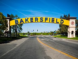
Downtown is the central business district for Bakersfield, California. It contains several of the city's major theaters, sports complex, museums, and historical landmarks.
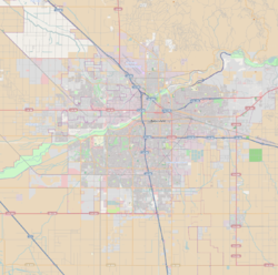
What is considered to be "downtown" Bakersfield varies. Starting from the north and traveling clockwise, Central Bakersfield is bound by the Kern River, Union Avenue, State Route 58, and State Route 99. The Downtown Business Association defines downtown Bakersfield as the region bordered by 24th Street (SR 178), Union Avenue (SR 204), California Avenue, and F Street. [1] Other people extend the boundaries west to State Route 99 and north to Golden State Avenue (SR 204).
There are a few tall buildings in Downtown Bakersfield, such as the Bank of America Building (10 stories), the Bakersfield Marriott Hotel (9 stories), and The Padre Hotel (8 stories). The shops and cafes that line the Downtown streets feature dining and shopping venues. Notable attractions in Downtown Bakersfield include the Rabobank Arena, the McMurtrey Aquatic Center, the Bakersfield Museum of Art, the historic Fox Theater, the Padre Hotel, and a nightlife district centered on 19th Street and Wall Street Alley. [2]
The Arts District is roughly bordered by 21st Street, Chester Avenue, 17th Street, and G Street. Theaters in the district include the Fox Theater (20th and H streets), Stars Theater (Chester Avenue and 20th Street), and Spotlight Theater (19th and H streets). In addition, several art galleries are located around the intersection of 19th Street and Eye Street. [3] The Arts District has the historic Padre Hotel, which has been remodeled and reopened as a boutique hotel. [4]
Civic Center is the center of government for both the City of Bakersfield and the County of Kern. It is roughly bordered by Truxtun Avenue, Q Street, the BNSF railroad yard, and H Street. Major government buildings include Bakersfield City Hall, County of Kern Administrative Building, Kern County Hall of Records, Superior Court, and Municipal Court.
Although structures representing the center of government, such as City Hall and the Court House, are located there, many services are being moved to other places throughout the city. Many state and federal services are also placed in locations outside of the Civic Center. Civic Center houses the Rabobank Theater and Convention Center (formerly known as the Civic Auditorium). This is the largest theater and convention facility in the city. It is located next to the Marriott Convention Hotel.
The Rabobank Arena (formerly known as the Centennial Garden) is a large indoor multipurpose arena. [5] The McMurtrey Aquatic Center houses a 50-meter competition swimming and diving pool. [6] There is also the Bakersfield Ice Sports Center, an indoor ice rink used for junior and adult league hockey and recreation. [7]
Education District is the center of education institutions that are located Downtown. Currently five institutions have a campus or a satellite campus in the district. The Education District is roughly bordered by 24th Street, Q Street, 20th Street, and Chester Avenue.
Mill Creek is another one of Downtown's districts and is still being developed. When fully completed, Mill Creek can consist of a mixture of both commercial and retail. The redevelopment area is defined to be Golden State Avenue, Union Avenue, California Avenue, and Q Street. [8] Running through the center of Mill Creek is the Mill Creek Linear Park. This runs along the man-made Kern Island Canal, which has been redesigned to have the look of a natural river.
A major attraction in the area is the Bakersfield Museum of Art. The Beale Memorial Library, which is the headquarters for the Kern County Library System, is also located in Mill Creek. Another structure is the Amtrak station, which is Bakersfield's rail link to the San Joaquin Valley.
The following are neighborhoods and districts which are near Downtown Bakersfield. Some people consider them to be a part of Downtown.
Formerly named Pierce Road, Buck Owens Boulevard was renamed in 1998 in honor of long-time Bakersfield resident and country music legend Buck Owens, who died in 2006. [9] Buck Owens Boulevard runs north/south, parallel to Highway 99, between Rosedale Highway/24th Street in Bakersfield, and Airport Drive in Oildale. Buck Owens Boulevard is located near Beach Park and is the heart of Bakersfield's Country Music scene. [9]
The main attractions in the area are the original Bakersfield Sign (formerly located at the intersection of California and Union Avenues) and the Buck Owens Crystal Palace. [10]
The Westchester neighborhood is just west of Downtown Bakersfield, although some people consider it to be part of Downtown. Westchester is bounded by the Kern River, F Street, the BNSF Railroad Yard and State Route 99 (or Oak Street). [11] Main points of interest include the Kern County Museum (with the Beale Memorial Clock Tower), and Sam Lynn Ballpark.
The Oleander-Sunset neighborhood is located in central Bakersfield and sits on the southern end of downtown Bakersfield. The Oleander-Sunset Area consists of two neighborhoods: the Lowell Community and the Oleander Community. Oleander-Sunset is bounded by California Avenue, Union Avenue, Highway 58, and Highway 99. [12] It contains Lowell Park, Beale Park, Mount Zion Baptist Church, Lowell Place Senior Community, Bakersfield High School, Vista P. Continuation High School, Rafer Johnson Community School, Emerson Junior High School, Roosevelt Elementary, McKinley Elementary, William Penn Elementary, the Lowell Neighborhood Community Center, the Ebony Counseling Center, and the Kern County Black Chamber of Commerce. [13] [14] [15]
The Oleander-Sunset suburbs may refer to the Oleander area only. The Oleander neighborhood is traditionally bounded by California Avenue on the north, H Street on the east, State Route 58 on the south, and Oak Street on the west. Meanwhile, the Lowell Community is bounded by California Avenue, Union Avenue, State Route 58, and H Street.
Bakersfield's historic Chinatown was a nine square-block district bordered roughly by 20th and 23rd streets and N and K streets. [16]
State Route 178 ends at the eastern edge of downtown and provides a connection to the northeast. State Route 99 runs approximately a half-mile west of downtown and provides a north-south connection to the rest of the city. Golden State Ave (State Route 204), as a freeway ends at the north edge of downtown and provides access to the northwest.
Golden Empire Transit (GET) provides transportation to Greater Bakersfield from the downtown transit center. [17] Kern Regional Transit provides intercity transportation from the GET downtown transit center or Amtrak station. [18] Amtrak provides rail connections to the San Joaquin Valley north of Bakersfield and several bus routes to points west, south, and east of the city. [19] SR 178 and Golden State Avenue (SR 204) stop at the edge of Downtown.
Kern County is a county located in the U.S. state of California. As of the 2020 census, the population was 909,235. Its county seat is Bakersfield.
Bakersfield is a city in and the county seat of Kern County, California, United States. The city covers about 151 sq mi (390 km2) near the southern end of the San Joaquin Valley, which is located in the Central Valley region.
State Route 178 is a state highway in the U.S. state of California that exists in two constructed segments. The gap in between segments is connected by various local roads and State Route 190 through Death Valley National Park. The western segment runs from State Route 99 in Bakersfield and over the Walker Pass in the Sierra Nevada to the turnoff for the Trona Pinnacles National Natural Landmark. The eastern segment runs from the southeasterly part of Death Valley to Nevada State Route 372 at the Nevada state line.
Downtown Albuquerque is the central business district of Albuquerque, New Mexico, United States. It is where a significant number of the city's highrise buildings are located, and is the center of government and business for the Greater Albuquerque metropolitan region.
Bakersfield station is an intermodal facility in Bakersfield, California. It is the southern terminus of Amtrak California's San Joaquins route, with Amtrak Thruway buses continuing to Amtrak stations and bus stops throughout Southern California and Nevada. The station opened with a celebration on July 4, 2000. It contains an 8,300-square-foot (770 m2) train station with two platforms and three tracks, as well as a 17-bay bus station.
East Bakersfield is a region in Bakersfield, California directly east of downtown. The region was formerly known as the town of Sumner, which was later incorporated and renamed Kern City. It is primarily a mixture of residential and commercial developments. It also contains a small business district centered on the intersection of Baker and Sumner streets. Census data is provided on the right for the time period when the region was an independent town and city. It is part of the Bakersfield urban area of almost 500,000 people.
Robert J. Cabral Station, is a railway station in Stockton, California. In 2003, the station building was named in honor of the late Robert J. Cabral, a San Joaquin County supervisor instrumental in the creation of the Altamont Corridor Express (ACE), originally Altamont Commuter Express.
Golden Empire Transit is the operator of mass transportation in Bakersfield, California. There are 16 routes serving Greater Bakersfield, which includes both the City of Bakersfield and adjacent unincorporated communities. Since 2005, almost the entire bus fleet has been powered by compressed natural gas. In 2021, 5 hydrogen buses were added to the fleet, with an additional 5 planned for purchase in the future. In 2023, the system had a ridership of 3,531,400, or about 11,800 per weekday as of the first quarter of 2024.
Kern Transit, formerly Kern Regional Transit, is the operator of mass transportation in Kern County, California. Primarily, it provides inter-regional transportation, connecting outlying regions with the city of Bakersfield. It also provides inter-city transportation within specific regions. Kern (Regional) Transit is operated by the Kern County Department of Roads. The agency was founded in 1981. Its headquarters are located in Bakersfield.
Mill Creek is a linear park located in Bakersfield, California. It runs along the Kern Island Canal between Golden State Avenue and California Avenue in downtown, although there is a gap between 19th Street and the BNSF railroad yard. The center of the park is Central Park, the only park in downtown. The park contains a lake with spray fountains and the “Mill Creek” bridge. It is also home to the Bakersfield Museum of Art and the Bakersfield Community House.
Kern County’s transportation system was quoted as the “unseen industry.” Located at the southern end of the San Joaquin Valley, the county is at a prime location to ship goods west to the central coast, south to ports in Los Angeles, and east to corridors that connect to the rest of the country. It is also on major corridors that link to all northern points.
The Bakersfield Sign is one of the most recognizable landmarks in Bakersfield, California. It is located over Sillect Avenue, where the street intersects with Buck Owens Boulevard, to the northwest of Downtown Bakersfield. The sign can be seen from State Route 99 and is just past the freeway off-ramp. It is also next to the Buck Owens Crystal Palace.
Southwest Bakersfield is the southwest region of Bakersfield, California. It is roughly bounded by the Kern River to the north and Oak Street/Wible Road to the east. The other boundaries are the city limits themselves.
Northeast Bakersfield is the northeast region of Bakersfield, California. It is roughly bounded by Panorama Drive and the Kern River to the north, Alfred Harrell Highway/Comanche Drive to the east, Edison Highway to the south, and Union Avenue to the west. The region of East Bakersfield is located within these boundaries but is usually not considered part of the Northeast. Instead, the Northeast wraps around the boundaries of East Bakersfield. Other boundaries are the city limits.
Bakersfield provides a wide variety of arts and culture.
Arts District is a district in Downtown Bakersfield, California, USA. It is a major center for visual and performing arts. Several art galleries are located in the district, with most of them centered on the intersection of 19th Street and Eye Street. Several theater groups are also located in the district. Its boundaries are marked with banners, which were erected by the Arts Council of Kern.
Mill Creek is a district in Downtown Bakersfield, California. It is primarily a mixture of residential and commercial on the east side of downtown. Since the mid-2000s, the district has gone through major redevelopment. These included, the development of the Kern Island Canal into a walking path, the redevelopment of Central Park, construction of the Federal Courthouse, and construction of several new housing and commercial developments.
The following is a timeline of the history of the city of Bakersfield, California, USA.