Northwest Bakersfield

Last updated
Northwest Bakersfield
Location map Bakersfield.png
Red pog.svg
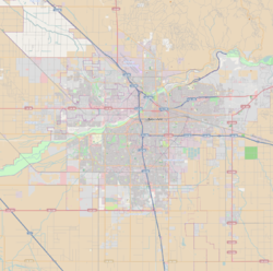
Northwest Bakersfield
Location within Bakersfield
Coordinates: 35°24′0″N119°6′14″W / 35.40000°N 119.10389°W / 35.40000; -119.10389
CountryUnited States
StateCalifornia
County County of Kern
City City of Bakersfield
Neighborhoods of Northwest
List
  • Bakersfield Commons
  • Riverlakes Ranch
Area
  Total28.14 sq mi (72.9 km2)
 Includes area scheduled for future development.
ZIP Code
93308, 93312, 93314
Area Code 661

Northwest Bakersfield (commonly referred to simply as The Northwest) is the northwest region of Bakersfield, California. It is bounded by the Kern River/Stockdale Highway to the south and State Route 99 to the east. The other boundaries are the city limits themselves.

Contents

Historically, this region was rural, with the farming communities of Fruitvale, Rosedale, and Greenacres. However, starting in the mid-1990s, this region started experiencing significant growth. The city limits have reached the boundaries of these communities.

The area incorporated by the city is primarily residential and retail, including some commercial. The area that is unincorporated is primarily industrial.

Neighborhoods

Bakersfield Commons

Bakersfield Commons is a planned mixed-use project in the northwest. Its exact boundaries are currently unknown, but it will encompass land at the intersection of Coffee Road and Brimhall Road. The development will be constructed in three phases and take approximately 20 years to complete. [1] It will employ a building policy where residential, commercial, and retail spaces will be constructed closely together to allow for easy access by foot.

Bakersfield Commons will also feature a new retail shopping center. Its design will emulate a main street, similar to The Grove in Los Angeles. According to advertisements from the developer, the goal will be to attract new businesses from outside the city rather than adding locations for existing businesses. [2]

Riverlakes Ranch

Riverlakes Ranch is a neighborhood in the northwest. Starting north and traveling clockwise, it is roughly bounded by Olive Drive, Coffee Road, Rosedale Highway, and Allen Road. East of Coffee Road, there is a small segment that extends south to Fruitvale Avenue, next to the town of Fruitvale. It is a mixture of residential, commercial, and retail developments. The centerpiece of Riverlakes Ranch is The Links at Riverlakes Ranch public golf course. The design of the course was inspired by Scottish golf courses. [3] Riverlakes Ranch also contains the Northwest Promenade, a shopping center nearly a mile long that contains anchors such as Walmart, Target, The Home Depot, Office Depot, Ross Dress for Less, Kohl's, Best Buy, Petco, Dick's Sporting Goods, and Cost Plus World Market.

Related Research Articles

<span class="mw-page-title-main">Yonge Street</span> Historic road in Ontario, Canada

Yonge Street is a major arterial route in the Canadian province of Ontario connecting the shores of Lake Ontario in Toronto to Lake Simcoe, a gateway to the Upper Great Lakes.

<span class="mw-page-title-main">Kanata, Ontario</span> Place in Ontario, Canada

Kanata is a suburb and former city within Ottawa, Ontario, Canada. It is located about 22 km (14 mi) west of the city's downtown core. As of 2021, the former City of Kanata had a population of 98,938, with the population centre having a population of 137,118. Before it was amalgamated into Ottawa in 2001, it was one of the fastest-growing cities in Canada and the fastest-growing community in Eastern Ontario. Located just to the west of the National Capital Commission Greenbelt, it is one of the largest of several communities that surround central Ottawa.

<span class="mw-page-title-main">York Mills</span> Neighbourhood in Toronto, Ontario, Canada

York Mills is a neighbourhood in Toronto, Ontario, Canada. It is centred around Yonge Street and York Mills Road located in the district of North York. In 2010, it encompassed the fourth and seventh most affluent postal codes in Canada. It is recognized as a millionaires' mile, alongside the other Toronto neighbourhoods of The Bridlepath, Forest Hill, and Rosedale.

<span class="mw-page-title-main">Bloor Street</span> Major thoroughfare in Toronto

Bloor Street is a major east–west residential and commercial thoroughfare in Toronto, Ontario, Canada. Bloor Street runs from the Prince Edward Viaduct, which spans the Don River Valley, westward into Mississauga where it ends at Central Parkway. East of the viaduct, Danforth Avenue continues along the same right-of-way. The street, approximately 25 kilometres (16 mi) long, contains a significant cross-sample of Toronto's ethnic communities. It is also home to Toronto's famous shopping street, the Mink Mile.

<span class="mw-page-title-main">Brookhaven, Georgia</span> City in Georgia, United States

Brookhaven is a city in the northeastern suburbs of Atlanta that is located in western DeKalb County, Georgia, United States, directly northeast of Atlanta. On July 31, 2012, Brookhaven was approved in a referendum to become DeKalb County's 11th city. Incorporation officially took place on December 17, 2012, on which date municipal operations commenced. With a population of around 55,366 as of 2021, it is the largest city in DeKalb County. The new city stretches over 12 square miles (31 km2).

<span class="mw-page-title-main">Canning Vale, Western Australia</span> Suburb of Perth, Western Australia

Canning Vale is a southern suburb of Perth, 22 km (13.7 mi) from the central business district. Its local government areas are the City of Canning and the City of Gosnells.

<span class="mw-page-title-main">Southfield Town Center</span> Office/hotel/retail in the United States

The Southfield Town Center is a cluster of five interconnected skyscrapers forming a contemporary 2,200,000-square-foot (204,400 m2) office complex in the Detroit suburb of Southfield, Michigan. It includes the Westin Southfield Detroit Hotel, restaurants, a fitness center, and a major conference center for up to 1,000 attendees. This office-hotel complex is situated along Town Center Drive off M-10, across from Lawrence Technological University in Metro Detroit, with many of its tallest buildings named after their addresses along the road. Separately, there is a 33-story luxury residential high-rise at 5000 Town Center. The American Center, another 26-story office tower near the confluence of Interstate 696 (I-696) and M-10, is not part of the complex.

Mayor Magrath Drive is the busiest north–south roadway and the second busiest roadway overall in Lethbridge, Alberta. In 2011, it saw roughly 34,000 vehicles per day in weekday traffic. Most retail and hospitality establishments in the city are concentrated on this roadway, and it serves as a major transportation corridor for the city and region.

Liberty Station is a mixed-use development in San Diego, California, on the site of the former Naval Training Center San Diego. It is located in the Point Loma community of San Diego. It has a waterfront location, on a boat channel off of San Diego Bay, just west of the San Diego Airport and a few miles north of Downtown San Diego. The 361-acre (1.46 km2) project includes several distinct districts: a retail and commercial district, a promenade focused on nonprofit activities, an arts district, educational district, residential district, hotel district, office district, and a park/open space area along the boat channel.

<span class="mw-page-title-main">Development in Abilene, Texas</span>

Abilene, Texas, has steadily become the retail, residential, business, medical, and overall center of the surrounding Big Country. Commercial development was especially boosted in 2007, with several multimillion-dollar projects throughout the entire city. Most of the recent development is concentrated in roughly four areas in Abilene: Southwest Drive, Catclaw Drive, and Buffalo Gap Road near the Winters Freeway to the southwest, as this area becomes a strong commercial sector as well as a good residential district; Buffalo Gap Road, Beltway South, and US Highway 83/84 near and beyond the outskirts of the city in the south with several housing developments; Loop 322 area and Oldham Ln to the southeast, also near and past the edge of the city with a mix of several residential subdivisions as well as the start of commercial growth; and State Highway 351/Ambler Avenue near Interstate 20 to the northeast, also a combination of staple retail development, similar to the southwest commercial development, and the beginnings of residential growth with a new apartment complex and growing subdivisions.

<span class="mw-page-title-main">Fruitvale Oil Field</span> Oil and gas field in the San Joaquin Valley, California, USA

The Fruitvale Oil Field is a large oil and gas field in the southern San Joaquin Valley, California, within and just northwest of the city of Bakersfield, along and north of the Kern River. It is one of the few oil fields in the California Central Valley which is mostly surrounded by a heavily populated area. Discovered in 1928, and with a cumulative total recovery of more than 124 million barrels (19,700,000 m3) of oil at the end of 2006, it is 41st in size among California oil fields, and according to the California Department of Oil, Gas, and Geothermal Resources (DOGGR) its total reserve amounts to a little less than ten percent of its original oil.

<span class="mw-page-title-main">Downtown Bakersfield</span> Place in California, United States

Downtown is the central business district for Bakersfield, California. It contains several of the city's major theaters, sports complex, museums, and historical landmarks.

Southwest Bakersfield is the southwest region of Bakersfield, California. It is roughly bounded by the Kern River to the north and Oak Street/Wible Road to the east. The other boundaries are the city limits themselves.

Northeast Bakersfield is the northeast region of Bakersfield, California. It is roughly bounded by Panorama Drive and the Kern River to the north, Alfred Harrell Highway/Comanche Drive to the east, Edison Highway to the south, and Union Avenue to the west. The region of East Bakersfield is located within these boundaries but is usually not considered part of the Northeast. Instead, the Northeast wraps around the boundaries of East Bakersfield. Other boundaries are the city limits.

The community of Forest Park consists of almost 2900 private residential properties, plus apartments, condominiums, commercial properties, city-owned parks and schools, in approximately 1.4 square miles (3.6 km2) of the Northland area of northeast Columbus, Ohio. These properties adjoin a total of 132 distinct streets and courts maintained by the City of Columbus. The community's approximate center is near the intersection of Karl Road and Sandalwood Place in Columbus.

Bakersfield is home to several minor league sports franchises and collegiate athletic programs at Bakersfield College and California State University, Bakersfield.

<span class="mw-page-title-main">Aspen Ridge, Saskatoon</span> Neighbourhood in Saskatoon, Saskatchewan, Canada

Aspen Ridge is a neighbourhood located in northeast Saskatoon, Saskatchewan, Canada, construction on which began in 2014. At full build-out, Aspen Ridge will eventually house an estimated 13,000 people. Unlike many of the city's suburban neighbourhoods, it will feature higher density housing on a grid network of roads.

Arabian Ranches is an upscale gated villa community in Dubai, United Arab Emirates launched in 2004. Located in Wadi Al Safa 6, along Sheikh Mohammad Bin Zayed Road and in proximity to Dubai's Global Village. It includes the Arabian Ranches Golf Club, Dubai Polo & Equestrian Club.

Teddington Park is a neighbourhood in Toronto, Ontario, Canada. It is bordered by Yonge Street to the west and Bayview Avenue to the east, and from Snowden Road in the south to north of Glen Echo Road and Rosedale Golf Club. Development occurred in and around the 1930s, and was farmland before that time.

References

  1. The Three Phases. Bakersfield Commons. Accessed: 05-17-2010.
  2. Retail Component. Bakersfield Commons. Accessed: 05-17-2010.
  3. Home Page. The Links at Riverlakes Ranch. Accessed: 05-17-2010.