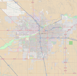
Bakersfield is a city in and the county seat of Kern County, California, United States. The city covers about 151 sq mi (390 km2) near the southern end of the San Joaquin Valley, which is located in the Central Valley region.
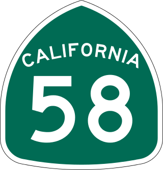
State Route 58 is a major east-west state highway in the U.S. state of California that runs across the Coast Ranges, the southern San Joaquin Valley, the Tehachapi Mountains, which border the southern Sierra Nevada, and the Mojave Desert. It runs between U.S. Route 101 near Santa Margarita and Interstate 15 in Barstow. It has junctions with Interstate 5 near Buttonwillow, State Route 99 in Bakersfield, State Route 202 in Tehachapi, State Route 14 near Mojave, and U.S. Route 395 at Kramer Junction. SR 58 also provides access to Edwards Air Force Base. At various points it is known as the Calf Canyon Highway, Carrisa Highway, Bakersfield-McKittrick Highway, Rosa Parks Highway, Westside Parkway, Barstow-Bakersfield Highway, Bakersfield Tehachapi Highway, Kern County Korean War Veterans Memorial Highway, and Mojave-Barstow Highway.
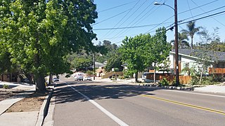
The College Area is a residential community in the Mid-City region of San Diego, California, United States. It is dominated by San Diego State University (SDSU), after which the area is named. Several neighborhoods in the College Area were developed in the 1930s, with others becoming established in the post-war period.
The City of Oklahoma City uses Special Zoning Districts as a tool to maintain the character of many neighborhood communities.
Stockdale High School (SHS) is an American senior high school located in Bakersfield, California. Its athletics teams are known as the Stockdale Mustangs and the school colors are black and silver. Stockdale High School first opened in 1991. Now in its 28th year, with approximately 2,069 students enrolled, Stockdale has an API of 831. Sixty-four sections of GATE, Honors, and Advanced Placement classes are offered for the college-bound. For students interested in career pathways, eight courses are offered, including Agricultural Science and Technology, Applied Engineering and Design, Computer and Commercial Graphics, Computer Science and Information Systems, Accounting and Finance, Medicine, Virtual Business Enterprise, and Construction Technology. The school motto is "Branded by Excellence." In 2010, Newsweek ranked Stockdale among the top 6 percent of all public schools in the United States.

Downtown Columbus is the central business district of Columbus, Ohio. Downtown is centered on the intersection of Broad and High Streets, and encompasses all of the area inside the Inner Belt. Downtown is home to most of the tallest buildings in Columbus.
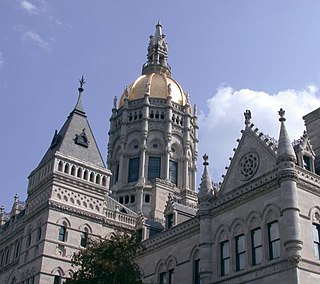
The neighborhoods of Hartford, Connecticut in the United States are varied and historic.
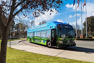
Golden Empire Transit is the operator of mass transportation in Bakersfield, California. There are 16 routes serving Greater Bakersfield, which includes both the City of Bakersfield and adjacent unincorporated communities. Since 2005, almost the entire bus fleet has been powered by compressed natural gas. In 2021, 5 hydrogen buses were added to the fleet, with an additional 5 planned for purchase in the future. In 2023, the system had a ridership of 3,531,400, or about 11,400 per weekday as of the third quarter of 2024.
The Park at River Walk is a public park located in Bakersfield, California. The park is 32 acres (130,000 m2), and contains two lakes connected by a stream. It is also the location of the Spectrum Amphitheater, one of two large outdoor theaters in Bakersfield. The park is located next to the Kern River Bike Trail. It is also located near the Calloway Drive Interchange for the Westside Parkway.
Mill Creek is a linear park located in Bakersfield, California. It runs along the Kern Island Canal between Golden State Avenue and California Avenue in downtown, although there is a gap between 19th Street and the BNSF railroad yard. The center of the park is Central Park, the only park in downtown. The park contains a lake with spray fountains and the “Mill Creek” bridge. It is also home to the Bakersfield Museum of Art and the Bakersfield Community House.

Kern County’s transportation system was quoted as the “unseen industry.” Located at the southern end of the San Joaquin Valley, the county is at a prime location to ship goods west to the central coast, south to ports in Los Angeles, and east to corridors that connect to the rest of the country. It is also on major corridors that link to all northern points.

Downtown is the central business district for Bakersfield, California. It contains several of the city's major theaters, sports complex, museums, and historical landmarks.
Northeast Bakersfield is the northeast region of Bakersfield, California. It is roughly bounded by Panorama Drive and the Kern River to the north, Alfred Harrell Highway/Comanche Drive to the east, Edison Highway to the south, and Union Avenue to the west. The region of East Bakersfield is located within these boundaries but is usually not considered part of the Northeast. Instead, the Northeast wraps around the boundaries of East Bakersfield. Other boundaries are the city limits.
Northwest Bakersfield is the northwest region of Bakersfield, California. It is bounded by the Kern River/Stockdale Highway to the south and State Route 99 to the east. The other boundaries are the city limits themselves.
Stine Canal is an irrigation canal in Kern County, California. It originates from the Carrier Canal adjacent to SR 99. It terminates at a reservoir on Bear Mountain Boulevard, just east of Gosford Road.

The Highland Park Historic Business District at Euclid and Sixth Avenues is located in the north-central section of Des Moines, Iowa, United States. It is located on the border of the Oak Park and Highland Park neighborhoods. The commercial historic district has been listed on the National Register of Historic Places since 1998. The Highland Park neighborhood also includes the College Corner Commercial Historic Business District.
Riverside and Avondale are two adjacent and closely associated neighborhoods, alternatively considered one continuous neighborhood, of Jacksonville, Florida. The area is primarily residential, but includes some commercial districts, including Five Points, the King Street District, and the Shoppes of Avondale.

OliverMcMillan, established in 1978, is a private real estate development firm based in San Diego, California. It creates mixed-use retail, entertainment, and residential projects, both privately and through public-private partnerships with public entities and redevelopment agencies across the U.S. OliverMcMillan has received four national industry design awards and more than 50 regional industry design awards over the past 35 years. The firm has designed and developed more than eight million square feet of projects, with a total project value exceeding $3 billion. As of 2014, OliverMcMillan has approximately $2 billion in real estate projects under development in major U.S. cities, including Houston, San Diego, Honolulu, Atlanta and Phoenix.