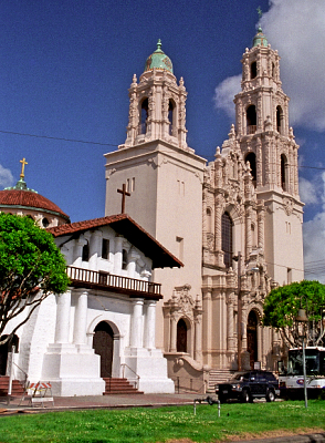
Mission San Francisco de Asís, commonly known as Mission Dolores, is a Spanish Californian mission and the oldest surviving structure in San Francisco. Located in the Mission District, it was founded on October 9, 1776, by Padre Francisco Palóu and co-founder Fray Pedro Benito Cambón, who had been charged with bringing Spanish settlers to Alta California and with evangelizing the local indigenous Californians, the Ohlone. The present mission building was the second structure for the site and was dedicated in 1791.

Mission San Francisco Solano was the 21st, last, and northernmost mission in Alta California. It was named for Saint Francis Solanus. It was the only mission built in Alta California after Mexico gained independence from Spain. The difficulty of its beginning demonstrates the confusion resulting from that change in governance. The California Governor wanted a robust Mexican presence north of the San Francisco Bay to keep the Russians who had established Fort Ross on the Pacific coast from moving further inland. A young Franciscan friar from Mission San Francisco de Asis wanted to move to a location with a better climate and access to a larger number of potential converts.
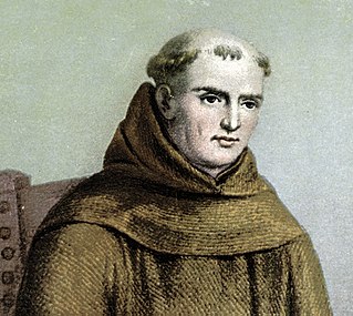
Junípero Serra y Ferrer, popularly known simply as Junipero Serra, was a Spanish Catholic priest and missionary of the Franciscan Order. He is credited with establishing the Franciscan Missions in the Sierra Gorda, a UNESCO World Heritage Site. He later founded a mission in Baja California and the first nine of 21 Spanish missions in California from San Diego to San Francisco, in what was then Spanish-occupied Alta California in the Province of Las Californias, New Spain.

Bakersfield is a city in Kern County, California, United States. It is the county seat and largest city of Kern County. The city covers about 151 sq mi (390 km2) near the southern end of the San Joaquin Valley and the Central Valley region. Bakersfield's population as of the 2020 census was 403,455, making it the 48th most populous city in the United States of America and the 9th most populous city in California. The Bakersfield–Delano Metropolitan Statistical Area, which includes all of Kern County, had a 2020 census population of 909,235, making it the 62nd largest metropolitan area in the United States. The urban area that includes Bakersfield and areas immediately around the city, such as East Bakersfield, Oildale, and Rosedale, has a population of 570,235.

El Camino Real is a 600-mile (965-kilometer) commemorative route connecting the 21 Spanish missions in California, along with a number of sub-missions, four presidios, and three pueblos. Sometimes associated with Calle Real, its southern end is at Mission San Diego de Alcalá and its northern terminus is at Mission San Francisco Solano.

State Route 99 (SR 99) is a north–south state highway in the U.S. state of California, stretching almost the entire length of the Central Valley. From its southern end at Interstate 5 (I-5) near Wheeler Ridge to its northern end at SR 36 near Red Bluff, SR 99 goes through the densely populated eastern parts of the valley. Cities served include Bakersfield, Delano, Tulare, Visalia, Fresno, Madera, Merced, Turlock, Modesto, Manteca, Stockton, Sacramento, Yuba City, and Chico.

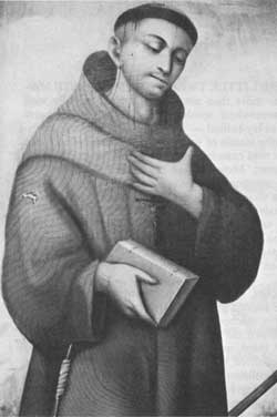
Francisco Hermenegildo Tomás GarcésO.F.M. was a Spanish Franciscan friar who served as a missionary and explorer in the colonial Viceroyalty of New Spain. He explored much of the southwestern region of North America, including present day Sonora and Baja California in Mexico, and the U.S. states of Arizona and California. He was killed along with his companion friars during an uprising by the Native American population, and they have been declared martyrs for the faith by the Catholic Church. The cause for his canonization was opened by the Church.
Pedro Fages (1734–1794) was a Spanish soldier, explorer, first Lieutenant Governor of the Californias under Gaspar de Portolá. Fages claimed the governorship after Portolá's death, acting as governor in opposition to the official governor Felipe de Barri, and later served officially as fifth (1782–91) Governor of the Californias.

The Juan Bautista de Anza National Historic Trail is a 1,210-mile (1,950 km) trail extending from Nogales on the U.S.-Mexico border in Arizona, through the California desert and coastal areas in Southern California and the Central Coast region to San Francisco. The trail commemorates the 1775–1776 land route that Spanish commander Juan Bautista de Anza took from the Sonora y Sinaloa Province of New Spain in Colonial Mexico through to Las Californias Province. The goal of the trip was to establish a mission and presidio on the San Francisco Bay. The trail was an attempt to ease the course of Spanish colonization of California by establishing a major land route north for many to follow. It was used for about five years before being closed by the Quechan (Yuma) Indians in 1781 and kept closed for the next 40 years. It is a National Historic Trail administered by the National Park Service and was also designated a National Millennium Trail.

A California Historical Landmark (CHL) is a building, structure, site, or place in California that has been determined to have statewide historical landmark significance.

State Route 204 is a state highway in the U.S. state of California that connects SR 58 and SR 99 in the Bakersfield area. Passing through downtown Bakersfield, SR 204 also connects Bakersfield's three major freeways together. Only the northern 1.4 miles (2.3 km) has been built to freeway standards; the rest is a six-lane arterial road.

Garces Memorial High School, commonly shortened to Garces High School, is a Catholic high school in Bakersfield, California.
The Los Alamitos Traffic Circle, informally known as the Long Beach Traffic Circle, is a roundabout at the intersection of Lakewood Boulevard, Pacific Coast Highway and Los Coyotes Diagonal in Long Beach, California. The intersection was originally constructed as a traffic circle in 1930 and reconstructed as a modern roundabout in 1993.
Mission San Pedro y San Pablo de Bicuñer was founded on January 7, 1781, by Spanish Padre Francisco Garcés, to protect the Anza Trail where it forded the Colorado River, between the Mexican provinces of Alta California and New Navarre.
San Miguel de los Noches was an Indian rancheria in Kern County, California. Its site is covered by the modern-day city of Bakersfield.

Kern County’s transportation system was quoted as the “unseen industry.” Located at the southern end of the San Joaquin Valley, the county is at a prime location to ship goods west to the central coast, south to ports in Los Angeles, and east to corridors that connect to the rest of the country. It is also on major corridors that link to all northern points.

Downtown is the central business district for Bakersfield, California. It contains several of the cities major theaters, sporting complexes, museums, and historical landmarks.
Tejon Creek, originally in Spanish Arroyo de Tejon, is a stream in Kern County, California. Its headwaters are located on the western slopes of the Tehachapi Mountains, and it flows northwest into the southern San Joaquin Valley.

Monument Peak is a summit in the San Bernardino Mountains, of San Bernardino County, California. It lies at an elevation of 5272 feet.

Kaawchama, alternatively referred to as Wa’aachnga, was a significant Tongva village in the San Bernardino Valley located in what is now west Redlands, California. The village became referred to by the Spanish as the Guachama Rancheria in 1810 after a supply station was constructed at the village for Mission San Gabriel, which then became part of Rancho San Bernardino following the secularization of the missions in 1833.


