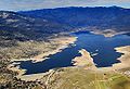
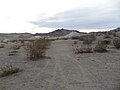
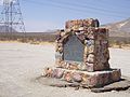
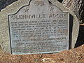
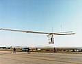
Image [ 1] Landmark name Location City or town Summary 20 Mule Team Borax Terminus 652 20 Mule Team Borax Terminus 16246 Sierra Hwy. 35°03′24″N 118°10′31″W / 35.056767°N 118.17525°W / 35.056767; -118.17525 (20 Mule Team Borax Terminus ) Mojave Bealville 741 Bealville Bealville Rd. 35°16′19″N 118°37′34″W / 35.271917°N 118.626217°W / 35.271917; -118.626217 (Bealville ) Caliente Buena Vista Refinery 504 Buena Vista Refinery Hwy 33 & LoKern Rd. 35°23′52″N 119°39′54″W / 35.3977°N 119.665°W / 35.3977; -119.665 (Buena Vista Refinery ) McKittrick Buttonwillow Tree 492 Buttonwillow Tree Buttonwillow Dr. 35°24′25″N 119°28′27″W / 35.406867°N 119.474217°W / 35.406867; -119.474217 (Buttonwillow Tree ) Buttonwillow Caliente 757 Caliente 35°17′26″N 118°37′36″W / 35.2905°N 118.626683°W / 35.2905; -118.626683 (Caliente ) Caliente California Standard Oil Well 1 376 California Standard Oil Well 1 McKittrick Oil Field 35°17′54″N 119°38′02″W / 35.2982027777778°N 119.634011111111°W / 35.2982027777778; -119.634011111111 (California Standard Oil Well 1 ) McKittrick Campsite of Edward M. Kern 742 Campsite of Edward M. Kern Old Isabella Road Recreation Area 35°38′58″N 118°27′30″W / 35.649583°N 118.458233°W / 35.649583; -118.458233 (Campsite of Edward M. Kern ) Lake Isabella Colonel Thomas Baker Memorial 382 Colonel Thomas Baker Memorial Bakersfield City Hall 35°22′23″N 119°01′10″W / 35.37305°N 119.019317°W / 35.37305; -119.019317 (Colonel Thomas Baker Memorial ) Bakersfield Desert Spring 476 Desert Spring Pappas Ranch on Pappas Rd. 35°18′06″N 117°57′15″W / 35.301783°N 117.95425°W / 35.301783; -117.95425 (Desert Spring ) Cantil Discovery well of Kern River Oilfield 290 Discovery well of Kern River Oilfield Round Mountain Rd. 35°25′42″N 118°57′17″W / 35.4282°N 118.95485°W / 35.4282; -118.95485 (Discovery well of Kern River Oilfield ) Bakersfield Appointment must be made to view. Fages-Zalvidea Crossing 291 Fages-Zalvidea Crossing State Hwy 166 35°03′33″N 119°04′00″W / 35.059233°N 119.066583°W / 35.059233; -119.066583 (Fages-Zalvidea Crossing ) Bakersfield Fort Tejon 129 Fort Tejon Fort Tejón State Historic Park 34°52′24″N 118°53′44″W / 34.873233°N 118.8955°W / 34.873233; -118.8955 (Fort Tejon ) Lebec Also on the NRHP list as NPS-71000140 Freeman Junction 766 Freeman Junction Historic district 35°36′07″N 117°54′26″W / 35.602067°N 117.907217°W / 35.602067; -117.907217 (Freeman Junction ) Inyokern Garcés Baptismal Site 631 Garcés Baptismal Site State Hwy 155 35°44′48″N 118°55′34″W / 35.746712°N 118.926144°W / 35.746712; -118.926144 (Garcés Baptismal Site ) Woody Garcés Circle 277 Garcés Circle Chester Ave & 30th St. 35°23′13″N 119°01′08″W / 35.387°N 119.019°W / 35.387; -119.019 (Garcés Circle ) Bakersfield Site of the town of Garlock 671 Site of the town of Garlock Historic district 35°24′09″N 117°47′26″W / 35.402417°N 117.79045°W / 35.402417; -117.79045 (Site of the town of Garlock ) Randsburg Glennville Adobe 495 Glennville Adobe Kern County Fire Department Glennville Substation 35°43′36″N 118°42′02″W / 35.726667°N 118.700633°W / 35.726667; -118.700633 (Glennville Adobe ) Glennville Gordon's Ferry 137 Gordon's Ferry Kern River 35°25′29″N 118°58′05″W / 35.4248°N 118.968067°W / 35.4248; -118.968067 (Gordon's Ferry ) Bakersfield Havilah 100 Havilah Miller St. & Kern River Canyon Rd. 35°31′06″N 118°30′59″W / 35.5182°N 118.5163°W / 35.5182; -118.5163 (Havilah ) Caliente Indian Wells 457 Indian Wells Indian Wells Lodge, 2565 Aerospace Highway 35°40′04″N 117°52′20″W / 35.667867°N 117.87235°W / 35.667867; -117.87235 (Indian Wells ) Inyokern Kern River Slough Station 588 Kern River Slough Station Panama Rd. 35°15′35″N 118°58′03″W / 35.259722°N 118.9675°W / 35.259722; -118.9675 (Kern River Slough Station ) Lamont Kernville 132 Kernville Old Kernville Cemetery, Wofford Rd. 35°43′13″N 118°26′09″W / 35.720217°N 118.435967°W / 35.720217; -118.435967 (Kernville ) Kernville Keysville 98 Keysville Black Gulch Rd. 35°37′33″N 118°30′39″W / 35.625833°N 118.510833°W / 35.625833; -118.510833 (Keysville ) Lake Isabella Lakeview Gusher 485 Lakeview Gusher Petroleum Club Rd. 35°05′29″N 119°24′05″W / 35.091424°N 119.401377°W / 35.091424; -119.401377 (Lakeview Gusher ) Maricopa Upload Photo 672 Lavers' Crossing White River & Jack Ranch rds. 35°44′10″N 118°43′13″W / 35.73605°N 118.7202°W / 35.73605; -118.7202 (Lavers' Crossing ) Glennville McKittrick Brea Pit 498 McKittrick Brea Pit State Hwy 33 and State Hwy 58 35°17′47″N 119°37′33″W / 35.296308°N 119.625881°W / 35.296308; -119.625881 (McKittrick Brea Pit ) McKittrick Mountain House 589 Mountain House Dry Creek on Bakersfield-Glennville Rd. 35°39′52″N 118°54′58″W / 35.664455°N 118.916021°W / 35.664455; -118.916021 (Mountain House ) Woody Oak Creek Pass 97 Oak Creek Pass Willow Pass Rd. 35°03′40″N 118°23′19″W / 35.061117°N 118.388667°W / 35.061117; -118.388667 (Oak Creek Pass ) Tehachapi Old Town (Tehachapi) 643 Old Town (Tehachapi) Old Town Rd. & Woodford-Tehachapi Rd. 35°08′35″N 118°29′40″W / 35.143056°N 118.4945°W / 35.143056; -118.4945 (Old Town (Tehachapi) ) Tehachapi Outermost point in the South San Joaquin Valley visited by Padre Garcés in 1776 371 Outermost point in the South San Joaquin Valley visited by Padre Garcés in 1776 Saint Thomas the Apostle Church, 350 E. Bear Mountain Blvd. 35°12′29″N 118°49′17″W / 35.20805°N 118.821383°W / 35.20805; -118.821383 (Outermost point in the South San Joaquin Valley visited by Padre Garcés in 1776 ) Arvin Located in the courtyard of the church Place where Francisco Garcés crossed the Kern River 278 Place where Francisco Garcés crossed the Kern River State Hwy 178 and Rancheria Rd. 35°24′58″N 118°49′59″W / 35.416249°N 118.833187°W / 35.416249; -118.833187 (Place where Francisco Garcés crossed the Kern River ) Bakersfield Point on the Jedediah Smith Trail 660 Point on the Jedediah Smith Trail Old Bena & Tower Line Rd. 35°19′56″N 118°48′24″W / 35.332133°N 118.806583°W / 35.332133; -118.806583 (Point on the Jedediah Smith Trail ) Edison Posey Creek Station of Butterfield Overland Mail Lines 539 Posey Creek Station of Butterfield Overland Mail Lines Bakersfield-Glennville Rd. & Round Mountain Rd. 35°31′50″N 118°57′41″W / 35.530469°N 118.961486°W / 35.530469; -118.961486 (Posey Creek Station of Butterfield Overland Mail Lines ) Bakersfield Rand Mining District 938 Rand Mining District Kern County Desert Museum 35°22′05″N 117°39′20″W / 35.368067°N 117.655417°W / 35.368067; -117.655417 (Rand Mining District ) Randsburg Rose Station 300 Rose Station Grapevine Rd. & D St. 34°56′29″N 118°55′57″W / 34.941383°N 118.932583°W / 34.941383; -118.932583 (Rose Station ) Lebec Sebastian Indian Reservation 133 Sebastian Indian Reservation Grapevine Rd. & D St. 34°56′28″N 118°55′57″W / 34.941°N 118.932583°W / 34.941; -118.932583 (Sebastian Indian Reservation ) Lebec Shafter Cotton Research Station 1022 Shafter Cotton Research Station 17053 Shafter Avenue 35°31′57″N 119°16′41″W / 35.53245°N 119.278067°W / 35.53245; -119.278067 (Shafter Cotton Research Station ) Shafter Also on the NRHP list as NPS-97001211 Sinks of Tejon 540 Sinks of Tejon David and Wheeler Ridge rds. 35°05′34″N 118°54′54″W / 35.092833°N 118.91505°W / 35.092833; -118.91505 (Sinks of Tejon ) Mettler Site of the flight of the Gossamer Condor 923 Site of the flight of the Gossamer Condor Shafter Airport 35°30′00″N 119°10′54″W / 35.500117°N 119.181633°W / 35.500117; -119.181633 (Site of the flight of the Gossamer Condor ) Shafter Site of the last home of Alexis Godey 690 Site of the last home of Alexis Godey 414 19th St. 35°22′35″N 119°00′29″W / 35.376264°N 119.008042°W / 35.376264; -119.008042 (Site of the last home of Alexis Godey ) Bakersfield Site of the home of Elisha Stevens 732 Site of the home of Elisha Stevens W. Columbus & Isla Verde sts. 35°23′50″N 119°00′21″W / 35.3973°N 119.0059°W / 35.3973; -119.0059 (Site of the home of Elisha Stevens ) Bakersfield Tehachapi Loop 508 Tehachapi Loop Old State Highway 35°12′03″N 118°32′13″W / 35.20085°N 118.53681°W / 35.20085; -118.53681 (Tehachapi Loop ) Tehachapi Top of Grapevine Pass where Don Pedro Fages passed in 1772 283 Top of Grapevine Pass where Don Pedro Fages passed in 1772 Lebec Rd., W side of Interstate 5, 0.2 mi. S of exit 207 34°50′03″N 118°51′56″W / 34.834111°N 118.865661°W / 34.834111; -118.865661 (Top of Grapevine Pass where Don Pedro Fages passed in 1772 ) Lebec Tulamniu Indian Site 374 Tulamniu Indian Site SE of Blockhouse #BV4 Taft Walker's Pass 99 Walker's Pass State Hwy 178 35°39′46″N 118°01′37″W / 35.662817°N 118.02685°W / 35.662817; -118.02685 (Walker's Pass ) Onyx Also on the NRHP list as NPS-66000210 Well 2-6 581 Well 2-6 Broadway Ave 35°10′47″N 119°32′56″W / 35.1797°N 119.5489°W / 35.1797; -119.5489 (Well 2-6 ) Fellows Marker is across the street from Fellows Park Willow Springs 130 Willow Springs Manly Rd. 34°52′38″N 118°17′51″W / 34.8773°N 118.297517°W / 34.8773; -118.297517 (Willow Springs ) Rosamond