
Mission San Francisco de Asís, or Mission Dolores, is the oldest surviving structure in San Francisco and the sixth religious settlement established as part of the California chain of missions. The Mission was founded on October 9, 1776, by Francisco Palóu and Co-founder Fray Pedro Benito Cambón, both members of the de Anza Expedition, which had been charged with bringing Spanish settlers to Alta (upper) California and with evangelizing the local Natives, the Ohlone. Some of the Mission's buildings have been turned into businesses, including a print shop and several saloons.

Kernville is a census-designated place (CDP) in the southern Sierra Nevada, in Kern County, California, United States. Kernville is located 42 miles (68 km) northeast of Bakersfield, at an elevation of 2,667 feet (813 m). The population was 1,395 at the 2010 census, down from 1,736 at the 2000 census.

Yucaipa is a city located 10 miles (16 km) east of San Bernardino, in San Bernardino County, California, United States. The population was 51,367 at the 2010 census, up from 41,207 at the 2000 census. According to San Bernardino County, the population in 2019 is 53,921.

Walker Pass is a mountain pass by Lake Isabella in the southern Sierra Nevada. It is located in northeastern Kern County, approximately 53 mi (85 km) ENE of Bakersfield and 10 mi (16 km) WNW of Ridgecrest. The pass provides a route between the Kern River Valley and San Joaquin Valley on the west, and the Mojave Desert on the east.
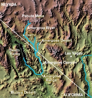
The Amargosa Valley is the valley through which the Amargosa River flows south, in Nye County, southwestern Nevada and Inyo County in the state of California. The south end is alternately called the "Amargosa River Valley'" or the "Tecopa Valley." Its northernmost point is around Beatty, Nevada and southernmost is Tecopa, California, where the Amargosa River enters into the Amargosa Canyon.
Indian Wells may refer to:

Garlock is an unincorporated community in Kern County, California. It is located 6.25 miles (10 km) east-southeast of Saltdale, at an elevation of 2169 feet.

Freeman Junction, a ghost town in Kern County, California, USA, was first homesteaded in the 1920s by Clare C. Miley, who was born in 1900. By the 1930s a restaurant, gas station and mining activities dominated the site. By June 1976 the town had died and the remains of the town have been removed by passersby.

Willow Springs is an unincorporated community in Kern County, California, United States. It is located 7.5 miles (12 km) west of Rosamond, at an elevation of 2,523 feet (769 m).

Lakeview Gusher Number One was an eruption of hydrocarbons from a pressurized oil well in the Midway-Sunset Oil Field in Kern County, California, in 1910. It created the largest accidental oil spill in history, lasting 18 months and releasing 9 million barrels of crude oil.

Havilah is an unincorporated community in Kern County, California. It is located in the mountains between Walker Basin and the Kern River Valley, 5 miles (8.0 km) south-southwest of Bodfish at an elevation of 3,136 feet (956 m).

This is a list of the National Register of Historic Places listings in Kern County, California.
Edward Meyer Kern was an American artist, topographer, and explorer of California, the Southwestern United States, and East Asia. He is the namesake of the Kern River and Kern County, California.
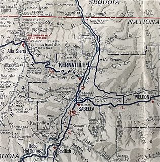
Kernville is a former settlement in the Kern River Valley of the Sierra Nevada, in Kern County, California.
The Keyesville massacre occurred on April 19, 1863, in Tulare County, now Kern County, California, during the Owens Valley Indian War. White settlers and a detachment of the 2nd California Volunteer Cavalry under Captain Moses A. McLaughlin, killed 35 Tübatulabal and Owens Valley Paiute men, "about ten miles from Keysville [sic], upon the right bank of Kern River".

Rancho Temescal was a farming outpost of Mission San Luis Rey de Francia, one of the 21 Franciscan missions established in California by Spain during the late 18th and early 19th centuries. The Mission was located on the coast where Oceanside, California is today. The Rancho was settled in 1819 by Leandro Serrano, and became the first non-native settlement within the boundaries of what would become Riverside County, California.

Sanford Lyon The Lyons Station Stagecoach Stop,, was a tavern and stagecoach stop near the southwest corner of Newhall Avenue and Sierra Highway, by Eternal Valley Cemetery. The site is located in the present day Newhall section of Santa Clarita, in Los Angeles County, California.

Saahatpa was a former Cahuilla settlement in Riverside County. It was a settlement of Juan Antonio's Mountain Cahuilla from 1851 to 1863. It was located in a valley that branched to the northeast from San Timoteo Canyon. The site is marked by California Historical Landmark #749, and is located at the abandoned Brookside Rest Area, on westbound Interstate 10, Freeway, 3 miles northwest of the I-10/CA 60 junction in modern Calimesa, California.

César E. Chávez National Monument, also known as Nuestra Señora Reina de la Paz, is a 116-acre (47 ha) U.S. National Monument in Keene, Kern County, California, located about 32 miles away from Bakersfield, California. The property was the headquarters of the United Farm Workers (UFW), and home to César Chávez from the early 1970s until his death in 1993. Chávez's gravesite is located in the property's gardens along with that of his wife, Helen Fabela Chávez. Originally developed as a headquarters and worker housing area for a quarry, it served as a tuberculosis sanitarium in the early 1900s, until its acquisition by the UFW in the early 1970s.

The Forty Acres, located in Delano, California, was the first headquarters of the United Farm Workers labor union. The union acquired the site of the compound in 1966, and the buildings were built in the ensuing years. The first building constructed on the property was a service station built in 1967, and several smaller service buildings were built soon afterward. The main building on the property, the Mission Revival styled Reuther Hall, was built from 1968 to 1969; the hall was named for United Auto Workers organizer Roy Reuther. A health care clinic and a retirement village were added to the property in the early 1970s.
The spring is now home to the Indian Wells Brewing Co. established in 1994 by founders Rick Lovett & Greg Antonaros. www.indianwellsbrewingco.com
