Sebastian Indian Reservation

Last updated
Sebastian Indian Reservation
(Tejon Indian Reservation)
SebastianIndianReservationrsHome 1899.jpg
Sebastian Indian Reservation home in 1899
Location Tehachapi Mountains,
Kern County,
California
Coordinates 34°56′29″N118°55′57″W / 34.9413°N 118.9325°W / 34.9413; -118.9325 Coordinates: 34°56′29″N118°55′57″W / 34.9413°N 118.9325°W / 34.9413; -118.9325
Built1853
Demolished1864
Official nameSebastian Indian Reservation
DesignatedJanuary 31, 1934
Reference no.133 [1]

The Sebastian Indian Reservation (1853-1864), more commonly known as the Tejon Indian Reservation, was formerly at the southwestern corner of the San Joaquin Valley in the Tehachapi Mountains, in southern central California.

Contents

It was located in the southwestern Tehachapis, from Tejon Creek and Tejon Canyon, west to Grapevine Canyon (Canada de las Uvas). [2]

History

Establishment

Edward F. Beale, the federal Superintendent of Indian Affairs for California, established this as the first Indian reservation in California in 1853. [2]

The 75,000 acre Tejon Reservation was within the private Rancho El Tejón Mexican land grant. However, Beale hoped if the land claims were upheld the land could be purchased by the federal government. To gain support for his efforts, Beale named the reservation after United States Senator William K. Sebastian of Arkansas, Chairman of the Indian Affairs Committee. [2] He supported Beale's plans to form a series of reservations, garrisoned by a military post, on government owned land.

The Indians were to support themselves by farming. However, throughout the reservation's existence, drought, insects, and crop disease undermined the attempts at farming. [2] The newly constructed Stockton – Los Angeles Road, replacing El Camino Viejo, skirted the western and northern sides of the reservation.

The reservation became operational in September 1853, and some California Indians moved in voluntarily. [3] Among the tribes of Mission Indians the reservation held, were 300 Emigdiano Chumash, whose homeland had included Tejon Canyon. In 1854, Lieutenant Beale reported that 2,500 Indians were living on the Sebastian Reservation.

In 1854, Fort Tejon was built 25 miles (40 km) to the southwest, to protect both the reservation's Indians and white settlers in the region from raids by the Paiutes, Chemeheui, Mohave peoples, and other Indian groups of the desert regions to the east. It was also to control the Indians who were living on the Tejon Reservation, and protect them from attacks by American immigrants and settlers. [2]

Operations

Farm equipment, cattle and sheep were brought to Tejon Reservation, and a staff of white employees hired to teach the Indians agriculture and supervise their activities. Hundreds of acres of land were plowed and planted with wheat, barley, and corn. Tejon Creek irrigated gardens, vineyards, and orchards. From the forest in upper Tejon Canyon Indians hauled timber from which they sawed the lumber needed at the reservation. Additionally there was wild game to hunt for in the Tehachapi Mountains and the San Joaquin Valley. [4] In that year the Indians gathered an abundant wheat harvest.

In early 1854, with political change in Washington, Beale's detractors charged him with embezzlement of government funds. Settlers in the San Joaquin Valley resented the agricultural competition from the Indians, and claimed that too much land had been set aside for them. He was removed from his office, but was exonerated of the charges.

Colonel Thomas J. Henley, was Beale's replacement as Superintendent of Indian Affairs for California. When Henley took charge, he noted only 800 Indians, with fewer than 350 present at one time, and only 1,500 acres under cultivation, indicating that numbers of Indians and amount of acreage under cultivation had been inflated by Beale. [2] Henley established other reservations in California, and appointed Colonel James R. Vineyard as the resident agent at the Sebastian Reservation.

In 1855, some of the reservation's Indian residents fled, and Vineyard requested assistance from Fort Tejon to find them and force their return. The fort's commander refused, stating their role was to protect the Indians and punish any that committed hostile acts, but not return Indians that voluntarily resided on the reservation. [5]

In 1856, rainfall was sparse but the harvest was enough for the 700 inhabitants that remained. A flour mill, granary, storehouse, and dwellings for the resident agent and the chiefs were built. A physician was also provided. In November 1856, the reservation was reduced to 25,000 acres. For 1856, the 700 Indians were reported as having 700 acres under cultivation. [2]

In 1857, drought continued, resulting in crop failure except were irrigation reached them and those grapevines and fruit trees that began to yield a harvest. The Indians were also encouraged to collect wild food during the winter. Despite that setback, new buildings were constructed and new arrivals increased the population to over 1,000.

A post office was established at the reservation in September 1858, but it was moved in 1859 to Sinks of Tejon Station, one of the stagecoach stations of the Butterfield Overland Mail. By 1858, nearly all of the remaining inhabitants were living in houses. Several families were raising livestock, and the women had learned to make American style clothing.

By 1859, Henley had been replaced as Superintendent of Indian Affairs for California. [2]

Finally, the winter of 1861—1862 was very wet causing Great Flood of 1862. It did break the 5-year drought, so the Reservation's Indians planted larger fields of grain, and there was a productive harvest during 1862. Additional Indians were encouraged to settle at the Sebastian Reservation, beyond the thirteen hundred that already lived there.

During the 1863 drought year, all the crops were lost except for 30 tons of hay. Settlers encroached on the Tejon Reservation's unsurveyed and unfenced land, with their cattle and sheep eating reservation crops. [2]

Demise

Meanwhile, by 1863 former agent Edward F. Beale had purchased five contiguous ranchos in the Tejon area, which included the Tejon Reservation land, and was raising 100,000 sheep. In 1863, he offered to lease 12,000 acres to the government, but withdrew the offer when he found that the government planned to move Owens Valley Paiute Indians there. He noted that he had made the offer only because Indians already on the reservation were his friends. [2]

In the summer of 1863, over 900 Owens Valley Paiute were marched through the Mojave Desert towards the Tejon Reservation, following their capitulation in the Owens Valley Indian War. They ended up in the Tule River Indian Reservation.

The reservation was ordered closed in June 1864. [2] Fort Tejon was also abandoned in 1864. [6]

Jose Pacheco, a Tejón leader, wrote to General Wright on April 16, 1864: [2]

"I should not have troubled you with this letter, Dear General, did I not think the agents here had wronged us. You and our great father at Washington do not know how bad we fare, or you would give us food or let us go back to our lands where we can get plenty of fish and game. I do not think we get the provisions intended for us by our Great Father; the agents keep it from us, and sell it to make themselves rich, while we and our children are very poor and hungry and naked."

On July 11, Austin Wiley wrote: [2] "I have the honor to inform you that all the Indians on the Tejon Farm and in the vicinity of Fort Tejon, some two hundred in number, have been removed from there to the Tule River farm." Wiley noted that there was no food for the Indians at Tejon.

Shortly thereafter, D. N. Cooley, Commissioner of Indian Affairs, summarized the reasons for the reservation's failure: [2]

"The lack of legal title to the land severely restrained investment in construction and development, leaving the reserve and the Indians on it in a state of constant uncertainty. The ideal of converting Indians from food gathering to settled agriculture was never realized."

California Historical Landmarks

NO. 133 SEBASTIAN INDIAN RESERVATION - The Sebastian or Tejón Indian Reservation (headquarters ten miles east of here) was established in 1853 by General Edward Fitzgerald Beale as one of several California reservations. The number of Indians quartered here varied from 500 to 2,000. General Beale acquired title to this area under Mexican land grant of 1843. In 1864 the U.S. government transferred the Indians to other reservations. [7]


The Rose Station California Historical Landmark reads:

NO. 300 Rose Station - From 1853 to 1875 this site, originally a vaquero camp of the Sebastian Indian Reservation, was known as Rancho Canoa (trough). In 1875, Wm. B. Rose built an adobe stage station on the site of the Overland Mail way station established 1858. Rose Station was a stockmen's headquarters, post office, and polling place. [8]

Both markers are located at Grapevine Road and 'D' Street 70 miles south of Mettler, California.

See also

Related Research Articles

Tehachapi Mountains

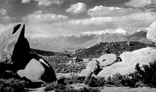
The Tehachapi Mountains are a mountain range in the Transverse Ranges system of California in the Western United States. The range extends for approximately 40 miles (64 km) in southern Kern County and northwestern Los Angeles County.

Tejon Pass

The Tejon Pass, previously known as Portezuelo de Cortes, Portezuela de Castac, and Fort Tejon Pass, is a mountain pass between the southwest end of the Tehachapi Mountains and northeastern San Emigdio Mountains, linking Southern California north to the Central Valley. It has been traversed by major roads such as the El Camino Viejo, the Stockton – Los Angeles Road, the Ridge Route, U.S. Route 99, and now Interstate 5.

Fort Tejon United States historic place

Fort Tejon in California is a former United States Army outpost which was intermittently active from June 24, 1854, until September 11, 1864. It is located in the Grapevine Canyon between the San Emigdio Mountains and Tehachapi Mountains. It is in the area of Tejon Pass along Interstate 5 in Kern County, California, the main route through the mountain ranges separating the Central Valley from the Los Angeles Basin and Southern California. The fort's location protected the San Joaquin Valley from the south and west.

Tejon Ranch Land owner in California, USA

Tejon Ranch Company, based in Lebec, California, is one of the largest private landowners in California. The company was incorporated in 1936 to organize the ownership of a large tract of land that was consolidated from four Mexican land grants acquired in the 1850s and 1860s by ranch founder General Edward Fitzgerald Beale.

Kawaiisu

The Kawaiisu are a Native Californian ethnic group in the United States, which lives in the Tehachapi Valley and across the Tehachapi Pass in the southern Sierra Nevada Mountains to the north, toward Lake Isabella and Walker Pass. Historically, the Kawaiisu also traveled eastward on food-gathering trips to areas in the northern Mojave Desert, to the north and northeast of the Antelope Valley, Searles Valley, as far east as the Panamint Valley, the Panamint Mountains, and the western edge of Death Valley. Today, some Kawaiisu people are enrolled in the Tule River Indian Tribe.

Elizabeth Lake (Los Angeles County, California)

Elizabeth Lake is a natural lake that lies directly on the San Andreas Fault in the northern Sierra Pelona Mountains, in northwestern Los Angeles County, southern California.

Rancho La Liebre was a 48,800-acre (197 km2) Mexican land grant in present-day Kern County, California and Los Angeles County, given in 1846 by Governor Pío Pico to José María Flores. Liebre means "Hare" in Spanish and the rancho was named as such because of the abundance of jack rabbits in the area.

Rancho El Tejón was a 97,617-acre (395.04 km2) Mexican land grant in the Tehachapi Mountains and northeastern San Emigdio Mountains, in present day Kern County, California. It was granted in 1843 by Governor Manuel Micheltorena to José Antonio Aguirre and Ygnacio del Valle.

Rancho Castac or Rancho Castec was a 22,178-acre (89.75 km2) Mexican land grant in present-day Kern and Los Angeles counties, California, made by Governor Manuel Micheltorena to Jose Maria Covarrubias in 1843. The rancho in the Tehachapi Mountains lay between Castac Lake on the south and the present Grapevine on the north and included what is now the community of Lebec. The rancho is now a part of the Tejon Ranch.

Tule River Indian Tribe of the Tule River Reservation

The Tule River Indian Tribe of the Tule River Reservation is a federally recognized tribe of Native Americans. The Tule River Reservation is the name of the tribe's reservation, which is located in Tulare County, California. The reservation was made up of Yokuts, about 200 Yowlumne, Wukchumnis, and Western Mono and Tübatulabal. Tribal enrollment today is approximately 1,857 with 1,033 living on the Reservation.

The Owens Valley War was fought between 1862 and 1863, by California Volunteers and local settlers against the Owens Valley Paiutes, and their Shoshone and Kawaiisu allies, in the Owens Valley of California and the southwestern Nevada border region. The removal of a large number of the Owens River Native Californians to Fort Tejon in 1863, was considered the end of the war. Minor hostilities continued occasionally until 1867.

The Stockton–Los Angeles Road, also known as the Millerton Road, Stockton–Mariposa Road, Stockton–Fort Miller Road or the Stockton–Visalia Road, was established about 1853 following the discovery of gold on the Kern River in Old Tulare County. This route between Stockton and Los Angeles followed by the Stockton–Los Angeles Road is described in "ITINERARY XXI. From Fort Yuma to Benicia, California", in The Prairie Traveler: A Hand-book for Overland Expeditions by Randolph Barnes Marcy. The Itinerary was derived from the report of Lieutenant R. S. Williamson on his topographical survey party in 1853, that was in search of a railroad route through the interior of California.

Tejon Creek, originally in Spanish Arroyo de Tejon, is a stream in Kern County, California. Its headwaters are located on the western slopes of the Tehachapi Mountains, and it flows northwest into the southern San Joaquin Valley.

Old Tejon Pass Mountain pass in the Tehachapi Mountains

The Old Tejon Pass is a mountain pass in the Tehachapi Mountains linking Southern and Central California.

Willow Springs Canyon

Willow Springs Canyon is a canyon cut by Willow Springs Canyon Wash. Its source is at the head of the canyon in the gap in the Portal Ridge of the Transverse Range, 0.5 miles north of Elizabeth Lake. It is cut into the slope to the northeast into the Antelope Valley, crossing the California Aqueduct. The mouth of the Canyon is 0.25 miles southwest of its confluence with Myrick Canyon Wash which is 300 feet southwest of the intersection of Munz Ranch Road with the Neenach - Fairmont Road in Los Angeles County, California, USA.

The Tejon Indian Tribe of California is a federally recognized tribe of Kitanemuk, Yokuts, and Chumash indigenous people of California.

The California Indian Wars were a series of massacres, wars, and battles between the United States Army, and the Indigenous peoples of California. The wars lasted from 1850, immediately after Alta California, acquired during the Mexican–American War, became the state of California, to 1880 when the last minor military operation on the Colorado River ended the Calloway Affair of 1880.
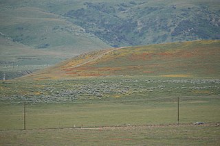
Castac Lake

Castac Lake is a natural saline endorheic lake near Lebec, California. The lake is located in the Tehachapi Mountains just south of the Grapevine section of Interstate 5, and within Tejon Ranch. Normal water elevations are 3,482 feet (1,061 m) above sea level.

The Tule River War of 1856 was a conflict where American settlers, and later, California State Militia, and a detachment of the U. S. Army from Fort Miller, fought a six-week war against the Yokut in the southern San Joaquin Valley.

Between 1851 and 1892, the United States Army forced California's tribes to sign 18 treaties that relinquished each tribe's rights to their traditional lands in exchange for reservations. Due to pressure from California representatives, Congress failed to ratify the treaties and ordered them to remain secret. In 1896 the Bureau of American Ethnology report on major native American Indian interactions with the United States Government was the first time the treaties were made public. The report, compiled By Charles C. Royce, includes the 18 lost treaties between the state's tribes and a map of the reservations. Below is the California segment of the report listing the treaties. The full report covered all 48 states' tribal interactions nationwide with the U.S. government.
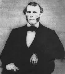
References

  1. "Sebastian Indian Reservation". Office of Historic Preservation, California State Parks. Retrieved 2012-10-07.
  2. 1 2 3 4 5 6 7 8 9 10 11 12 13 14 NPS: Tejon Reservation
  3. Barras, Judy (1984). Their Places Shall Know Them No More. Bakersfield, California: Sierra Printers. p. 65.
  4. Boyd, William H. (1972). A California middle border, the Kern River Country, 1772-1880. Richardson Texas: The Havilah Press. p. 21.
  5. Boyd, 1972, p. 28.
  6. Boyd, 1972. p. 19-26.
  7. californiahistoricallandmarks.com Landmark chl-133
  8. californiahistoricallandmarks.com Landmark chl-300