The Los Gatos Creek Trail is a 9.7-mile (15.6 km) pedestrian and bicycle trail that runs through western Santa Clara County in California, from Lexington Reservoir in Los Gatos, California through Campbell, California to Meridian Avenue in San Jose, California alongside Los Gatos Creek. The trail is heavily used.
The San Diego Creek bicycle path is the major bicycle backbone of the city of Irvine, California, which largely contains it. It connects major points such as Newport Beach, University of California, Irvine, Boomers, Colonel Bill Barber Park, Irvine Civic Center, The Crossroads Shopping Center, Woodbridge High School, Woodbridge Community Park, Atria Senior Residential Area, Windrow Community Park, Irvine Medical Complex, and ultimately, Irvine Spectrum Center. It also runs through the majority of Irvine's neighborhoods such as Westpark, Woodbridge, and Oak Creek. The path begins where the San Diego Creek empties into Upper Newport Bay. The Bay itself makes for a pleasant ride with a Class 2 bike lane on the Eastern shore along a quiet road, some busy streets in the South and a section of Class 1 path to the East.

Bakersfield station is a train station in Bakersfield, California. It is the southern terminus of Amtrak California's San Joaquin route, with Amtrak Thruway Motorcoach service continuing to Amtrak stations and bus stops throughout Southern California and Nevada. The station opened with a celebration on July 4, 2000. It contains an 8,300 square feet (770 m2) station, 2 tracks, and a 15-bay bus station.
Hackensack RiverWalk a is partially constructed greenway along the Newark Bay and Hackensack River on the west side of the Bergen Neck peninsula in Hudson County, New Jersey. The eight-mile walkway, following the contour of the water's edge, will run between the southern tip at Bergen Point, where it may connect to the Hudson River Waterfront Walkway, and Eastern Brackish Marsh in the north. Existing parks and promenades have been incorporated and some new sections have been built, but there remain large gaps. There is a RiverWalk in the city of Hackensack, sometimes called the Hackensack RiverWalk, but they are not part of the same project nor are they connected. A parallel walkway on the west banks of the river is known as the Meadow Path.

Jastro Park is a public park located in Bakersfield, California. It was constructed on two square blocks of land at the corner of Truxtun Ave. and Elm St, in Westchester.
Kern River County Park is a large recreation facility located just north of Bakersfield, California. The facility is 1,012 acres (4.10 km2), and includes a park, zoo, golf course, and other amenities. The complex is served by Alfred Harrell Highway. The segment to the west of the park was built as a 4-lane local freeway. The segment to the east of the park was built as a 2-lane expressway, with land reserved for a future 4-lane freeway.

The Kern Veterans Memorial is a monument located in Kern County, California. It honors all Kern County residents who served in the armed forces, both in peacetime and in war. It is located in downtown Bakersfield, at the corner of Truxtun Ave. and S St. The memorial is adjacent to the Kern County Visitors Bureau, Bakersfield Amtrak Station, and Beale Memorial Library. It is also in between the two segments of Mill Creek.

Kern County’s transportation system was quoted as the “unseen industry.” Located at the southern end of the San Joaquin Valley, the county is at a prime location to ship goods west to the central coast, south to ports in Los Angeles, and east to corridors that connect to the rest of the country. It is also on major corridors that link to all northern points.

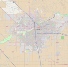
Downtown is the central business district for Bakersfield, California. Located in the heart of the city, Downtown Bakersfield is easily accessible from all its other parts. It is also reemerging as the center of Bakersfield's arts, culture and entertainment sectors. Downtown contains several of the cities major theaters, sporting complexes, museums, and historical landmarks.

Beale Memorial Clock Tower is a clock tower located in Bakersfield, California. It was a gift to the city; built by Truxtun Beale in memory of his mother, Mary Edwards Beale. It was dedicated on April 4, 1904, and was built in the middle of the intersection of 17th St. and Chester Ave. When he was ambassador to Spain, Beale was inspired by a clock tower he saw there. He hired architect Clinton Day to design it.
Southwest Bakersfield is the southwest region of Bakersfield, California. It is roughly bounded by the Kern River to the north and Oak Street/Wible Road to the east. The other boundaries are the city limits themselves.
Northeast Bakersfield is the northeast region of Bakersfield, California. Starting south and traveling clockwise, it is roughly bounded by Edison Rd., Mt. Vernon Ave., the Kern River, and Alfred Harrell Hwy./Comanche Rd. Other boundaries are the city limits.
The Kern River Parkway is primarily a natural preserve in Bakersfield, California. It runs the length of the Kern River from the mouth of the Kern Canyon to Interstate 5. At 6,000 acres, it is the largest municipal park in the county. The parkway was created in 1976 when the city purchased all assets related to the Kern River from Tenneco West.
The Department of Recreation and Parks is a department of the city of Bakersfield, California. It is responsible for the maintenance of the city's lands which include: parks, natural preserves, and streetscapes. It also runs recreational programs throughout the year at various locations throughout the city. The department also runs the Bakersfield Ice Sports Center and McMurtrey Aquatic Center. Although there are incorporated areas in the northwest, the city does not have any parks in that region. They are instead maintained by the North of the River Recreation and Parks District. The department has been accredited by the Commission for Accreditation of Park and Recreation Agencies.
Gordon's Ferry is both a geographical location and a historic site in Bakersfield, California. It is located where China Grade Loop crosses the Kern River and meets with Alfred Harrell Highway in Northeast Bakersfield. It is named after a ferry that used to cross the river near the existing bridge. It was one of the only eastern crossings, until 1877, when the Jewett Avenue bridge was constructed farther west. It is California Historical Landmark #137.
The West 19th Street Line was a line of the Bakersfield and Kern Electric Railway. The route originated at the intersection of 19th Street and F Street, and traveled west on 19th Street. It would turn south on Oak Street and terminate at Truxtun Avenue. For most of its life, the line was combined with the North Chester Line. The line was constructed in 1903, as part of the original expansion plan. It closed in 1933.
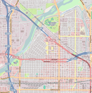
Mill Creek is a district in Downtown Bakersfield, California. It is primarily a mixture of residential and commercial on the east side of downtown. Since the mid-2000s, the district has gone through major redevelopment. These included, the development of the Kern Island Canal into a walking path, the redevelopment of Central Park, construction of the Federal Courthouse, and construction of several new housing and commercial developments.
Kern Island Canal is an irrigation canal in Kern County, California. It primarily irrigates farmland located on the Kern Lakebed, south of Bakersfield. It originates from a common diversion at Manor Street in Bakersfield, which also supplies the Carrier Canal and Eastside Canal. The common diversion originates from the Kern River about 1 mile (1.6 km) south of Gordon's Ferry.
Hart Memorial Park is a large public park in Kern County, California. It is located just north of Bakersfield. The park is 370 acres (150 ha), and contains two lakes and three canals. It was named after County Supervisor John Hart, who spearheaded the project. Constructed between 1921 and 1936, it is the oldest section of the Kern River County Park.

Bakersfield is a proposed California High-Speed Rail station in Bakersfield, California. The station is part of the Initial Construction Segment expected to be completed by 2017.