
The Barton Creek Greenbelt located in Austin, Texas is managed by the City of Austin's Park and Recreation Department. The Greenbelt is a 7.25-mile (11.67 km) stretch of public land that begins at Zilker Park and stretches South/Southwest to the final section commonly referred to as "The Hill of Life" which ends in the Woods of Westlake subdivision. The Barton Creek Greenbelt consists of three areas: the Lower Greenbelt, the Upper Greenbelt, and the Barton Creek Wilderness Park and is characterized by large limestone cliffs, dense foliage, and shallow bodies of water.

Golden Empire Transit is the operator of mass transportation in Bakersfield, California. There are 16 routes serving Greater Bakersfield, which includes both the City of Bakersfield and adjacent unincorporated communities. It, however, does not serve Rio Bravo, which is too rural for urban bus service though it is part of the city. Since 2005, the entire bus fleet is powered by compressed natural gas.
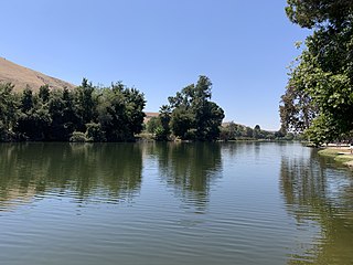
The Park at River Walk is a public park located in Bakersfield, California. The park is 32 acres (130,000 m2), and contains two lakes connected by a stream. It is also the location of the Spectrum Amphitheater, one of two large outdoor theaters in Bakersfield. The park is located next to the Kern River Bike Trail. It is also located near the Calloway Drive Interchange for the Westside Parkway.
Mill Creek is a linear park located in Bakersfield, California. It runs along the Kern Island Canal between Golden State Avenue and California Avenue in downtown, although there is a gap between 19th Street and the BNSF railroad yard. The center of the park is Central Park, the only park in downtown. The park contains a lake with spray fountains and the “Mill Creek” bridge. It is also home to the Bakersfield Museum of Art and the Bakersfield Community House.
Beale Park is a public park located in Bakersfield, California. It is Bakersfield’s first park, located on Oleander St.
Jastro Park is a public park located in Bakersfield, California. It was constructed on two square blocks of land at the corner of Truxtun Ave. and Elm St, in Westchester.
The California Living Museum is a zoo in Bakersfield, California. The primary focuses are plants and animals that are native to California, specifically Kern County.

Kern River County Park is a large recreation facility located just north of Bakersfield, California. The facility is 1,012 acres (4.10 km2), and includes a park, zoo, golf course, and other amenities. The complex is served by Alfred Harrell Highway. The segment to the west of the park was built as a 4-lane local freeway. The segment to the east of the park was built as a 2-lane expressway, with land reserved for a future 4-lane freeway.

Kern County’s transportation system was quoted as the “unseen industry.” Located at the southern end of the San Joaquin Valley, the county is at a prime location to ship goods west to the central coast, south to ports in Los Angeles, and east to corridors that connect to the rest of the country. It is also on major corridors that link to all northern points.

Downtown is the central business district for Bakersfield, California. It contains several of the cities major theaters, sporting complexes, museums, and historical landmarks.
Southwest Bakersfield is the southwest region of Bakersfield, California. It is roughly bounded by the Kern River to the north and Oak Street/Wible Road to the east. The other boundaries are the city limits themselves.
Northeast Bakersfield is the northeast region of Bakersfield, California. It is roughly bounded by Panorama Drive and the Kern River to the north, Alfred Harrell Highway/Comanche Drive to the east, Edison Highway to the south, and Union Avenue to the west. The region of East Bakersfield is located within these boundaries but is usually not considered part of the Northeast. Instead, the Northeast wraps around the boundaries of East Bakersfield. Other boundaries are the city limits.

The Kern County Library is a public library system serving the residents of Kern County, California. The library system is headquartered at the Beale Memorial Library in Downtown Bakersfield. There are additional branches located throughout Kern County. The library is also a part of the San Joaquin Valley Library System (SLVLS), which is a corporative network of library systems located throughout the San Joaquin Valley.
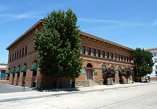
The Tevis Block, also known as the Kern County Land Company Building, is a historic office building in Bakersfield, California. The structure was placed on the National Register of Historic Places (NRHP) on March 29, 1984.
The Bakersfield Department of Water Resources is a municipal utility in Bakersfield, California. Primarily it manages the city's water rights to the Kern River. Water is sent to water retailers that the city has contracts with, and recharge basins to seep into the groundwater table. The department also manages water distributions to most of Southwest Bakersfield and a small part of Northwest Bakersfield.
The Kern River Parkway is primarily a natural preserve in Bakersfield, California. It runs the length of the Kern River from the mouth of the Kern Canyon to Interstate 5. At 6,000 acres, it is the largest municipal park in the county. The parkway was created in 1976 when the city purchased all assets related to the Kern River from Tenneco West.
Beach Park is a public park in Bakersfield, California. It is located at the major intersection of 24th street and Oak street, which makes it one of the more visible parks in the city. It is directly adjacent to the Kern River Parkway, and is used as a staging area for the various trails in the parkway.
Bakersfield provides a wide variety of arts and culture.
The Bakersfield Department of Public Works is a department of city of Bakersfield, California. It is responsible for a variety of city functions including: road maintenance and construction, waste water and sewer treatment, and vehicle maintenance. It is headquartered in City Hall South.
Hart Memorial Park is a large public park in Kern County, California. It is located just north of Bakersfield. The park is 370 acres (150 ha), and contains two lakes and three canals. It was named after County Supervisor John Hart, who spearheaded the project. Constructed between 1921 and 1936, it is the oldest section of the Kern River County Park.
