Florence-Graham is a census-designated place in Los Angeles County, California. The population was 61,983 at the 2020 census, down from 63,387 at the 2010 census. The census area includes separate communities of Florence, Firestone Park, and Graham. It is located in the south central region of Los Angeles County. The neighboring communities are Central-Alameda, Florence, Green Meadows, Lynwood, South Gate, South Park, Vernon, Walnut Park and Watts.

The Sepulveda Dam is a project of the U.S. Army Corps of Engineers designed to withhold winter flood waters along the Los Angeles River. Completed in 1941, at a cost of $6,650,561, it is located south of center in the San Fernando Valley, approximately eight miles east of the river's source in the western end of the Valley, in Los Angeles, California.
The Albany Parks & Recreation is a city agency in AlbanyAlbany, Oregon, United States responsible for maintaining the local city parks as well as organizing cultural events. Its headquarters are at City Hall, 333 Broadalbin Street SW. One goal of the City of Albany is to have all residents live within 2 miles (3 km) of a park.

The Greater Grand Forks Greenway is a huge greenway bordering the Red River and Red Lake River in the twin cities of Grand Forks, North Dakota and East Grand Forks, Minnesota. At 2,200 acres (9 km2), the Greenway is more than twice the size of New York City's Central Park. It has an extensive, 20-mile (32 km) system of bike paths, which are used by bikers, walkers, joggers, and rollerbladers. In 2007, the system was designated as a National Recreation Trail by the National Park Service.

Saratoga Spa State Park is a 2,379-acre (9.63 km2) state park located in Saratoga County, New York in the United States. The park is in the City of Saratoga Springs, near US 9 and NY 50.

Chief Logan State Park is located on 3,988 acres (1,614 ha) about 4 miles (6.4 km) north of Logan in Logan County, West Virginia, United States. The park, the town and the county were all named after Chief Logan, a Mingo Native American leader who lived in the region before the American Revolutionary War. Each summer the Liz Spurlock Amphitheater at Chief Logan State Park is the site for outdoor dramas, including the historical drama "The Aracoma Story" about Shawnee tribal members who lived at the present-day location of the town of Logan. The outdoor drama theater produces the Aracoma story and two to three other plays or musicals every year.

Huntington is home to eleven parks located in the neighborhoods of Huntington. An amusement park is also adjacent to the city.

Murray City Park is a public urban park located in and operated by the city of Murray, Utah, USA.
The Park at River Walk is a public park located in Bakersfield, California. The park is 32 acres (130,000 m2), and contains two lakes connected by a stream. It is also the location of the Spectrum Amphitheater, one of two large outdoor theaters in Bakersfield. The park is located next to the Kern River Bike Trail. It is also located near the Calloway Drive Interchange for the Westside Parkway.
Jastro Park is a public park located in Bakersfield, California. It was constructed on two square blocks of land at the corner of Truxtun Ave. and Elm St, in Westchester.

Kern River County Park is a large recreation facility located just north of Bakersfield, California. The facility is 1,012 acres (4.10 km2), and includes a park, zoo, golf course, and other amenities. The complex is served by Alfred Harrell Highway. The segment to the west of the park was built as a 4-lane local freeway. The segment to the east of the park was built as a 2-lane expressway, with land reserved for a future 4-lane freeway.

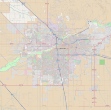
Downtown is the central business district for Bakersfield, California. It contains several of the city's major theaters, sports complex, museums, and historical landmarks.
Patton Park is a 93-acre (38 ha) park located on the southwest side of Detroit, Michigan. The park, named for the World War II US military leader General George S. Patton, was dedicated in the early 1950s. Local landowner Jacques Baby bequeathed the 93-acre (38 ha) tract of land to the City of Detroit for a park. The park retains a restrictive covenant that prohibits the City from tampering with the park, lest the park returns to Baby's descendants.
Jefferson Park is a public park located in Bakersfield, California.
Beach Park is a public park in Bakersfield, California. It is located at the major intersection of 24th street and Oak street, which makes it one of the more visible parks in the city. It is directly adjacent to the Kern River Parkway, and is used as a staging area for the various trails in the parkway.
The Department of Recreation and Parks is a department of the city of Bakersfield, California. It is responsible for the maintenance of the city's lands which include: parks, natural preserves, and streetscapes. It also runs recreational programs throughout the year at various locations throughout the city. The department also runs the Bakersfield Ice Sports Center and McMurtrey Aquatic Center. Although there are incorporated areas in the northwest, the city does not have any parks in that region. They are instead maintained by the North of the River Recreation and Parks District. The department has been accredited by the Commission for Accreditation of Park and Recreation Agencies.
Bakersfield provides a wide variety of arts and culture.
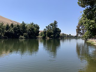
Hart Memorial Park is a large public park in Kern County, California. It is located just north of Bakersfield. The park is 370 acres (150 ha), and contains two lakes and three canals. It was named after County Supervisor John Hart, who spearheaded the project. Constructed between 1921 and 1936, it is the oldest section of the Kern River County Park.
Patriots Park is a public park in Bakersfield, California. It is constructed on 20 acres (8.1 ha) at the corner of Ming Ave and New Stine Rd, although the park wraps around an apartment complex at the exact corner.