
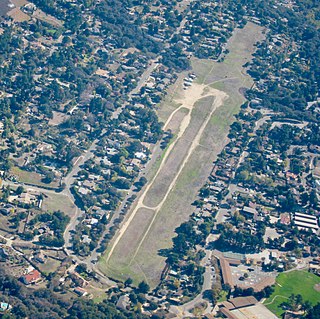
Santa Cruz, California, United States once had several active public airports, of which all but one have closed.
Santa Cruz, California, United States once had several active public airports, of which all but one have closed.

Santa Cruz County, officially the County of Santa Cruz, is a county on the Pacific coast of the U.S. state of California. As of the 2020 census, the population was 270,861. The county seat is Santa Cruz. Santa Cruz County comprises the Santa Cruz–Watsonville, CA Metropolitan Statistical Area, which is also included in the San Jose–San Francisco–Oakland, CA Combined Statistical Area. The county is on the California Central Coast, south of the San Francisco Bay Area region. The county forms the northern coast of the Monterey Bay, with Monterey County forming the southern coast.

Watsonville Municipal Airport is three miles (5 km) northwest of Watsonville, in Santa Cruz County, California, United States. The airport covers 330 acres (134 ha) and has two runways. The largest aircraft to ever land at Watsonville were 05-5141 and 05-5143, C-17 Globemaster IIIs from March ARB, California.
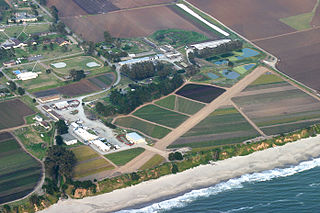
Monterey Bay Academy Airport is a small daytime only airfield located near the city of Watsonville in Santa Cruz County, California, United States. This private-use airport is owned by the Seventh-day Adventist Church and is located on the campus of Monterey Bay Academy, previously the military installation Camp McQuaide. The grass airfield is currently managed by AirSpace Integration. Prior permission for use is required from the airport owner.
Santa Maria Public Airport is three miles (5 km) south of Santa Maria, in northern Santa Barbara County, California, United States.
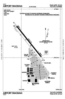
Palo Alto Airport is a general aviation airport in the city of Palo Alto in Santa Clara County, California, United States, near the south end of San Francisco Bay on the western shore.

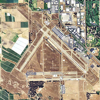
Reid–Hillview Airport of Santa Clara County is in the eastern part of San Jose, in Santa Clara County, California, United States. It is owned by Santa Clara County and is near the Evergreen district of San Jose where aviation pioneer John J. Montgomery experimented with gliders in 1911. Reid–Hillview Airport was also the official general aviation airport for the 2015 Super Bowl in Levi's Stadium.

Area code 831 is a telephone area code in the North American Numbering Plan (NANP) for a small region of the U.S. state of California. The numbering plan area (NPA) comprises Monterey County, San Benito County, and Santa Cruz County. The area code was created on July 11, 1998 in a split from area code 408.

Santa Cruz Metropolitan Transit District (SCMTD), or simply Santa Cruz METRO, provides bus service throughout Santa Cruz County, California.

Napa County Airport is a public airport five miles (8 km) south of Napa, in Napa County, California, United States. It has three runways.
Lost Hills Airport, also known as Lost Hills-Kern County Airport, was a public airport located one mile (1.6 km) northeast of the central business district (CBD) of Lost Hills, in Kern County, California, United States. It was mostly used for general aviation. It was closed in March 2019.

Watsonville Airport was an airport in Watsonville, California, United States. It was used during World War II for antisubmarine blimps in the defense of California. Opened in 1930 by Watsonville Airport Incorporated, it was the city's first airport. Watsonville Airport Incorporated sold five thousand shares of stock to purchase 85 acres of land southwest of the city. The airport was built at California State Route 1 and Salinas road in Monterey County. The airport has three 2,300 feet dirt runways in a triangle shape. In 1930 Watsonville Airport Incorporated's first president was Harlow Ford, and Claude Wilson was the first airport manager and flight instructor.
Marlboro County Jetport, also known as H.E. Avent Field, is a county-owned public-use airport located 3 nautical miles west of the central business district of Bennettsville, in Marlboro County, South Carolina, United States.

El Reno Regional Airport is in Canadian County, Oklahoma, United States, five miles southwest of El Reno, which owns it. The FAA's National Plan of Integrated Airport Systems for 2009–2013 categorized it as a general aviation facility.

Eagle Field is a privately owned, private use airport in Fresno County, California, United States. It is located seven nautical miles southwest of the central business district of Dos Palos, a city in neighboring Merced County.

W. R. Byron Airport is a privately owned, private use airport in Riverside County, California, United States. It is located four nautical miles northwest of the central business district of Blythe, California, within the city limits.
Flying S Ranch Airport is a private airport located approximately 10 miles (16 km) northeast of Caliente, California.
Camp McQuaide is a former United States Army camp located near the city of Watsonville in Santa Cruz County, California, USA. After it was closed, it redeveloped into the Monterey Bay Academy and the airfield was reopened as the Monterey Bay Academy Airport.
Carmel Valley Airfield was a privately owned Airpark in Carmel Valley, California from 1941 to 2002. The airport was later called the Carmel Valley Vintage Airfield. The California Historical Resources Commission voted to nominate the "Carmel Valley Vintage Airpark" (CVVA) as a State Historic Resource. The Commission found that development of the airport was important as it represented the "first airpark in the United States and in the world."
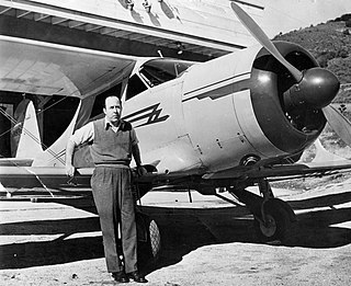
Tirey Lafayette Ford Jr. was an American businessman, aircraft pilot, vice president of Swayne & Hoyt steamship company, co-developed the Carmel Valley Airfield, Carmel Valley Village, and started the Insul-8 Corporation, which exists today as Conductix-Wampfler. His career in manufacturing, shipping, and aviation stretched more than fifty years.
This article needs additional citations for verification .(September 2014) |