
The Dwight D. Eisenhower National System of Interstate and Defense Highways, commonly known as the Interstate Highway System, or the Eisenhower Interstate System, is a network of controlled-access highways that forms part of the National Highway System in the United States. The system extends throughout the contiguous United States and has routes in Hawaii, Alaska, and Puerto Rico.
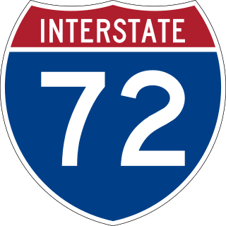
Interstate 72 (I-72) is an Interstate Highway in the midwestern United States. Its western terminus is in Hannibal, Missouri, at an intersection with U.S. Route 61 (US 61); its eastern terminus is at Country Fair Drive in Champaign, Illinois. The route runs through the major cities of Decatur, Illinois, and Springfield, Illinois. In 2006, the Illinois General Assembly dedicated all of I-72 as Purple Heart Memorial Highway. The stretch between Springfield and Decatur is also called Penny Severns Memorial Expressway, and the section between mile 35 and the Mississippi River is known as the Free Frank McWorter Historic Highway.

DeKalb is a city in DeKalb County, Illinois, United States. The population was 40,290 at the 2020 census. The city is named after decorated Franconian-French war hero Johann de Kalb, who died during the American Revolutionary War.

State Route 120 is a state highway in the central part of California, connecting the San Joaquin Valley with the Sierra Nevada, Yosemite National Park, and the Mono Lake area. Its western terminus is at Interstate 5 in Lathrop, and its eastern terminus is at U.S. Route 6 in Benton. While the route is signed as a contiguous route through Yosemite, the portion inside the park is federally maintained and is not included in the state route logs. The portion at Tioga Pass at Yosemite's eastern boundary is the highest paved through road in the California State Route system. This part is not maintained in the winter and is usually closed during the winter season.
A routenumber, designation or abbreviation is an identifying numeric designation assigned by a highway authority to a particular stretch of roadway to distinguish it from other routes and, in many cases, also to indicate its classification, general geographical location and/or orientation. The numbers chosen may be used solely for internal administrative purposes; however, in most cases they are also displayed on roadside signage and indicated on maps.

The Manual on Uniform Traffic Control Devices for Streets and Highways is a document issued by the Federal Highway Administration (FHWA) of the United States Department of Transportation (USDOT) to specify the standards by which traffic signs, road surface markings, and signals are designed, installed, and used. In the United States, all traffic control devices must legally conform to these standards. The manual is used by state and local agencies as well as private construction firms to ensure that the traffic control devices they use conform to the national standard. While some state agencies have developed their own sets of standards, including their own MUTCDs, these must substantially conform to the federal MUTCD.
The U.S. Route shield is the highway marker used for United States Numbered Highways. Since the first U.S. Route signs were installed in 1926, the general idea has remained the same, but many changes have been made in the details. Originally, the shield included the name of the state in which the sign was erected and the letters "U S" on a shield-shaped sign. Over time, the shield has been simplified to consist of a white shield outline on a black square background, containing only a black route number. However, because each state is responsible for the production and maintenance of U.S. Route shields, several variants of the shield have existed over the years.

Interstate 88 (I-88) is an Interstate Highway in the US state of Illinois that runs from an interchange with I-80 near Silvis and Moline to an interchange with I-290 and I-294 in Hillside, near Chicago. I-88 is 140.60 miles (226.27 km) long. This route is not contiguous with I-88 in New York. Since 2010, most of I-88 has been part of the Chicago–Kansas City Expressway. The highway also runs through the cities of Aurora, Naperville, DeKalb, and Dixon. East of Rock Falls, the route is a part of the Illinois Tollway system.

State Route 259 (SR 259) is an approximately 1.48-mile (2.38 km) state highway in the U.S. state of California, serving as a freeway connector between I-215 and SR 210 in San Bernardino. It has one complete interchange and one partial interchange.

A county highway is a road in the United States and in the Canadian province of Ontario that is designated and/or maintained by the county highway department. Route numbering can be determined by each county alone, by mutual agreement among counties, or by a statewide pattern.

An Illinois Tollway oasis is a type of commercialized rest area sited over Interstate Highways that are part of the Illinois Tollway system in northern Illinois, United States. The four oases offer food and gasoline vendors and are found in the Chicago Metropolitan Area, DeKalb, and Belvidere. Although the oases date back to the original tollway construction in 1958, they were redeveloped in 2003–2005 by Wilton Partners, a private developer. The redevelopment of the oases has been the focal point of alleged political corruption. The four oases are administered by a court-appointed manager following default of Wilton Partners.
A highway shield or route marker is a sign denoting the route number of a highway, usually in the form of a symbolic shape with the route number enclosed. As the focus of the sign, the route number is usually the sign's largest element, with other items on the sign rendered in smaller sizes or contrasting colors. Highway shields are used by travellers, commuters, and all levels of government for identifying, navigating, and organising routes within a given jurisdiction. Simplified highway shields often appear on maps.

The primary highway system makes up over 9,000 miles (14,000 km), approximately 8 percent of the U.S. state of Iowa's public road system. The Iowa Department of Transportation is responsible for the day-to-day maintenance of the primary highway system, which consists of Interstate Highways, United States Highways, and Iowa state highways. Currently, the longest primary highway is U.S. Highway 30 at 332 miles (534 km). The shortest highway is Interstate 129 at 0.27 miles (430 m).
Highways are split into at least four different types of systems in the United States: Interstate Highways, U.S. Highways, state highways, and county highways. Highways are generally organized by a route number or letter. These designations are generally displayed along the route by means of a highway shield. Each system has its own unique shield design that will allow quick identification to which system the route belongs.

The Delaware State Route System consists of roads in the U.S. state of Delaware that are maintained by the Delaware Department of Transportation (DelDOT). The system includes the portions of the Interstate Highway System and United States Numbered Highways system located in the state along with state routes and other roads maintained by DelDOT. All roads maintained by the state are assigned a maintenance road number that is only marked on little white markers at intersections and on auxiliary plates below warning signs approaching intersections. These numbers are only unique in a specific county; some roads can be designated with multiple road numbers, and numbers do not necessarily correspond to the signed Interstate, U.S., or state route numbers. DelDOT maintains a total of 5,386.14 miles (8,668.15 km) of roads, comprising 89 percent of the roads within the state. Some large bridges in the state are maintained by other agencies including the U.S. Army Corps of Engineers and the Delaware River and Bay Authority. Roads in the system include multilane freeways, multilane surface divided highways, and two-lane undivided roads serving urban, suburban, and rural areas. Some of the roads maintained by DelDOT are toll roads, in which motorists must pay to use.
The Roads in Puerto Rico are the national, forest and municipal roadways that make up the approximately 14,400 kilometers (8,900 mi) roads through the terrain of Puerto Rico. The highways serve the more than 3 million residents, and 3-4 million tourists who visit each year.