List of county roads in Nicollet County, Minnesota

Last updated

Nicollet County Route 1.svg
Standard county road marker
Highway names
Interstates Interstate X (I-X)
US Highways U.S. Highway X (US X)
State Trunk Highway X (MN X or TH X)
County State-Aid Highways:County State-Aid Highway X (CSAH X)
County Roads:County Road X (CR X)
System links

The following is a list of county-maintained roads in Nicollet County, Minnesota, United States. Some of the routes included in this list are also county-state-aid-highways (CSAH.)

Route list

NumberLength (mi)Length (km)Southern or western terminusNorthern or eastern terminusLocal namesFormedRemovedNotes
County 1 (MN).svgCSAH 1County 16 in West Newton Township MN 22 in New Sweden Township  
County 3 (MN).svgCSAH 3County 5 in Traverse Township Sibley County line 
County 4 (MN).svgCSAH 4 MN 111 in Granby Township County 1 in New Sweden Township  
County 5 (MN).svgCSAH 5Renville County line US 169, MN 22, and MN 99 in St. Peter Old Fort Road 
County 6 (MN).svgCSAH 6County 25 in Nicollet Township County 41 in Belgrade Township Western Segment
County 6 (MN).svgCSAH 6Dead End in Belgrade Township County 13 in North Mankato Eastern Segment
County 7 (MN).svgCSAH 7County 5 in Lafayette Township Sibley County lineUnpaved
County 10 (MN).svgCSAH 10County 5 in Brighton Township Sibley County line 
County 12 (MN).svgCSAH 12 US 14 in Courtland County 5 in Traverse Township  
County 13 (MN).svgCSAH 13 US 169 in North Mankato County 15 in Bernadotte Township  
County 14 (MN).svgCSAH 14County 21 in West Newton Township County 5 in West Newton Township  
County 15 (MN).svgCSAH 15 MN 15 in Lafayette Township MN 22 in St. Peter  
County 16 (MN).svgCSAH 16County 5 in West Newton Township Sibley County line 
County 17 (MN).svgCSAH 17 US 14 in Belgrade Township MN 99 in Oshawa Township  
County 18 (MN).svgCSAH 18County 3 in Lake Prairie Township County 20 in Lake Prairie Township Unpaved
County 19 (MN).svgCSAH 19County 15 in Traverse Township County 18 in Lake Prairie Township Unpaved
County 20 (MN).svgCSAH 20County 5 in St. Peter Sibley County line 
County 21 (MN).svgCSAH 21County 25 in Courtland Township Renville County line 
County 22 (MN).svgCSAH 22County 5 in West Newton Township Sibley County line 
County 23 (MN).svgCSAH 23Blue Earth County line US 14 in Nicollet  
County 24 (MN).svgCSAH 24Blue Earth County line US 14 in Courtland  
County 25 (MN).svgCSAH 25 US 14 in Courtland Township County 17 in Belgrade Township  
County 27 (MN).svgCSAH 27County 5 in Ridgely Township Renville County line 
County 30 (MN).svgCSAH 30County 21 in Ridgely Township Renville County line 
County 32 (MN).svgCSAH 32County 1 in Lafayette 571st Avenue in Lafayette Township  
County 37 (MN).svgCSAH 37Brown County line US 14 in Courtland Township  
County 38 (MN).svgCSAH 38 MN 15 in Lafayette Township MN 15 in Lafayette Township  
County 40 (MN).svgCSAH 40 MN 99 in Oshawa Township County 15 in Traverse Township  
County 41 (MN).svgCSAH 41County 23 in Nicollet Township County 6 in Belgrade Township Judson Bottom Road, Rockford RoadOnly the section between CSAH 23 and CR 71 is known as Judson Bottom Road. The section between CR 71 and CSAH 6 is known as Rockford Road.
County 42 (MN).svgCSAH 42 US 14 in Nicollet Township MN 99 in Nicollet  
County 51 square.svgCR 51County 15 in Traverse Township County 20 in St. Peter  
County 52 square.svgCR 52 MN 22 in New Sweden Township County 3 in New Sweden Township  
County 52 (MN).svgCSAH 52County 3 in Lake Prairie Township MN 22 in Lake Prairie Township Unpaved
County 56 square.svgCR 56County 21 in West Newton Township County 5 in West Newton Township  
County 57 square.svgCR 57County 7 in Lafayette Township County 1 in Lafayette Township Unpaved
County 59 square.svgCR 59County 21 in West Newton Township County 5 in West Newton Township Unpaved
County 60 square.svgCR 60County 1 in New Sweden Township MN 22 and MN 111 in New Sweden Township Unpaved
County 61 square.svgCR 61County 1 in Bernadotte Township MN 111 in New Sweden Township Unpaved
County 62 square.svgCR 62Hebron Drive in Nicollet Township County 25 in Nicollet Township Unpaved
County 63 square.svgCR 63County 15 in Lake Prairie Township County 18 in Lake Prairie Township Unpaved
County 65 square.svgCR 65County 5 in Brighton Township County 15 in Bernadotte Township Unpaved
County 70 square.svgCR 70County 5 in Brighton Township County 15 in Bernadotte Township Unpaved
County 71 square.svgCR 71County 41 in Belgrade Township County 13 in North Mankato Judson Bottom Road 
County 74 square.svgCR 74Traverse Road in St. Peter Washington Avenue in St. Peter  
County 75 square.svgCR 75 MN 22 in Lake Prairie Township County 18 in Lake Prairie Township Unpaved
County 76 (MN).svgCSAH 76County 20 in Lake Prairie Township US 169 in Lake Prairie Township  
County 77 square.svgCR 77County 6 in Belgrade Township US 14 in Belgrade Township  
County 78 square.svgCR 78Dead End in Brighton Township County 4 in Granby Township  
County 82 square.svgCR 82County 15 in Bernadotte Township County 1 in Bernadotte Township Unpaved
County 88 square.svgCR 88County 7 in Lafayette Township MN 15 in Lafayette Township Unpaved
  •       Former

Related Research Articles

In the United States, a metropolitan statistical area (MSA) is a geographical region with a relatively high population density at its core and close economic ties throughout the area. Such regions are neither legally incorporated as a city or town would be, nor are they legal administrative divisions like counties or separate entities such as states; because of this, the precise definition of any given metropolitan area can vary with the source. The statistical criteria for a standard metropolitan area were defined in 1949 and redefined as metropolitan statistical area in 1983. A typical metropolitan area is centered on a single large city that wields substantial influence over the region. However, some metropolitan areas contain more than one large city with no single municipality holding a substantially dominant position. MSAs are defined by the U.S. Office of Management and Budget (OMB) and used by the Census Bureau and other federal government agencies for statistical purposes.

Counties of England Englands administrative, geographical and political demarcation

The counties of England are areas used for different purposes, which include administrative, geographical, cultural and political demarcation. The term 'county' is defined in several ways and can apply to similar or the same areas used by each of these demarcation structures. These different types of county each have a more formal name but are commonly referred to just as 'counties'. The current arrangement is the result of incremental reform.

New York most commonly refers to:

EFL Championship Second tier of the football pyramid of professional football league in England

The English Football League Championship is the highest division of the English Football League (EFL) and second-highest overall in the English football league system after the Premier League. The league is contested by 24 clubs.

National Register of Historic Places listings in Oklahoma

This is a list of properties and historic districts in Oklahoma that are designated on the National Register of Historic Places. Listings are distributed across all of Oklahoma's 77 counties.

National Register of Historic Places listings in Iowa

This is a list of properties and historic districts in Iowa that are listed on the National Register of Historic Places. There are listings in all of Iowa's 99 counties, adding up to over 2,300 total.

National Register of Historic Places listings in Montana

This is a list of properties and historic districts in Montana that are listed on the National Register of Historic Places. The state's more than 1,100 listings are distributed across all of its 56 counties.

National Register of Historic Places listings in Connecticut

This is a list of properties and districts listed on the National Register of Historic Places in Connecticut. There are more than 1,500 listed sites in Connecticut. All 8 counties in Connecticut have listings on the National Register.

National Register of Historic Places listings in Indiana Wikimedia list article

This is a list of properties and districts in Indiana that are listed on the National Register of Historic Places. There are over 1,900 in total. Of these, 39 are National Historic Landmarks. Each of Indiana's 92 counties has at least two listings.

National Register of Historic Places listings in Hawaii Wikipedia list article

This is a list of properties and historic districts in Hawaii listed on the National Register of Historic Places. More than 340 listings appear on all but one of Hawaii's main islands and the Northwestern Islands, and in all of its five counties. Included are houses, schools, archeological sites, ships, shipwrecks and various other types of listings. These properties and districts are listed by island, beginning at the northwestern end of the chain.

National Register of Historic Places listings in Kansas

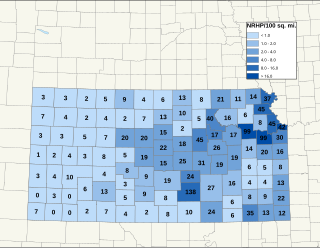
There are over 1,400 buildings, sites, districts, and objects in Kansas listed on the National Register of Historic Places in Kansas. NRHP listings appear in 101 of the state's 105 counties.

National Register of Historic Places listings in New Mexico

This is a list of properties and districts in New Mexico that are on the National Register of Historic Places. There are more than 1,100 listings. Of these, 46 are National Historic Landmarks. There are listings in each of the state's 33 counties.

National Register of Historic Places listings in Rhode Island

This is a list of properties and districts listed on the National Register of Historic Places in Rhode Island. As of May 29, 2015, there are more than 750 listed sites in Rhode Island. All 5 of the counties in Rhode Island have listings on the National Register.