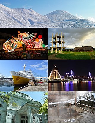
Aomori, officially Aomori City, is the capital city of Aomori Prefecture, in the Tōhoku region of Japan. As of 1 August 2023, the city had an estimated population of 264,945 in 136,781 households, and a population density of 321 people per square kilometer spread over the city's total area of 824.61 km2 (318.38 sq mi). Aomori is one of Japan's 62 core cities and the core of the Aomori metropolitan area.

Aomori Prefecture ([a̠o̞mo̞ɾʲikẽ̞ɴ]) is a prefecture of Japan in the Tōhoku region. The prefecture's capital, largest city, and namesake is the city of Aomori. Aomori is the northernmost prefecture on Japan's main island, Honshu, and is bordered by the Pacific Ocean to the east, Iwate Prefecture to the southeast, Akita Prefecture to the southwest, the Sea of Japan to the west, and Hokkaido across the Tsugaru Strait to the north. Aomori Prefecture is the 8th-largest prefecture, with an area of 9,645.64 km2 (3,724.20 sq mi), and the 31st-most populous prefecture, with more than 1.18 million people. Approximately 45 percent of Aomori Prefecture's residents live in its two core cities, Aomori and Hachinohe, which lie on coastal plains. The majority of the prefecture is covered in forested mountain ranges, with population centers occupying valleys and plains. Aomori is the third-most populous prefecture in the Tōhoku region, after Miyagi Prefecture and Fukushima Prefecture. Mount Iwaki, an active stratovolcano, is the prefecture's highest point, at almost 1,624.7 m (5,330 ft).
Hachinohe is a city located in Aomori Prefecture, Japan. As of 1 August 2023, the city had an estimated population of 216,416 in 110,195 households, and a population density of 708 persons per km², making it Aomori Prefecture's second largest city by population. The city has a total area of 305.56 square kilometres (117.98 sq mi).

Mutsu is a city located in Aomori Prefecture, Japan. As of 31 January 2023, the city had an estimated population of 53,804 in 28553, and a population density of 62 persons per km2. The total area of the city is 864.12 square kilometers (333.64 sq mi), making it the largest municipality in Aomori Prefecture in terms of area.

Nishimeya is a village located in Aomori Prefecture, Japan. As of 1 February 2023, the village had an estimated population of 1270 in 548 households, and a population density of 5.2 persons per km2. The total area of the village is 246.02 square kilometres (94.99 sq mi).
National Route 4 is a major national highway in eastern Honshū, Japan. Measuring 738.5 kilometers long (458.9 mi), it is the longest highway in the country. When oversea routes are included, it is the second longest highway in Japan, with National Route 58 then measuring 884.4 kilometers (549.5 mi) because of its maritime sections. The highway connects Tokyo and Aomori via Utsunomiya, Kōriyama, Sendai, and Morioka.

The Tōhoku Expressway is a south-north national expressway, and the longest expressway in Japan at 679.5 kilometers (422.2 mi). Its southern terminus is in Kawaguchi, Saitama in the Greater Tokyo Area, at the Tokyo Gaikan Expressway and Kawaguchi Route near Araijuku Station, and its northern terminus is at Aomori Interchange in Aomori, Aomori in the northern part of the Tōhoku region, where it meets the Aomori Expressway and Aomori Belt Highway near the Sannai-Maruyama Site.

Hirakawa is a city located in Aomori Prefecture, Japan. As of 31 January 2023, the city had an estimated population of 30,086 in 14,181 households, and a population density of 89 persons per km2. The total area of the city is 346.01 square kilometres (133.60 sq mi).
Nakadomari is a town located in Aomori Prefecture, Japan. As of 31 January 2023, the town had an estimated population of 9,981 in 4960 households, and a population density of 50 persons per km2. The total area of the town is 216.34 square kilometres (83.53 sq mi).

The Aomori Expressway is a two-lane national expressway spur route in Aomori, Aomori Prefecture, Japan. It is owned and operated by East Nippon Expressway Company and is signed E4A as a direct extension and spur route of the Tōhoku Expressway.
The Hachinohe Expressway is a 4-laned national expressway in the prefectures of Iwate and Aomori in the Tōhoku region of Japan. It is a spur of the Tōhoku Expressway, primarily serving the city of Hachinohe. Signed as E4A, it is owned and operated by East Nippon Expressway Company.
National Route 45 is a national highway of Japan connecting Aoba-ku, Sendai and Aomori, Aomori. Alongside Japan National Route 6, it is a main route along the Pacific coast of eastern Japan. It is paralleled closely by the incomplete Sanriku Expressway between Sendai and Hachinohe.

National Route 280 is a national highway of Japan that traverses the prefectures, Aomori and Hokkaido as well as the Tsugaru Strait that separates them. It currently is made up of two sections that travel 150.7 kilometres (93.6 mi) from Aomori, north across the Tsugaru Peninsula to Sotogahama where the first section ends at the site of a former ferry to across the Tsugaru Strait to the town, Fukushima. The other section begins at the corresponding former ferry terminal in Fukushima. The road then travels alongside the southern coast of Hokkaido concurrently with National Route 228 to Hakodate where the route meets its northern terminus.
National Route 454 is a national highway of Japan that traverses southern Aomori Prefecture and briefly crosses into the northeastern edge of Akita before returning in to Aomori. It connects Hachinohe in eastern Aomori to Ōwani in the western part of the prefecture.

The Iwaki River is a river that crosses western Aomori Prefecture, Japan. It is 102 kilometers (63 mi) in length and has a drainage area of 2,544 square kilometers (982 sq mi). Under the Rivers Act of 1964 the Iwaki is designated as a Class 1 River and is managed by the Japanese Ministry of Land, Infrastructure, Transport and Tourism. The Iwaki River is the longest river in Aomori Prefecture, and is the source of irrigation for the large-scale rice and apple production of the prefecture. The Iwaki River, in the Tōhoku region north of the Fukushima Daiichi Nuclear Power Plant, remains unpolluted by radioactive materials after the Fukushima Daiichi nuclear disaster. Testing for caesium-134 and caesium-137 is carried out and published on a bimonthly basis.

The Michinoku Toll Road is a two-lane toll road in Aomori Prefecture connecting the cities Aomori and Hachinohe via Shichinohe. It serves as an alternative to Japan National Route 4, bypassing the towns Hiranai and Noheji by cutting directly through the Hakkōda Mountains and other mountains of the northern Ōu Mountain Range. The road is managed by the Aomori Prefecture Road Corporation and is numbered E4A as an extension of the Tōhoku Expressway.

The Kamikita Expressway is a free two-lane expressway in Aomori Prefecture connecting the towns of Shichinohe and Rokunohe. Alongside other tolled roads, the expressway is part of a series of highways that will link the Hachinohe Expressway to the Aomori Expressway. The road is managed by the Ministry of Land, Infrastructure and Transport and is numbered E4A as an extension of the Tōhoku Expressway. It is routed concurrently with an alternate route of Japan National Route 45.

The Daini-Michinoku Toll Road is a two-lane toll road in Aomori Prefecture that connects the towns Rokunohe and Oirase. The Daini-Michinoku Toll Road was designated in 1987 as part of a single expressway running from the capital city of Aomori Prefecture, Aomori to the prefecture's second largest city, Hachinohe. The road is managed by the Aomori Prefecture Road Public Corporation and is numbered E4A as an extension of the Tōhoku Expressway.
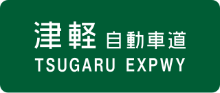
The Tsugaru Expressway is a two-lane national expressway in Aomori Prefecture, Japan. The expressway connects the prefecture's capital, Aomori, and the Tōhoku Expressway to the municipalities of Goshogawara, Tsugaru and, Ajigasawa. It is owned and operated by Ministry of Land, Infrastructure, Transport and Tourism and is signed as an auxiliary route of National Route 101 as well as E64 under their "2016 Proposal for Realization of Expressway Numbering."


