South Korea is located in East Asia, on the southern portion of the Korean Peninsula located out from the far east of the Asian landmass. The only country with a land border to South Korea is North Korea, lying to the north with 238 kilometres (148 mi) of the border running along the Korean Demilitarized Zone. South Korea is mostly surrounded by water and has 2,413 kilometres (1,499 mi) of coast line along three seas; to the west is the Yellow Sea, to the south is the East China Sea, and to the east is the Sea of Japan. Geographically, South Korea's landmass is approximately 100,032 square kilometres (38,623 sq mi). 290 square kilometres (110 sq mi) of South Korea are occupied by water. The approximate coordinates are 37° North, 128° East.

Morioka is the capital city of Iwate Prefecture located in the Tōhoku region of northern Japan. On 1 February 2021, the city had an estimated population of 290,700 in 132,719 households, and a population density of 328 per square kilometre (850/sq mi). The total area of the city is 886.47 square kilometres (342.27 sq mi).
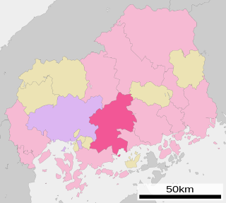
Higashihiroshima is a city located in Hiroshima Prefecture, Japan. As of July 31. 2016 the city has an estimated population of 185,418 and a population density of 291.85 persons per km2. The total area is 635.32 km2.

Asakura is a city located in south central Fukuoka Prefecture, Japan, on Kyūshū Island.

Shiwa is a town in Iwate Prefecture, Japan. As of 31 March 2020, the town had an estimated population of 33,090, in 12338 households, and a population density of 134 persons per km². The total area of the town is 238.98 square kilometres (92.27 sq mi).

Yahaba is a town in Iwate Prefecture, Japan. As of 1 April 2020, the town had an estimated population of 27,227, and a population density of 400 persons per km² in 10,131 households. The total area of the town is 67.32 square kilometres (25.99 sq mi).

Shiwa is a rural district located in Iwate Prefecture, Japan.
Shiwaguchi Station is a JR West Geibi Line station located in Ibara, Shiraki-chō, Asakita-ku, Hiroshima, Hiroshima Prefecture, Japan. The "Shiwa" in the name derives from the nearby Shiwa-chō, Higashihiroshima, despite there being no shuttle bus or other connection between the two locations. This station should not be confused with other stations of similar-sounding name on the Geibi Line: Shimowachi, Shiomachi, and Shiwachi. Even though Shiwaguchi Station is an express stop station, the Miyoshi Liner does not stop here due to lack of passengers using the station.

The Kitakami River is the fourth largest river in Japan and the largest in the Tōhoku region. It is 249 kilometres (155 mi) long and drains an area of 10,150 square kilometres (3,920 sq mi). It flows through mostly rural areas of Iwate and Miyagi Prefectures. The source of the river is the Mount Nanashiruge in northern Iwate, from which it flows to the south between the Kitakami Mountains and the Ōu Mountains. The river is unusual in that it has two mouths, one flowing south into Ishinomaki Bay and the other flowing east into the Pacific Ocean, both in Ishinomaki City.

National Route 396 is a national highway of Japan connecting Tōno, Iwate and Morioka, Iwate in Japan, with a total length of 58.7 km (36.47 mi).

Hizume Station is a railway station in the town of Shiwa, Iwate Prefecture, Japan, operated by East Japan Railway Company.

Shiwachūō Station is a railway station in the town of Shiwa, Iwate Prefecture, Japan, operated by East Japan Railway Company.

Furudate Station is a railway station in the town of Shiwa, Iwate Prefecture, Japan, operated by the East Japan Railway Company.
Yoshii Station is the railway station in Yoshii-chō Ōwatari, Sasebo, Nagasaki Prefecture. It is operated by Matsuura Railway and is on the Nishi-Kyūshū Line.
Omi Sato is a former Japanese football player.

The Sannōkai Dam is a dam on the Toyosawa River, a tributary of the Kitakami River system, located in the town of Shiwa, Iwate Prefecture in the Tōhoku region of the island of Honshū, Japan. It completed in 1952.

Iwate 1st district is a single-member constituency of the House of Representatives in the Diet of Japan. It is located in central Iwate and consists of the prefectural capital Morioka city and the two remaining towns in Shiwa district. Before 2017, it covered of the majority of the prefectural capital Morioka and Shiwa county. As of 2012, 278,860 eligible voters were registered in the district.

Shiwa Castle was an early Heian period jōsaku-style Japanese castle located in what is now part of the city of Morioka, Iwate Prefecture in the Tōhoku region of far northern Honshu, Japan. The site was proclaimed a National Historic Site of Japan in 1979.

Shiwa Ng'andu is a constituency of the National Assembly of Zambia. It covers the towns of Bulaya, Chibesakunda, Chibwa, Chitembo, Chitumbwe, Matumbo and Mutita in Muchinga Province, as well as the Shiwa Ngandu estate.