Related Research Articles

Panama, officially the Republic of Panama, is a transcontinental country in Central America, spanning the southern tip of North America into the northern part of South America. It is bordered by Costa Rica to the west, Colombia to the southeast, the Caribbean Sea to the north, and the Pacific Ocean to the south. Its capital and largest city is Panama City, whose metropolitan area is home to nearly half the country's over 4 million inhabitants.

The history of Panama includes the history of the Isthmus of Panama prior to European colonization.

Omar Efraín Torrijos Herrera was a dictator, as well as the Commander of the Panamanian National Guard and military leader of Panama from 1968 to his death in 1981. Torrijos was never officially the president of Panama, but instead held titles including "Maximum Leader of the Panamanian Revolution". Torrijos took power in a coup d'état and instituted a number of social reforms.

The Hay–Bunau-Varilla Treaty was a treaty signed on November 18, 1903, by the United States and Panama, which established the Panama Canal Zone and the subsequent construction of the Panama Canal. It was named after its two primary negotiators, Philippe-Jean Bunau-Varilla, the French diplomatic representative of Panama, and United States Secretary of State John Hay.

The Panama Canal Zone, also simply known as the Canal Zone, was an unincorporated and organized territory of the United States, located in the Isthmus of Panama, that existed from 1903 to 1979. It was located within the territory of Panama, consisting of the Panama Canal and an area generally extending five miles (8 km) on each side of the centerline, but excluding Panama City and Colón. Its capital was Balboa.
Balboa is a district of Panama City, located at the Pacific entrance to the Panama Canal.

The Torrijos–Carter Treaties are two treaties signed by the United States and Panama in Washington, D.C., on September 7, 1977, which superseded the Hay–Bunau-Varilla Treaty of 1903. The treaties guaranteed that Panama would gain control of the Panama Canal after 1999, ending the control of the canal that the U.S. had exercised since 1903. The treaties are named after the two signatories, U.S. president Jimmy Carter and the Commander of Panama's National Guard, General Omar Torrijos.

The idea of the Panama Canal dates back to 1517, when Vasco Núñez de Balboa first crossed the isthmus of Panama. The narrow land bridge between North and South America was a fine location to dig a water passage between the Atlantic and Pacific Oceans. The earliest European colonists recognized this, and several proposals for a canal were made.

Ancón is a corregimiento in Panamá District, Panamá Province, Panama with a population of 29,761 as of 2010. Its population as of 1990 was 11,518; its population as of 2000 was 11,169. It is sometimes considered a suburb or small town within Panama City, northeast of the limits of the town of Balboa. Ancon Hill is also the name of a large hill that overlooks Panama City and once served as a form of protection from pirates and sea invasion. The township was originally located around this hill, and was created to house employees of the Panama Canal during its construction. As part of the construction effort, the historic Gorgas Army Hospital was founded and built on the hillside. The first ship to officially transit the canal, SS Ancon, was named after the district. The community continued to serve as housing for employees of the Panama Canal Company until 1980, when parts of it began to be turned over to the Panamanian government under the 1977 Torrijos-Carter Treaties. Modern-day Ancón is a corregimiento of Panama City, serving mainly as a residential area. The Gorgas Army Hospital building is now the Panamanian Oncology Hospital, primarily used for cancer research. The area also houses Panama's Supreme Court, just a few feet away from the Gorgas Army Hospital building, and several Smithsonian Tropical Research Institute buildings for research into tropical biology. Ancón is also a parish (parroquia) of the District of Panama, located in the Panama Canal adjacent area.
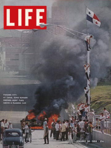
Martyrs' Day is a Panamanian day of national mourning which commemorates the January 9, 1964 anti-American riots over sovereignty of the Panama Canal Zone. The riot started after a Panamanian flag was torn and students were killed during a conflict with Canal Zone Police officers and Canal Zone residents. It is also known as the Flag Incident or Flag Protests.

Howard Air Force Base is a former United States Air Force base located in Panama. It discontinued military operations on 1 November 1999 as a result of the Torrijos-Carter Treaties, which specified that US military facilities in the former Panama Canal Zone be closed and the facilities be turned over to the Panamanian government.
The Remon–Eisenhower Treaty, was a 1955 treaty between the United States and Panama that updated and amended the original Hay–Bunau-Varilla Treaty of 1903 for the Panama Canal and Panama Canal Zone. Other aspects of the treaty covered local trader / worker rights, upgrades and military base usage.
Fort Clayton was a United States Army base in the former Panama Canal Zone, later part of the Republic of Panama.

The separation of Panama from Colombia was formalized on 3 November 1903, with the establishment of the Republic of Panama. From the Independence of Panama from Spain in 1821, Panama had simultaneously declared independence from Spain and joined itself to the confederation of Gran Colombia through the Independence Act of Panama. Panama was always tenuously connected to the rest of the country to the south, owing to its remoteness from the government in Bogotá and lack of a practical overland connection to the rest of Gran Colombia. In 1840–41, a short-lived independent republic was established under Tomás de Herrera. After rejoining Colombia following a 13-month independence, it remained a province which saw frequent rebellious flare-ups, notably the Panama crisis of 1885, which saw the intervention of the United States Navy, and a reaction by the Chilean Navy.

Albrook "Marcos A. Gelabert" International Airport is a public airport located 1.5 kilometres (1 mi) west of the center of Panama City, in the Panamá Province of Panama. It is on the site of the former Albrook Air Force Station. Previously, the airport was located in the area of Paitilla Punta Paitilla, operating approximately 70 years until January 1999, when the airport moved operations to Albrook. The name was changed to honor the Panamanian aviator Marcos A. Gelabert, whose contributions to Panamanian aviation included founding Panama's first airline and first school for training pilots.

Panama and the United States cooperate in promoting economic, political, security, and social development through international agencies.
Panama is a transcontinental country spanning the southern part of North America and the northern part of South America.
Panama is a transcontinental country spanning the southern part of North America and the northern part of South America.
Fort William D. Davis is a former U.S. Army fort near Gatun, Panama. It was transferred to Panama in 1995.

Naval Base Panama Canal Zone refers to a number of United States Navy bases used during World War II to both protect the Panama Canal and the key shipping lanes around the Panama Canal Zone. Bases were built and operated on the Atlantic Ocean side and the Pacific Ocean side. The main Naval Base at the Panama Canal was the Naval Station Coco Solo that had been in operation since 1918.
References
- ↑ William H. Ormsbee Jr (2009-01-30). "On this Site". WHOs scroll. Retrieved 2012-12-09.
- ↑ William H. Ormsbee Jr. "Panama Canal Treaty Transition -- Military: Summary of Military Property Transfers and Military Forces Drawdown". WHOs scroll. Retrieved 2012-12-09.
- ↑ "Home". canopytower.com.