WikiMili
List of forts in Mumbai
Last updated
October 10, 2025
Contents
List
Timeline
See also
References
Map all coordinates using
OpenStreetMap
Download coordinates as
KML
The following is a
list of
forts
in
Mumbai
.
List
Name
(other names)
Image
Built in
Built by
Locality
District
Type
Purpose
Razed
(by)
Current status
Current owner
Coordinates
Ref
Bombay Castle
Casa da Orta
Manor House
Governor House
INS
Angre
Unavailable
1554
Portuguese
Fort area
Mumbai City
Land battery
Administration
–
Preserved
Indian Navy
18°55′52″N
72°50′15″E
/
18.93111°N 72.83750°E
/
18.93111; 72.83750
[
1
]
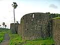
Castella de Aguada
Bandra Fort
1640
Portuguese
Bandra
Mumbai Suburban
Land battery
Watchtower, freshwater source
–
Under renovation
ASI
19°02′30″N
72°49′07″E
/
19.04177°N 72.81858°E
/
19.04177; 72.81858
Dongri Fort
Dungarey Fort
Unavailable
1596
Portuguese
Dongri
Mumbai City
Hill fort
Defensive
1769
(
British
)
Demolished
N/A
18°56′27″N
72°50′15″E
/
18.94090°N 72.83759°E
/
18.94090; 72.83759
[
2
]
Fort George
1770
British
Dongri
Mumbai City
Defensive
Defensive
1862
(
British
)
Remnants
Government of Maharashtra
18°56′27″N
72°50′15″E
/
18.94090°N 72.83759°E
/
18.94090; 72.83759
Riwa Fort
Kala Killa
Dharavi Fort
1737
British
Dharavi
Mumbai City
Land battery
Watchtower
–
Dilapidated
ASI
19°03′03″N
72°51′36″E
/
19.0509°N 72.86006°E
/
19.0509; 72.86006
Madh Fort
Versorva Fort
17th century
Portuguese
Madh Island
Mumbai Suburban
Land battery
Watchtower, prison
–
Stable
ASI
19°07′56″N
72°47′41″E
/
19.132283°N 72.794785°E
/
19.132283; 72.794785
[
3
]
Mahim Fort
13th century
Bhimdev
Mahim
Mumbai City
Land battery
Watchtower, defensive
–
Dilapidated
Government of Maharashtra
19°02′23″N
72°50′16″E
/
19.039848°N 72.837768°E
/
19.039848; 72.837768
[
4
]
Mazagon Fort
Unavailable
1680
British
Mazagon
Mumbai City
Land battery
Watchtower
1690
(
Yakut Khan
)
Demolished
MCGM
18°57′56″N
72°50′34″E
/
18.965633°N 72.842703°E
/
18.965633; 72.842703
Sion Fort
Sion Hillock Fort
1669
British
Sion
Mumbai City
Hill fort
Watchtower
–
Dilapidated
ASI
19°02′48″N
72°52′03″E
/
19.046583°N 72.867483°E
/
19.046583; 72.867483
Sewri Fort
Sewree Fort
1680
British
Sewri
Mumbai City
Hill fort
(also
Land battery
)
Watchtower
–
Under renovation
ASI
19°00′02″N
72°51′37″E
/
19.000635°N 72.860363°E
/
19.000635; 72.860363
Worli Fort
Worlee Fort
1675
British
Worli
Mumbai City
Land battery
Watchtower
–
Dilapidated
ASI
19°01′25″N
72°49′00″E
/
19.023732°N 72.816621°E
/
19.023732; 72.816621
Timeline
See also
Bassein Fort
Belapur Fort
List of forts in Maharashtra
References
↑
[
dead link
]
↑
Burnell, John (March 2007).
Bombay in the Days of Queen Anne - Being an Account of the Settlement Also
. Read Books.
ISBN
9781406755473
.
↑
"GAZETTEERS OF THE BOMBAY PRESIDENCY - THANA"
. Archived from
the original
on 12 February 2012
. Retrieved
15 September
2025
.
↑
"TOI
: New hope for Mahim fort
: Oct 26, 2007
|
Know Mumbai
|
People and Places of Special Interest
|
www.karmayog.org"
. Archived from
the original
on 4 March 2016
. Retrieved
28 September
2008
.
This page is based on this
Wikipedia article
Text is available under the
CC BY-SA 4.0
license; additional terms may apply.
Images, videos and audio are available under their respective licenses.