
Sitka is a unified city-borough in the southeast portion of the U.S. state of Alaska. It was formerly known as New Archangel while under Russian rule from 1799 to 1867. The city is situated on the west side of Baranof Island and the south half of Chichagof Island in the Alexander Archipelago of the Pacific Ocean. As of the 2020 census, Sitka had a population of 8,458, the fifth-most populated city in the state.

The Alexander Archipelago is a 300-mile (480 km) long archipelago in North America lying off the southeastern coast of Alaska. It contains about 1,100 islands, the tops of submerged coastal mountains that rise steeply from the Pacific Ocean. Deep channels and fjords separate the islands and cut them off from the mainland. The islands shelter the northern part of the Inside Passage as it winds its way among them.

Baranof Warm Springs is a small, primarily seasonally-occupied community located in the city and borough of Sitka, Alaska, on the eastern side of Baranof Island, from which it likely derives its name, in the Alexander Archipelago. It is occasionally referred to simply as Baranof. Baranof Warm Springs is located at 57°05′22″N134°49′59″W.

Baranof Lake is a glacially-fed, horseshoe-shaped lake on the eastern side of Baranof Island, in Alaska. Baranof Lake borders the community of Baranof Warm Springs and also has a Forest Service cabin on the northwestern end of the lake. Baranof River flows into the lake's western end and exits on the eastern end in rapids and a waterfall.
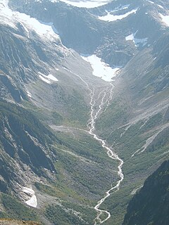
Baranof River is a glacially-fed river on the eastern side of Baranof Island, in the Alexander Archipelago, in the Alaska Panhandle. The source of the river is the unnamed icefields surrounding Peak 5390. Baranof River feeds into Baranof Lake, and the outlet of Baranof Lake that feeds into Warm Springs Bay is also commonly referred to as Baranof River as well.
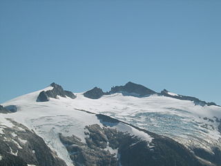
Peak 5390, also known as Veniaminof Peak and Lacey Peak, is the highest peak on Baranof Island and the Alexander Archipelago which are located in southeast Alaska. Peak 5390 is an informal name, named after the peak's height in feet, but is unnamed by USGS maps. Peak 5390 ranks as the highest island-based peak in the U.S. outside of the Aleutian Islands in Alaska and volcanos on Hawai‘i and Maui islands.

The Baranof Cross-Island Trail is an informal route across Baranof Island, Alaska from the community of Sitka to Baranof Warm Springs. The only section with a trail is from Medvejie to Camp Lake at 1,600'. The route is popular among resident Sitkans, but also attracts visiting backpackers. From start to finish, the trail spans approximately 16 miles (26 km) long, and 6,500' of elevation gain, but owing to the difficult terrain covered, the average crossing requires two to three days. Very-fit distance runners, however, can complete the trail in a day, the record being held by Sitka resident and ultra-endurance athlete Steve Reifenstuhl who has completed the trail in seven and a half hours.
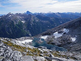
Camp Lake is a small snow-melt and rain-fed lake that feeds into the Blue Lake watershed on Baranof Island in the Alexander Archipelago in the Alaskan Panhandle. Camp Lake is a popular destination for the first night on the Baranof Cross-Island Trail due to its surrounding alpine meadow and the beautifully clear nature of the lake. Camp Lake sits between Bear Mountain and Mount Bassie and atop a small headwall on the Medvejie Lake valley, although the lake drains into the Blue Lake watershed. Departing from the Medvejie Hatchery, the trail to Camp Lake spans approximately 3.33 miles (5.4 km) but requires considerable effort due to the difficult terrain and, in certain sections, dense vegetation.

Medvejie Lake is a long, narrow, snow-fed lake on Baranof Island just south of Sitka, Alaska in the Alaskan Panhandle, which drains into Silver Bay, eight miles (13 km) southeast of Sitka, on west coast of Baranof Island, Alexander Archipelago.

Mount Bassie is a large mountain in the center of Baranof Island, Alaska, United States, within the City and Borough of Sitka.

Indian River is a roughly eight-mile long watershed that flows through the community of Sitka on Baranof Island in the Alexander Archipelago of Southeast Alaska.

USCGC Balsam (WLB-62) was a Cactus-class seagoing buoy tender (WLB) in the United States Coast Guard. She operated in the Pacific Ocean during World War II, then saw service along the United States West Coast, Hawaii, and Alaska. After her decommissioning in 1975, she was repurposed as a crab catcher-processor and is active in Alaskan fisheries as F/V Baranof.
Warm Springs Bay is a 2.4 mile-long bay located just outside the small community of Baranof Warm Springs on Baranof Island in the Alexander Archipelago, Alaska. Warm Springs Bay receives the outflow of Baranof Lake and Baranof River. Warm Springs Bay is located at 57°04′49″N134°48′12″W.
Mount Furuhelm is a 3,620 foot peak located on Baranof Island just east and adjacent to Peak 5390 in Alaska. It is located at 57°03′00″N134°55′47″W.
Baranov is a Russian surname.

Baranof Island is an island in the northern Alexander Archipelago in the Alaska Panhandle, in Alaska. The name Baranof was given in 1805 by Imperial Russian Navy captain U. F. Lisianski to honor Alexander Andreyevich Baranov. It was called Sheet’-ká X'áat'l by the native Tlingit people. It is the smallest of the ABC islands of Alaska.
The South Baranof Wilderness is a federally designated wilderness area within the Tongass National Forest, located on Baranof Island, Alaska. Covering 319,568 acres south of Sitka, the South Baranof protects glacier-carved fjords, hanging valleys, old-growth temperate rainforests and sheer granite mountains.
Nikolay Yakovlevich Rosenberg was an officer of the Imperial Russian Navy who was appointed as Chief Manager of the Russian-American Company, effectively Governor of Russian America, serving from 1850 to 1853. He was replaced before the end of the usual 5-year term because of his difficulties in managing relations with the native Tlingit peoples, who were important to the Russian fur trade and their survival. He may also have been called back to Russia to serve in the Crimean War, which included naval actions.

Baranof Warm Springs are a series of ten geothermal mineral springs located in the small community of Baranof Warm Springs in Sitka, Alaska. The springs are surrounded by the Tongass National Forest.